

<< Our Photo Pages >> Zvonigrad - Hillfort in Bosnia
Submitted by GeoHerzegovina on Friday, 19 April 2013 Page Views: 4354
Iron Age and Later PrehistorySite Name: ZvonigradCountry: Bosnia
NOTE: This site is 29.002 km away from the location you searched for.
Type: Hillfort
Nearest Town: Mostar Nearest Village: Gornji Polog
Latitude: 43.379539N Longitude: 17.690500E
Condition:
| 5 | Perfect |
| 4 | Almost Perfect |
| 3 | Reasonable but with some damage |
| 2 | Ruined but still recognisable as an ancient site |
| 1 | Pretty much destroyed, possibly visible as crop marks |
| 0 | No data. |
| -1 | Completely destroyed |
| 5 | Superb |
| 4 | Good |
| 3 | Ordinary |
| 2 | Not Good |
| 1 | Awful |
| 0 | No data. |
| 5 | Can be driven to, probably with disabled access |
| 4 | Short walk on a footpath |
| 3 | Requiring a bit more of a walk |
| 2 | A long walk |
| 1 | In the middle of nowhere, a nightmare to find |
| 0 | No data. |
| 5 | co-ordinates taken by GPS or official recorded co-ordinates |
| 4 | co-ordinates scaled from a detailed map |
| 3 | co-ordinates scaled from a bad map |
| 2 | co-ordinates of the nearest village |
| 1 | co-ordinates of the nearest town |
| 0 | no data |
Internal Links:
External Links:
")
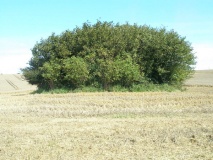
This hillfort is a real mystery and this location is not investigated hardly at all, but many treasure hunters have been here and there has been illegal digging. There are some parts of the walls with preserved megalithic large blocks of cretaceous limestone.
Most interesting is the geomorphology and geology of the site, which tells that ancient Illyrians had a very good knowledge of geology or stone characteristics. So, they built this hillfort or mayby town-Zvonigrad on a place with characteristic of limestone layers which are the best natural position wachtowers and fortress.
Location: 7.6 km WNW from Mostar city. 200-500 m W from Gornji Polog village, southern Bosnia and Herzegovina.
You may be viewing yesterday's version of this page. To see the most up to date information please register for a free account.
")
")
")
")
")
")
")
")
")
")
")
")
")
")
")
")
")
")
")
")
")
")
Do not use the above information on other web sites or publications without permission of the contributor.
Click here to see more info for this site
Nearby sites
Click here to view sites on an interactive map of the areaKey: Red: member's photo, Blue: 3rd party photo, Yellow: other image, Green: no photo - please go there and take one, Grey: site destroyed
Download sites to:
KML (Google Earth)
GPX (GPS waypoints)
CSV (Garmin/Navman)
CSV (Excel)
To unlock full downloads you need to sign up as a Contributory Member. Otherwise downloads are limited to 50 sites.
Turn off the page maps and other distractions
Nearby sites listing. In the following links * = Image available
23m SSW 201° Zvonigrad - fortification wall* Hillfort
2.9km SE 130° Polog.* Hillfort
15.3km S 179° Citluk-Greda-Illyrian observatory* Carving
31.2km S 175° Klepci tumuli 1* Round Barrow(s)
31.4km S 175° Klepci tumuli 2* Round Barrow(s)
33.7km S 189° Narona Town Wall* Hillfort
33.8km S 189° Narona Museum* Museum
36.1km SSE 148° Osanici Hillfort* Hillfort
64.6km SW 229° Nakovana Cave* Cave or Rock Shelter
75.5km NNE 31° Pyramid of Dragon* Natural Stone / Erratic / Other Natural Feature
76.4km NNE 32° Pyramid of Love* Natural Stone / Erratic / Other Natural Feature
76.8km NNE 31° Visoko Pyramid of Earth* Natural Stone / Erratic / Other Natural Feature
77.1km NNE 30° Visoko Pyramid of the Sun* Natural Stone / Erratic / Other Natural Feature
77.7km NNE 32° Visoko Pyramid of the Moon* Natural Stone / Erratic / Other Natural Feature
78.3km NE 47° Butmir* Ancient Village or Settlement
78.3km NNE 29° Ravne Tunnel Megaliths* Natural Stone / Erratic / Other Natural Feature
84.5km WSW 253° Tor Hillfort (Croatia)* Hillfort
84.9km WNW 293° Cetina Valley Ancient Village or Settlement
86.2km WSW 254° Hvar Island* Ancient Village or Settlement
90.0km W 262° Zmajeva Spilja* Cave or Rock Shelter
91.1km WSW 257° Pharos Town wall* Hillfort
91.1km WSW 256° Purkin Kuk Hillfort* Hillfort
91.2km WSW 256° Stari Grad Museum* Museum
93.0km W 267° Brac Island* Ancient Village or Settlement
95.2km SE 135° Crvena Stjena Cave or Rock Shelter
View more nearby sites and additional images


 We would like to know more about this location. Please feel free to add a brief description and any relevant information in your own language.
 Wir möchten mehr über diese Stätte erfahren. Bitte zögern Sie nicht, eine kurze Beschreibung und relevante Informationen in Deutsch hinzuzufügen.
 Nous aimerions en savoir encore un peu sur les lieux. S'il vous plaît n'hesitez pas à ajouter une courte description et tous les renseignements pertinents dans votre propre langue.
 Quisieramos informarnos un poco más de las lugares. No dude en añadir una breve descripción y otros datos relevantes en su propio idioma.