 with our Megalithic Portal iPhone app")


<< Text Pages >> Sperti Standing stone - Standing Stone (Menhir) in Italy in Puglia
Submitted by AlexHunger on Saturday, 25 March 2006 Page Views: 2249
Neolithic and Bronze AgeSite Name: Sperti Standing stoneCountry: Italy
NOTE: This site is 23.698 km away from the location you searched for.
Region: Puglia Type: Standing Stone (Menhir)
Nearest Town: Campi Salentina
Latitude: 40.395500N Longitude: 18.010190E
Condition:
| 5 | Perfect |
| 4 | Almost Perfect |
| 3 | Reasonable but with some damage |
| 2 | Ruined but still recognisable as an ancient site |
| 1 | Pretty much destroyed, possibly visible as crop marks |
| 0 | No data. |
| -1 | Completely destroyed |
| 5 | Superb |
| 4 | Good |
| 3 | Ordinary |
| 2 | Not Good |
| 1 | Awful |
| 0 | No data. |
| 5 | Can be driven to, probably with disabled access |
| 4 | Short walk on a footpath |
| 3 | Requiring a bit more of a walk |
| 2 | A long walk |
| 1 | In the middle of nowhere, a nightmare to find |
| 0 | No data. |
| 5 | co-ordinates taken by GPS or official recorded co-ordinates |
| 4 | co-ordinates scaled from a detailed map |
| 3 | co-ordinates scaled from a bad map |
| 2 | co-ordinates of the nearest village |
| 1 | co-ordinates of the nearest town |
| 0 | no data |
Internal Links:
External Links:
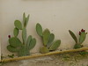
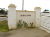
Menhir in Puglia
A 1.7 metre tall menhir in the grounds of Mamma Bella church and infants school.
You may be viewing yesterday's version of this page. To see the most up to date information please register for a free account.
Do not use the above information on other web sites or publications without permission of the contributor.
Nearby Images from Flickr


The above images may not be of the site on this page, but were taken nearby. They are loaded from Flickr so please click on them for image credits.
Click here to see more info for this site
Nearby sites
Click here to view sites on an interactive map of the areaKey: Red: member's photo, Blue: 3rd party photo, Yellow: other image, Green: no photo - please go there and take one, Grey: site destroyed
Download sites to:
KML (Google Earth)
GPX (GPS waypoints)
CSV (Garmin/Navman)
CSV (Excel)
To unlock full downloads you need to sign up as a Contributory Member. Otherwise downloads are limited to 50 sites.
Turn off the page maps and other distractions
Nearby sites listing. In the following links * = Image available
2.0km N 7° Candido Standing Stone Standing Stone (Menhir)
2.5km ESE 118° Menhir di Pietragrossa Standing Stone (Menhir)
14.2km SE 130° Aia della Corte Menhir* Standing Stone (Menhir)
16.2km SE 135° Calla a Tholos di Montalto Ancient Temple
17.2km S 174° Celimanna Standing Stone Standing Stone (Menhir)
18.7km ESE 118° Mura Megalitiche Hillfort
21.1km SE 129° Ussano Standing stone* Standing Stone (Menhir)
22.8km SE 133° Curti Vecchi Standing Stone* Standing Stone (Menhir)
23.1km SE 133° Lete Standing Stone* Standing Stone (Menhir)
24.2km ESE 115° Materdomini Menhir* Standing Stone (Menhir)
25.1km ESE 123° Luce Standing Stone* Standing Stone (Menhir)
27.8km N 349° Via Appia (Traiana)* Ancient Trackway
29.0km SE 139° Stazione Standing stone* Standing Stone (Menhir)
29.0km SE 124° Pietra di San Vito Standing Stone (Menhir)
29.6km ESE 121° Placa Dolmen* Burial Chamber or Dolmen
29.7km SE 136° Sant'Anna Menhir* Standing Stone (Menhir)
29.9km ESE 118° Gurgulante Dolmen* Burial Chamber or Dolmen
31.7km SSE 153° Pilamuzza Menhir Standing Stone (Menhir)
33.2km SE 131° Teofilo Menhir* Standing Stone (Menhir)
34.8km SE 128° Grassi Menhir* Standing Stone (Menhir)
34.8km SE 138° Scineo Menhir Standing Stone (Menhir)
34.9km SE 141° Corigliano Double Dolmen* Burial Chamber or Dolmen
35.1km SE 139° Massenia Piccinna Menhir Standing Stone (Menhir)
35.3km SE 126° Chianca di Santo Stefano Trilithon* Burial Chamber or Dolmen
35.4km SE 137° Minonna Standing stone* Standing Stone (Menhir)
View more nearby sites and additional images


 We would like to know more about this location. Please feel free to add a brief description and any relevant information in your own language.
 Wir möchten mehr über diese Stätte erfahren. Bitte zögern Sie nicht, eine kurze Beschreibung und relevante Informationen in Deutsch hinzuzufügen.
 Nous aimerions en savoir encore un peu sur les lieux. S'il vous plaît n'hesitez pas à ajouter une courte description et tous les renseignements pertinents dans votre propre langue.
 Quisieramos informarnos un poco más de las lugares. No dude en añadir una breve descripción y otros datos relevantes en su propio idioma.