

<< Our Photo Pages >> Kvernmo Sacrificial Site - Natural Stone / Erratic / Other Natural Feature in Norway in Troms
Submitted by kenntha88 on Sunday, 09 December 2007 Page Views: 3305
Natural PlacesSite Name: Kvernmo Sacrificial Site Alternative Name: NyheimCountry: Norway
NOTE: This site is 8.642 km away from the location you searched for.
Fylke: Troms Type: Natural Stone / Erratic / Other Natural Feature
Nearest Town: Narvik Nearest Village: Bjerkvik
Latitude: 68.646990N Longitude: 17.719617E
Condition:
| 5 | Perfect |
| 4 | Almost Perfect |
| 3 | Reasonable but with some damage |
| 2 | Ruined but still recognisable as an ancient site |
| 1 | Pretty much destroyed, possibly visible as crop marks |
| 0 | No data. |
| -1 | Completely destroyed |
| 5 | Superb |
| 4 | Good |
| 3 | Ordinary |
| 2 | Not Good |
| 1 | Awful |
| 0 | No data. |
| 5 | Can be driven to, probably with disabled access |
| 4 | Short walk on a footpath |
| 3 | Requiring a bit more of a walk |
| 2 | A long walk |
| 1 | In the middle of nowhere, a nightmare to find |
| 0 | No data. |
| 5 | co-ordinates taken by GPS or official recorded co-ordinates |
| 4 | co-ordinates scaled from a detailed map |
| 3 | co-ordinates scaled from a bad map |
| 2 | co-ordinates of the nearest village |
| 1 | co-ordinates of the nearest town |
| 0 | no data |
Internal Links:
External Links:
")
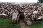
This space between the boulders is the site where the sacrificial goods were put. No signs of bones etc are visible today.
The site is inside a fir forest with a country road going just some few metres to the west of the site, and it is very easy to notice.
You may be viewing yesterday's version of this page. To see the most up to date information please register for a free account.
")
")
Do not use the above information on other web sites or publications without permission of the contributor.
Nearby Images from Flickr
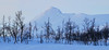

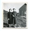
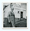
The above images may not be of the site on this page, but were taken nearby. They are loaded from Flickr so please click on them for image credits.
Click here to see more info for this site
Nearby sites
Click here to view sites on an interactive map of the areaKey: Red: member's photo, Blue: 3rd party photo, Yellow: other image, Green: no photo - please go there and take one, Grey: site destroyed
Download sites to:
KML (Google Earth)
GPX (GPS waypoints)
CSV (Garmin/Navman)
CSV (Excel)
To unlock full downloads you need to sign up as a Contributory Member. Otherwise downloads are limited to 50 sites.
Turn off the page maps and other distractions
Nearby sites listing. In the following links * = Image available
9.7km NNE 27° Spansdalen sacrificial site* Natural Stone / Erratic / Other Natural Feature
15.1km SW 216° Herjangen* Carving
15.8km ENE 73° Lapphaugen sacrificial site* Natural Stone / Erratic / Other Natural Feature
16.1km N 9° Lavangen* Barrow Cemetery
25.1km N 360° Andasteinen* Natural Stone / Erratic / Other Natural Feature
25.4km SSW 208° Narvik rock carving* Carving
29.1km NW 305° Vik on Rolla* Carving
34.7km S 187° Lillevann* Natural Stone / Erratic / Other Natural Feature
37.1km WNW 285° Sørrollnes* Cairn
38.0km W 264° Blåfjell sacrificial site* Natural Stone / Erratic / Other Natural Feature
43.6km SSW 203° Forselv* Carving
50.1km WNW 288° Harstad hill fort* Hillfort
50.5km NNW 328° Eidekjosen Settlement* Ancient Village or Settlement
51.4km WNW 294° Trondenes* Ancient Village or Settlement
51.6km WNW 303° Alvestad, Grytøya* Barrow Cemetery
53.0km WNW 299° Bessebostad, Grytøya* Barrow Cemetery
54.8km W 259° Hol-Tjeldsund Kirke* Round Barrow(s)
55.0km SW 231° Trollsteinen* Natural Stone / Erratic / Other Natural Feature
55.2km W 274° Storjorda sacrificial site* Natural Stone / Erratic / Other Natural Feature
57.9km W 261° Ballstad burial site* Barrow Cemetery
58.0km W 261° Ballstadneset* Standing Stone (Menhir)
59.0km W 261° Tjønneset* Barrow Cemetery
59.5km W 260° Sandsbukta boat houses* Ancient Village or Settlement
61.4km W 260° Ripelen cairns* Barrow Cemetery
61.5km NW 309° Bjarkøya barrow cemetary* Barrow Cemetery
View more nearby sites and additional images


 We would like to know more about this location. Please feel free to add a brief description and any relevant information in your own language.
 Wir möchten mehr über diese Stätte erfahren. Bitte zögern Sie nicht, eine kurze Beschreibung und relevante Informationen in Deutsch hinzuzufügen.
 Nous aimerions en savoir encore un peu sur les lieux. S'il vous plaît n'hesitez pas à ajouter une courte description et tous les renseignements pertinents dans votre propre langue.
 Quisieramos informarnos un poco más de las lugares. No dude en añadir una breve descripción y otros datos relevantes en su propio idioma.