 with our Megalithic Portal iPhone app")


<< Our Photo Pages >> Brac Island - Ancient Village or Settlement in Croatia
Submitted by thecaptain on Sunday, 03 October 2004 Page Views: 10293
Multi-periodSite Name: Brac IslandCountry: Croatia
NOTE: This site is 12.878 km away from the location you searched for.
Type: Ancient Village or Settlement
Latitude: 43.328000N Longitude: 16.543000E
Condition:
| 5 | Perfect |
| 4 | Almost Perfect |
| 3 | Reasonable but with some damage |
| 2 | Ruined but still recognisable as an ancient site |
| 1 | Pretty much destroyed, possibly visible as crop marks |
| 0 | No data. |
| -1 | Completely destroyed |
| 5 | Superb |
| 4 | Good |
| 3 | Ordinary |
| 2 | Not Good |
| 1 | Awful |
| 0 | No data. |
| 5 | Can be driven to, probably with disabled access |
| 4 | Short walk on a footpath |
| 3 | Requiring a bit more of a walk |
| 2 | A long walk |
| 1 | In the middle of nowhere, a nightmare to find |
| 0 | No data. |
| 5 | co-ordinates taken by GPS or official recorded co-ordinates |
| 4 | co-ordinates scaled from a detailed map |
| 3 | co-ordinates scaled from a bad map |
| 2 | co-ordinates of the nearest village |
| 1 | co-ordinates of the nearest town |
| 0 | no data |
Be the first person to rate this site - see the 'Contribute!' box in the right hand menu.
Internal Links:
External Links:
I have visited· I would like to visit
TheCaptain has visited here
")
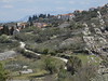
The large Adriatic island of Brac, which gets over 2700 hours of sunshine a year, is known worldwide for its white marble stone, which has been used for millennia in the creation of important buildings, two famous examples being the Diocletian Palace in Split, and the White House in Washington DC.
The island has been continuously populated since Neolithic times, with evidence of inhabitation found in caves such as Kopacina dating back to even the Mesolithic period.
There is more evidence of human settlement on the island during the Bronze Age, with a number of hilltop sites to be found across the island, and also many stone burial mounds. The first monuments on this rocky island are the piles of stone: stone shelters, tumuli, and forts.
More evidence exists of the Illyrian people living here during the Iron Age, of which a series of huge defended hillforts dating to this period have been found. The largest and the most significant of these were the hill forts built at various strategic points: Rat in the western part of the island near Lozisca, Kostilo above Bol, and the eastern most, Gracisce near Novo Selo. Remains of the Illyrian walls can also still be seen at Skrip, the oldest settlement on the island. The huge ruins in Skrip follow the Greek style but they were raised by the local Illyrian people, probably to resist the Greek occupation of the island.
It is thought that, unlike Hvar and other neighbouring islands, the Greeks never really colonised Brac, the Illyrians remaining dominant until the coming of the Romans. Once the Romans had complete control they consolidated their power in the newly-founded province of Dalmatia, whose capital, Solin (Salona), boasted a population of no less than 60,000. Roman domination lasted until the decline of the Western Roman Empire in 476. During this Roman period, hundreds of slaves toiled in the quarries of Brac island and left records of their life and worship on stones and sacrificial altars.
Christianisation then came to the Romans, and they were followed by the Byzantines, Slavs, Venetians, Turks, Austrians, French, English, Russians…… the rest is a long and complicated history.
You may be viewing yesterday's version of this page. To see the most up to date information please register for a free account.
Do not use the above information on other web sites or publications without permission of the contributor.
Nearby Images from Flickr
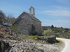

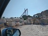
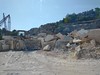

The above images may not be of the site on this page, but were taken nearby. They are loaded from Flickr so please click on them for image credits.
Click here to see more info for this site
Nearby sites
Click here to view sites on an interactive map of the areaKey: Red: member's photo, Blue: 3rd party photo, Yellow: other image, Green: no photo - please go there and take one, Grey: site destroyed
Download sites to:
KML (Google Earth)
GPX (GPS waypoints)
CSV (Garmin/Navman)
CSV (Excel)
To unlock full downloads you need to sign up as a Contributory Member. Otherwise downloads are limited to 50 sites.
Turn off the page maps and other distractions
Nearby sites listing. In the following links * = Image available
6.0km WNW 296° Gradina Rat Hillfort
8.1km SSE 152° Zmajeva Spilja* Cave or Rock Shelter
16.7km SSE 165° Pharos Town wall* Hillfort
16.8km SSE 165° Stari Grad Museum* Museum
17.7km SSW 211° Vira (Hvar)* Barrow Cemetery
18.2km SSE 165° Purkin Kuk Hillfort* Hillfort
18.9km SSW 206° Fortica* Hillfort
19.0km SSW 205° Hvar Castle Museum* Museum
19.1km SSW 206° Hvar Museum* Museum
20.5km SSE 151° Hvar Island* Ancient Village or Settlement
21.7km NNW 338° Diocletian's Palace* Ancient Palace
21.9km NNW 334° Split Archaeological Museum* Museum
23.6km SSE 148° Tor Hillfort (Croatia)* Hillfort
24.0km NNW 348° Solin Town Gate* Ancient Village or Settlement
24.0km NNW 348° Salona Town wall* Hillfort
25.8km N 356° Klis Hillfort* Hillfort
34.5km NW 311° Sutilija Hillfort* Hillfort
40.4km NNE 20° Cetina Valley Ancient Village or Settlement
57.3km SE 129° Nakovana Cave* Cave or Rock Shelter
65.2km NW 325° Pokrovnik Ancient Village or Settlement
80.4km NW 311° Arauzona Hillfort* Hillfort
87.0km NW 320° Varvaria* Hillfort
91.8km ESE 107° Narona Museum* Museum
91.9km ESE 107° Narona Town Wall* Hillfort
92.9km E 86° Zvonigrad - fortification wall* Hillfort
View more nearby sites and additional images


 We would like to know more about this location. Please feel free to add a brief description and any relevant information in your own language.
 Wir möchten mehr über diese Stätte erfahren. Bitte zögern Sie nicht, eine kurze Beschreibung und relevante Informationen in Deutsch hinzuzufügen.
 Nous aimerions en savoir encore un peu sur les lieux. S'il vous plaît n'hesitez pas à ajouter une courte description et tous les renseignements pertinents dans votre propre langue.
 Quisieramos informarnos un poco más de las lugares. No dude en añadir una breve descripción y otros datos relevantes en su propio idioma.