


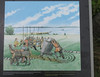
<< Our Photo Pages >> Karlevistenen - Standing Stone (Menhir) in Sweden in Öland
Submitted by Izozo on Tuesday, 07 November 2023 Page Views: 247
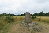
Iron Age and Later PrehistorySite Name: Karlevistenen Alternative Name: The Karlevi stoneCountry: Sweden
NOTE: This site is 6.505 km away from the location you searched for.
Landskap: Öland Type: Standing Stone (Menhir)
Nearest Town: Färjestaden Nearest Village: Karlevi
Latitude: 56.607542N Longitude: 16.439834E
Condition:
| 5 | Perfect |
| 4 | Almost Perfect |
| 3 | Reasonable but with some damage |
| 2 | Ruined but still recognisable as an ancient site |
| 1 | Pretty much destroyed, possibly visible as crop marks |
| 0 | No data. |
| -1 | Completely destroyed |
| 5 | Superb |
| 4 | Good |
| 3 | Ordinary |
| 2 | Not Good |
| 1 | Awful |
| 0 | No data. |
| 5 | Can be driven to, probably with disabled access |
| 4 | Short walk on a footpath |
| 3 | Requiring a bit more of a walk |
| 2 | A long walk |
| 1 | In the middle of nowhere, a nightmare to find |
| 0 | No data. |
| 5 | co-ordinates taken by GPS or official recorded co-ordinates |
| 4 | co-ordinates scaled from a detailed map |
| 3 | co-ordinates scaled from a bad map |
| 2 | co-ordinates of the nearest village |
| 1 | co-ordinates of the nearest town |
| 0 | no data |
Internal Links:
External Links:
")
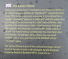
Drottkvät means ‘poem to a chieftain’ and the poem tells of a ‘king of the sea strong in battle’ named Sibbe, who has died. He is likened to Odin - the foremost AEsir god. The rune stone dates back to around AD1000, and was raised at a time of transition between the AEsir faith and Christianity. On the back of the stone you can read INONIN…RH, a corrupted form of IN NOMINE IHESU- In Jesus’ name.
You may be viewing yesterday's version of this page. To see the most up to date information please register for a free account.
")
Do not use the above information on other web sites or publications without permission of the contributor.
Nearby Images from Flickr
The above images may not be of the site on this page, but were taken nearby. They are loaded from Flickr so please click on them for image credits.
Click here to see more info for this site
Nearby sites
Click here to view sites on an interactive map of the areaKey: Red: member's photo, Blue: 3rd party photo, Yellow: other image, Green: no photo - please go there and take one, Grey: site destroyed
Download sites to:
KML (Google Earth)
GPX (GPS waypoints)
CSV (Garmin/Navman)
CSV (Excel)
To unlock full downloads you need to sign up as a Contributory Member. Otherwise downloads are limited to 50 sites.
Turn off the page maps and other distractions
Nearby sites listing. In the following links * = Image available
2.2km SE 126° Karlevi Stenkvarn* Stone Circle
3.4km ENE 71° Skogsby dolmen* Burial Chamber or Dolmen
3.5km ENE 69° Torslunda Stone* Standing Stone (Menhir)
3.5km ENE 69° Skogsby four-poster standing stones* Standing Stones
5.5km NNE 23° Färjestaden Domarring* Stone Circle
7.2km ENE 62° Degerrörsbacken* Cairn
8.2km S 178° Gynge Hög* Barrow Cemetery
8.8km S 180° Mysinge Hög* Barrow Cemetery
8.9km ESE 106° Dröstorps* Chambered Cairn
10.9km NE 46° Jordtorpsåsen* Standing Stones
12.0km ENE 57° Gråborg* Stone Fort or Dun
12.4km ESE 122° Frösslunda Gravfält* Standing Stones
13.6km ESE 117° Sandby borg Stone Fort or Dun
13.6km ENE 77° Dörby Stones* Standing Stones
14.1km SSE 158° Grösslunda Rör* Chambered Cairn
14.4km S 177° Stra Darby* Standing Stones
15.3km SSE 168° Tingstad Flisor* Standing Stones
15.4km SSE 148° Alby Mesolithic Village* Ancient Village or Settlement
17.7km ENE 60° Lopperstad* Standing Stones
19.7km NE 39° Ismantorps fornborg* Stone Fort or Dun
20.1km SSE 158° Hulterstad* Standing Stones
20.4km NNE 28° Höghäll* Standing Stones
20.8km NNE 32° Odens Flisor* Standing Stones
21.8km NE 52° Folkeslunda* Standing Stones
21.8km NNE 31° Karums Alvar* Stone Circle
View more nearby sites and additional images


 We would like to know more about this location. Please feel free to add a brief description and any relevant information in your own language.
 Wir möchten mehr über diese Stätte erfahren. Bitte zögern Sie nicht, eine kurze Beschreibung und relevante Informationen in Deutsch hinzuzufügen.
 Nous aimerions en savoir encore un peu sur les lieux. S'il vous plaît n'hesitez pas à ajouter une courte description et tous les renseignements pertinents dans votre propre langue.
 Quisieramos informarnos un poco más de las lugares. No dude en añadir una breve descripción y otros datos relevantes en su propio idioma.