 with our Megalithic Portal iPhone app")


<< Our Photo Pages >> Ledbergs kulle - Round Barrow(s) in Sweden in Östergötland
Submitted by CharcoalBurner89 on Sunday, 17 September 2023 Page Views: 104
Early Medieval (Dark Age)Site Name: Ledbergs kulle Alternative Name: LedbergshögenCountry: Sweden Landskap: Östergötland Type: Round Barrow(s)
Nearest Town: Linköping Nearest Village: Ledberg
Latitude: 58.440660N Longitude: 15.449340E
Condition:
| 5 | Perfect |
| 4 | Almost Perfect |
| 3 | Reasonable but with some damage |
| 2 | Ruined but still recognisable as an ancient site |
| 1 | Pretty much destroyed, possibly visible as crop marks |
| 0 | No data. |
| -1 | Completely destroyed |
| 5 | Superb |
| 4 | Good |
| 3 | Ordinary |
| 2 | Not Good |
| 1 | Awful |
| 0 | No data. |
| 5 | Can be driven to, probably with disabled access |
| 4 | Short walk on a footpath |
| 3 | Requiring a bit more of a walk |
| 2 | A long walk |
| 1 | In the middle of nowhere, a nightmare to find |
| 0 | No data. |
| 5 | co-ordinates taken by GPS or official recorded co-ordinates |
| 4 | co-ordinates scaled from a detailed map |
| 3 | co-ordinates scaled from a bad map |
| 2 | co-ordinates of the nearest village |
| 1 | co-ordinates of the nearest town |
| 0 | no data |
Internal Links:
External Links:
")
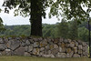
The Ledbergs kulle (also sometimes called Ledbergshögen) is the largest tumulus in Östergötland in Sweden. It dates back to the Viking Age (800-1050 AD) and is located between the rivers Lillån and Svartån, south of the Ledberg Church.
The unexcavated tumulus, about 6.5 meters high, has a diameter of about 45 meters. At the top there is a shallow pit about 2 meters in diameter. The depression probably has something to do with a flagpole that once stood on the tumulus.
In 1982, trenches were dug for cables. Charcoal collected from this site of the tumulus calibrated by 14C date of 780–990 AD. The area was examined with metal detectors in 2005 without any discoveries being made. In the past, a gold coin converted into a Merovingian ring, dated to 600 AD, was found.
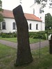
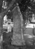
To the north of the tumulus lies the church of Ledberg. The proximity between the church and the tumulus indicates an early Christian context. This is reinforced by a runestone from the early 9th century, the so-called Ledbergstenen, which stands on the cemetery near the chruch.
(The text was taken from the German Wikipedia page and translated into English)
You may be viewing yesterday's version of this page. To see the most up to date information please register for a free account.
")
Do not use the above information on other web sites or publications without permission of the contributor.
Nearby Images from Flickr


The above images may not be of the site on this page, but were taken nearby. They are loaded from Flickr so please click on them for image credits.
Click here to see more info for this site
Nearby sites
Click here to view sites on an interactive map of the areaKey: Red: member's photo, Blue: 3rd party photo, Yellow: other image, Green: no photo - please go there and take one, Grey: site destroyed
Download sites to:
KML (Google Earth)
GPX (GPS waypoints)
CSV (Garmin/Navman)
CSV (Excel)
To unlock full downloads you need to sign up as a Contributory Member. Otherwise downloads are limited to 50 sites.
Turn off the page maps and other distractions
Nearby sites listing. In the following links * = Image available
229m NW 320° Ledbergsstenen* Carving
9.9km SE 141° Slakastenen (2)* Carving
9.9km SE 141° Slakastenen (1)* Carving
17.3km W 268° Lunds Backe* Stone Row / Alignment
19.8km W 264° Orsnäs* Stone Row / Alignment
21.7km WSW 257° Skänningestenen* Carving
22.1km WSW 246° Högbystenen (1)* Carving
22.1km WSW 246° Högbystenen (3)* Carving
22.1km WSW 246° Högbystenen (2)* Carving
22.2km WSW 246° Högbystenen (4)* Carving
24.2km SW 234° Mjölbystenen* Carving
25.5km WNW 294° Kanaljorden* Ancient Village or Settlement
32.4km W 272° Vadstenastenen* Carving
37.1km W 274° Nässja domarring* Stone Circle
42.5km WSW 248° Rökstenen* Carving
43.8km ENE 67° Himmelstalund* Carving
52.7km SSW 211° Balancing stone Tranås Natural Stone / Erratic / Other Natural Feature
72.9km NNW 346° Norrby stenar* Stone Circle
75.6km NNW 348° Lekebacken* Stone Circle
76.5km N 349° Hällabrottet* Passage Grave
80.7km NNW 338° Botåsen* Stone Circle
82.7km N 357° Tallbacken* Stone Circle
85.2km W 278° Sörgårdenstenen* Carving
86.3km N 1° Röhammar* Burial Chamber or Dolmen
86.4km W 281° Askeberga* Stone Circle
View more nearby sites and additional images


 We would like to know more about this location. Please feel free to add a brief description and any relevant information in your own language.
 Wir möchten mehr über diese Stätte erfahren. Bitte zögern Sie nicht, eine kurze Beschreibung und relevante Informationen in Deutsch hinzuzufügen.
 Nous aimerions en savoir encore un peu sur les lieux. S'il vous plaît n'hesitez pas à ajouter une courte description et tous les renseignements pertinents dans votre propre langue.
 Quisieramos informarnos un poco más de las lugares. No dude en añadir una breve descripción y otros datos relevantes en su propio idioma.