


<< Our Photo Pages >> KatsuragaOka Toride - Hillfort in Japan in Hokkaidō
Submitted by Aska on Wednesday, 16 May 2018 Page Views: 961
Medieval (High and Late)Site Name: KatsuragaOka Toride Alternative Name: Katsura-ga-Oka Toride 桂ヶ丘砦Country: Japan
NOTE: This site is 0.302 km away from the location you searched for.
Region: Hokkaidō Type: Hillfort
Nearest Town: Abashiri (Hokkaidō pref.) Nearest Village: Katsura-machi 桂町
Latitude: 44.017950N Longitude: 144.269990E
Condition:
| 5 | Perfect |
| 4 | Almost Perfect |
| 3 | Reasonable but with some damage |
| 2 | Ruined but still recognisable as an ancient site |
| 1 | Pretty much destroyed, possibly visible as crop marks |
| 0 | No data. |
| -1 | Completely destroyed |
| 5 | Superb |
| 4 | Good |
| 3 | Ordinary |
| 2 | Not Good |
| 1 | Awful |
| 0 | No data. |
| 5 | Can be driven to, probably with disabled access |
| 4 | Short walk on a footpath |
| 3 | Requiring a bit more of a walk |
| 2 | A long walk |
| 1 | In the middle of nowhere, a nightmare to find |
| 0 | No data. |
| 5 | co-ordinates taken by GPS or official recorded co-ordinates |
| 4 | co-ordinates scaled from a detailed map |
| 3 | co-ordinates scaled from a bad map |
| 2 | co-ordinates of the nearest village |
| 1 | co-ordinates of the nearest town |
| 0 | no data |
Internal Links:
External Links:
")
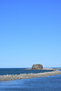
In the heart of Abashiri city, in front of Abashiri Municipal Folk Museum (網走市立郷土博物館) a double layered mound lie on a hill. This is a Chashi hillfort of Ainu people.
You may be viewing yesterday's version of this page. To see the most up to date information please register for a free account.
Do not use the above information on other web sites or publications without permission of the contributor.
Nearby Images from Flickr

The above images may not be of the site on this page, but were taken nearby. They are loaded from Flickr so please click on them for image credits.
Click here to see more info for this site
Nearby sites
Click here to view sites on an interactive map of the areaKey: Red: member's photo, Blue: 3rd party photo, Yellow: other image, Green: no photo - please go there and take one, Grey: site destroyed
Download sites to:
KML (Google Earth)
GPX (GPS waypoints)
CSV (Garmin/Navman)
CSV (Excel)
To unlock full downloads you need to sign up as a Contributory Member. Otherwise downloads are limited to 50 sites.
Turn off the page maps and other distractions
Nearby sites listing. In the following links * = Image available
804m N 349° Moyoro Kaizuka* Ancient Village or Settlement
4.1km SW 233° Abashiri prison* Modern Stone Circle etc
19.1km NW 306° Tokor Chashi* Hillfort
22.9km WNW 302° SakaeUra Iseki* Ancient Village or Settlement
26.6km WNW 297° Tokoro Iseki* Ancient Village or Settlement
34.3km ESE 110° OkushibetsuGawa* Stone Circle
39.7km ESE 109° Shuen* Henge
75.0km SW 215° Yuk'epira Chashi* Hillfort
76.5km E 88° Tobinitai* Ancient Village or Settlement
76.7km ESE 119° Ichani Karikariusu Chashi* Hillfort
76.7km ESE 119° Ichani Karikariusu* Ancient Village or Settlement
115.4km S 175° Mosirya Chashi* Hillfort
116.2km S 174° Charanke Chashi* Hillfort
118.3km SSE 156° Shika-otoshi-no Chashi* Hillfort
137.0km SSW 195° Otafunbe Chashi* Hillfort
140.3km ESE 119° Wonnemoto Chashi* Hillfort
169.1km W 260° Kamui-Kotan stone circle* Stone Circle
172.1km WSW 250° Nokanan henge* Henge
183.4km WSW 259° Otoe* Stone Circle
195.6km WSW 254° Hokkaidō Children's Land* Modern Stone Circle etc
238.4km SW 220° Mena Chashi* Hillfort
241.6km WSW 239° Kiusu* Henge
242.5km SW 220° Sibecar Chashi* Hillfort
242.9km SW 220° Hoinasir Chashi* Hillfort
243.2km WSW 247° Ebetsu Chashi* Hillfort
View more nearby sites and additional images


 We would like to know more about this location. Please feel free to add a brief description and any relevant information in your own language.
 Wir möchten mehr über diese Stätte erfahren. Bitte zögern Sie nicht, eine kurze Beschreibung und relevante Informationen in Deutsch hinzuzufügen.
 Nous aimerions en savoir encore un peu sur les lieux. S'il vous plaît n'hesitez pas à ajouter une courte description et tous les renseignements pertinents dans votre propre langue.
 Quisieramos informarnos un poco más de las lugares. No dude en añadir una breve descripción y otros datos relevantes en su propio idioma.