


<< Our Photo Pages >> Mohyla Chotouň - Artificial Mound in Czech Republic in Bohemia
Submitted by ladrin on Monday, 30 April 2018 Page Views: 1096
Multi-periodSite Name: Mohyla Chotouň Alternative Name: Homole sv. Prokopa, Chotouň TumulusCountry: Czech Republic
NOTE: This site is 5.4 km away from the location you searched for.
Region: Bohemia Type: Artificial Mound
Nearest Town: Kolín Nearest Village: Chotouň
Latitude: 50.065959N Longitude: 14.962579E
Condition:
| 5 | Perfect |
| 4 | Almost Perfect |
| 3 | Reasonable but with some damage |
| 2 | Ruined but still recognisable as an ancient site |
| 1 | Pretty much destroyed, possibly visible as crop marks |
| 0 | No data. |
| -1 | Completely destroyed |
| 5 | Superb |
| 4 | Good |
| 3 | Ordinary |
| 2 | Not Good |
| 1 | Awful |
| 0 | No data. |
| 5 | Can be driven to, probably with disabled access |
| 4 | Short walk on a footpath |
| 3 | Requiring a bit more of a walk |
| 2 | A long walk |
| 1 | In the middle of nowhere, a nightmare to find |
| 0 | No data. |
| 5 | co-ordinates taken by GPS or official recorded co-ordinates |
| 4 | co-ordinates scaled from a detailed map |
| 3 | co-ordinates scaled from a bad map |
| 2 | co-ordinates of the nearest village |
| 1 | co-ordinates of the nearest town |
| 0 | no data |
Internal Links:
External Links:
")
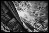
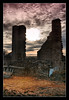
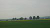
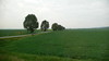
Probably the best preserved and definitely the most famous prehistoric tumulus in Czech republic. The mound localy known as a Homole (simply Hummock) is situated SE of the village Chotouň which is an ancient settlement where Saint Procopius of Sázava was born in 987 A.D. Also from another point of view is the person of St. Procopius important here.
Just about 300m south from the mound used to be the end/begining of so called Devil's Groove or Devil’s Furrow. This enigmatic prehistoric "highway" was directly associated with a legend of Procopius (for the details see the topic "Devil's Groove"). According the legend, the mound arose at the place where the devil threw the mud that he had scratched from the Procopius plough after digging the furrow. Anyway the question is obvious. Is proximity of these two ancient earthworks only coincidence?
Despite the lack of direct evidence, the mound is mostly being dated to the 7th century BC. It is very likely that it is the burial place of some important noble man of the Iron Age. A partial archeological survey from the 19th century did not bring any significant findings. Iron cross on the top of the tumulus is from 1808.
You may be viewing yesterday's version of this page. To see the most up to date information please register for a free account.
")
")
")
")
Do not use the above information on other web sites or publications without permission of the contributor.
Nearby Images from Flickr

The above images may not be of the site on this page, but were taken nearby. They are loaded from Flickr so please click on them for image credits.
Click here to see more info for this site
Nearby sites
Click here to view sites on an interactive map of the areaKey: Red: member's photo, Blue: 3rd party photo, Yellow: other image, Green: no photo - please go there and take one, Grey: site destroyed
Download sites to:
KML (Google Earth)
GPX (GPS waypoints)
CSV (Garmin/Navman)
CSV (Excel)
To unlock full downloads you need to sign up as a Contributory Member. Otherwise downloads are limited to 50 sites.
Turn off the page maps and other distractions
Nearby sites listing. In the following links * = Image available
7.3km SSE 167° Lechův Kámen* Rock Outcrop
7.6km SSE 165° Stará Kouřim* Hillfort
11.4km NNW 345° Hradištko Menhir* Standing Stone (Menhir)
13.8km NW 321° Přerovská Hůra* Hillfort
14.6km NNE 23° Prehistoric Barrow Nymburk* Chambered Cairn
17.0km W 276° Úvaly Stonehenge* Modern Stone Circle etc
17.9km ESE 105° Rondel Enclosures near Kolin Causewayed Enclosure
19.4km WSW 256° Prehistoric hillfort Březí* Hillfort
20.7km SSW 192° Devil's Groove* Misc. Earthwork
21.2km SE 130° Hill of Vysoka Modern Stone Circle etc
22.3km S 184° Stone Man* Standing Stone (Menhir)
22.5km SSW 194° Well of St.Procopius* Holy Well or Sacred Spring
22.9km ESE 113° Libenice Menhir* Modern Stone Circle etc
22.9km ESE 112° Libenice Shrine* Ancient Temple
23.5km SE 125° Wellspring of St. Vojtech* Standing Stone (Menhir)
23.5km SE 125° Spring of St. Vojtech* Holy Well or Sacred Spring
24.5km SE 126° Bylany Neolithic Settlement* Ancient Village or Settlement
24.9km ESE 118° Kutna Hora's stone circle* Modern Stone Circle etc
24.9km ESE 118° Kutná Hora Megaliths* Modern Stone Circle etc
25.1km ESE 114° Bába (The Hag)* Ancient Cross
25.2km SE 126° Bylany stone row* Stone Row / Alignment
25.2km ESE 115° Kaňk Menhir* Modern Stone Circle etc
29.0km WNW 287° Vinoř Rondel* Causewayed Enclosure
36.9km WSW 236° Dolmen na Kněží Hoře* Modern Stone Circle etc
37.0km WSW 237° Kněží Hora* Standing Stones
View more nearby sites and additional images


 We would like to know more about this location. Please feel free to add a brief description and any relevant information in your own language.
 Wir möchten mehr über diese Stätte erfahren. Bitte zögern Sie nicht, eine kurze Beschreibung und relevante Informationen in Deutsch hinzuzufügen.
 Nous aimerions en savoir encore un peu sur les lieux. S'il vous plaît n'hesitez pas à ajouter une courte description et tous les renseignements pertinents dans votre propre langue.
 Quisieramos informarnos un poco más de las lugares. No dude en añadir una breve descripción y otros datos relevantes en su propio idioma.