

, Aubrey Burl")
<< Our Photo Pages >> Dynegaard Gravrøse - Cairn in Denmark in Bornholm
Submitted by Boeddel on Saturday, 04 November 2023 Page Views: 467
Neolithic and Bronze AgeSite Name: Dynegaard GravrøseCountry: Denmark
NOTE: This site is 1.634 km away from the location you searched for.
County: Bornholm Type: Cairn
Nearest Town: Hasle Nearest Village: Olsker
Latitude: 55.230800N Longitude: 14.759456E
Condition:
| 5 | Perfect |
| 4 | Almost Perfect |
| 3 | Reasonable but with some damage |
| 2 | Ruined but still recognisable as an ancient site |
| 1 | Pretty much destroyed, possibly visible as crop marks |
| 0 | No data. |
| -1 | Completely destroyed |
| 5 | Superb |
| 4 | Good |
| 3 | Ordinary |
| 2 | Not Good |
| 1 | Awful |
| 0 | No data. |
| 5 | Can be driven to, probably with disabled access |
| 4 | Short walk on a footpath |
| 3 | Requiring a bit more of a walk |
| 2 | A long walk |
| 1 | In the middle of nowhere, a nightmare to find |
| 0 | No data. |
| 5 | co-ordinates taken by GPS or official recorded co-ordinates |
| 4 | co-ordinates scaled from a detailed map |
| 3 | co-ordinates scaled from a bad map |
| 2 | co-ordinates of the nearest village |
| 1 | co-ordinates of the nearest town |
| 0 | no data |
Internal Links:
External Links:
I have visited· I would like to visit
Boeddel visited on 30th Oct 2023 - their rating: Cond: 3 Amb: 4 Access: 4
")
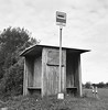
Flat overgrown cairn.
More information in Danish: Sted- og lokalitetsnr. 060106-77
“Fortidsmindedata Copyright Kulturarvstyrelsen”
You may be viewing yesterday's version of this page. To see the most up to date information please register for a free account.
")
")
Do not use the above information on other web sites or publications without permission of the contributor.
Nearby Images from Flickr


The above images may not be of the site on this page, but were taken nearby. They are loaded from Flickr so please click on them for image credits.
Click here to see more info for this site
Nearby sites
Click here to view sites on an interactive map of the areaKey: Red: member's photo, Blue: 3rd party photo, Yellow: other image, Green: no photo - please go there and take one, Grey: site destroyed
Download sites to:
KML (Google Earth)
GPX (GPS waypoints)
CSV (Garmin/Navman)
CSV (Excel)
To unlock full downloads you need to sign up as a Contributory Member. Otherwise downloads are limited to 50 sites.
Turn off the page maps and other distractions
Nearby sites listing. In the following links * = Image available
1.3km N 2° Nørre Krak Bautasten* Standing Stone (Menhir)
1.4km N 354° Nørre Krak Skåltegn* Rock Art
1.6km NNW 334° Kølleregård Skåltegn* Rock Art
1.8km SSW 199° Rutskerstenen* Sculptured Stone
2.0km WNW 299° Ringegård Skåltegn 2* Rock Art
2.0km WNW 300° Ringegård Skåltegn 1* Rock Art
2.7km NNE 20° Damvang Bautasten* Standing Stone (Menhir)
2.8km N 5° Lyngholtdyssen (Modern)* Modern Stone Circle etc
2.8km ENE 77° Olsker Skåltegn* Rock Art
2.9km NNW 344° Finnens Top Skåltegn* Rock Art
2.9km ENE 73° Olsker Lindesgårdsvej Skåltegn* Rock Art
3.0km NNE 29° Egelyhesten Skåltegn* Rock Art
3.3km NNE 12° Knægten-Munkegaard Rundhøj* Round Barrow(s)
3.3km NNE 15° Blåholtsgård Skåltegn 2* Rock Art
3.4km NNE 15° Blåholtsgård Skåltegn 1* Rock Art
3.4km ENE 70° Olsker Røvej Rundhøj* Round Barrow(s)
3.4km WSW 243° Wippehøj Rundhøj* Round Barrow(s)
3.4km NE 35° Sjælegård Skåltegn* Rock Art
3.4km NNE 11° Knægten Bautasten* Standing Stone (Menhir)
3.4km NE 35° Sjælegård Helleristninger Syd* Rock Art
3.4km NNE 15° Blåholt Bautasten* Standing Stone (Menhir)
3.4km N 10° Knægten Skåltegn* Rock Art
3.5km NE 34° Sjælegård Helleristninger Nord* Rock Art
3.5km N 11° Klingbjerg Gravrøse* Cairn
3.6km ESE 102° Muradamsvej Helleristninger (Modern)* Modern Stone Circle etc
View more nearby sites and additional images


 We would like to know more about this location. Please feel free to add a brief description and any relevant information in your own language.
 Wir möchten mehr über diese Stätte erfahren. Bitte zögern Sie nicht, eine kurze Beschreibung und relevante Informationen in Deutsch hinzuzufügen.
 Nous aimerions en savoir encore un peu sur les lieux. S'il vous plaît n'hesitez pas à ajouter une courte description et tous les renseignements pertinents dans votre propre langue.
 Quisieramos informarnos un poco más de las lugares. No dude en añadir una breve descripción y otros datos relevantes en su propio idioma.