

<< Our Photo Pages >> Onsbæk - Rock Art in Denmark in Bornholm
Submitted by Klingon on Monday, 10 November 2008 Page Views: 1993
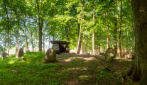
Rock ArtSite Name: OnsbækCountry: Denmark County: Bornholm Type: Rock Art
Latitude: 55.076439N Longitude: 14.741507E
Condition:
| 5 | Perfect |
| 4 | Almost Perfect |
| 3 | Reasonable but with some damage |
| 2 | Ruined but still recognisable as an ancient site |
| 1 | Pretty much destroyed, possibly visible as crop marks |
| 0 | No data. |
| -1 | Completely destroyed |
| 5 | Superb |
| 4 | Good |
| 3 | Ordinary |
| 2 | Not Good |
| 1 | Awful |
| 0 | No data. |
| 5 | Can be driven to, probably with disabled access |
| 4 | Short walk on a footpath |
| 3 | Requiring a bit more of a walk |
| 2 | A long walk |
| 1 | In the middle of nowhere, a nightmare to find |
| 0 | No data. |
| 5 | co-ordinates taken by GPS or official recorded co-ordinates |
| 4 | co-ordinates scaled from a detailed map |
| 3 | co-ordinates scaled from a bad map |
| 2 | co-ordinates of the nearest village |
| 1 | co-ordinates of the nearest town |
| 0 | no data |
Be the first person to rate this site - see the 'Contribute!' box in the right hand menu.
Internal Links:
External Links:
I have visited· I would like to visit
Boeddel visited on 20th May 2015 - their rating: Amb: 4 Access: 4
")
You may be viewing yesterday's version of this page. To see the most up to date information please register for a free account.
")
Do not use the above information on other web sites or publications without permission of the contributor.
Nearby Images from Flickr
The above images may not be of the site on this page, but were taken nearby. They are loaded from Flickr so please click on them for image credits.
Click here to see more info for this site
Nearby sites
Click here to view sites on an interactive map of the areaKey: Red: member's photo, Blue: 3rd party photo, Yellow: other image, Green: no photo - please go there and take one, Grey: site destroyed
Download sites to:
KML (Google Earth)
GPX (GPS waypoints)
CSV (Garmin/Navman)
CSV (Excel)
To unlock full downloads you need to sign up as a Contributory Member. Otherwise downloads are limited to 50 sites.
Turn off the page maps and other distractions
Nearby sites listing. In the following links * = Image available
308m SE 144° Ørnestenen* Standing Stone (Menhir)
482m ENE 69° Skåltegn Rønne Plantage* Rock Art
1.5km ESE 106° Rolfshøj Bautasten* Standing Stone (Menhir)
1.6km ESE 101° Roels Dal Bautasten* Standing Stones
1.6km ENE 68° Blemmelyng-Kællinghøj Bautasten 3* Standing Stone (Menhir)
1.6km ENE 68° Blemmelyng-Kællinghøj Bautasten 1* Standing Stone (Menhir)
1.7km ENE 68° Kællingehøj Bautasten* Standing Stone (Menhir)
1.7km ENE 67° Blemmelyng Marksystem* Misc. Earthwork
1.8km ESE 105° Køllergaard Bautasten* Standing Stones
1.9km ENE 75° Blemmelyng-Kællinghøj Bautasten 2* Standing Stone (Menhir)
1.9km NNE 16° Knudsker Bautasten 2* Standing Stones
1.9km NNE 16° Knudsker Bautasten 1* Standing Stones
2.0km ESE 116° Bavnehøj (Bornholm)* Rock Art
2.1km E 96° Hyldebrandsgård Jættestue* Passage Grave
2.4km E 98° Ellegaard Rundhøj* Round Barrow(s)
2.6km E 100° Kjøllergård Rundhøj* Round Barrow(s)
2.8km E 87° Slaus stene* Modern Stone Circle etc
3.5km N 11° Knudsker Runesten* Carving
3.6km NW 323° Modern Dolmen Rønne* Modern Stone Circle etc
3.6km SE 128° Arnager Jættestue* Passage Grave
3.7km NW 322° Bønnestene Rønne* Standing Stone (Menhir)
3.8km NW 320° Bornholms Museum* Rock Art
3.8km NW 320° Brunsgårdstenen* Sculptured Stone
4.0km NW 312° Storegade Runesten* Carving
4.0km SE 125° Nylarsker Skåltegn* Rock Art
View more nearby sites and additional images


 We would like to know more about this location. Please feel free to add a brief description and any relevant information in your own language.
 Wir möchten mehr über diese Stätte erfahren. Bitte zögern Sie nicht, eine kurze Beschreibung und relevante Informationen in Deutsch hinzuzufügen.
 Nous aimerions en savoir encore un peu sur les lieux. S'il vous plaît n'hesitez pas à ajouter une courte description et tous les renseignements pertinents dans votre propre langue.
 Quisieramos informarnos un poco más de las lugares. No dude en añadir una breve descripción y otros datos relevantes en su propio idioma.