


<< Text Pages >> Reitweiner Wallberge - Hillfort in Germany in Brandenburg, Berlin
Submitted by kaihofmann on Friday, 31 May 2013 Page Views: 1390
Iron Age and Later PrehistorySite Name: Reitweiner WallbergeCountry: Germany
NOTE: This site is 12.388 km away from the location you searched for.
Land: Brandenburg, Berlin Type: Hillfort
Nearest Town: Lebus Nearest Village: Reitwein
Latitude: 52.490833N Longitude: 14.578056E
Condition:
| 5 | Perfect |
| 4 | Almost Perfect |
| 3 | Reasonable but with some damage |
| 2 | Ruined but still recognisable as an ancient site |
| 1 | Pretty much destroyed, possibly visible as crop marks |
| 0 | No data. |
| -1 | Completely destroyed |
| 5 | Superb |
| 4 | Good |
| 3 | Ordinary |
| 2 | Not Good |
| 1 | Awful |
| 0 | No data. |
| 5 | Can be driven to, probably with disabled access |
| 4 | Short walk on a footpath |
| 3 | Requiring a bit more of a walk |
| 2 | A long walk |
| 1 | In the middle of nowhere, a nightmare to find |
| 0 | No data. |
| 5 | co-ordinates taken by GPS or official recorded co-ordinates |
| 4 | co-ordinates scaled from a detailed map |
| 3 | co-ordinates scaled from a bad map |
| 2 | co-ordinates of the nearest village |
| 1 | co-ordinates of the nearest town |
| 0 | no data |
Be the first person to rate this site - see the 'Contribute!' box in the right hand menu.
Internal Links:
External Links:
Hillfort in Brandenburg, Berlin
Germanic (Semnon tribe, Iron Age) to Slavonic hillfort near the river Oder.
You may be viewing yesterday's version of this page. To see the most up to date information please register for a free account.
Do not use the above information on other web sites or publications without permission of the contributor.
Nearby Images from Flickr
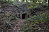
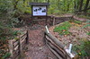
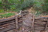
The above images may not be of the site on this page, but were taken nearby. They are loaded from Flickr so please click on them for image credits.
Click here to see more info for this site
Nearby sites
Click here to view sites on an interactive map of the areaKey: Red: member's photo, Blue: 3rd party photo, Yellow: other image, Green: no photo - please go there and take one, Grey: site destroyed
Download sites to:
KML (Google Earth)
GPX (GPS waypoints)
CSV (Garmin/Navman)
CSV (Excel)
To unlock full downloads you need to sign up as a Contributory Member. Otherwise downloads are limited to 50 sites.
Turn off the page maps and other distractions
Nearby sites listing. In the following links * = Image available
4.1km SSW 200° Klessin Neolithische Siedlung Ancient Village or Settlement
7.5km SSW 200° Lebus Burgberg Hillfort
12.5km W 280° Naepfchenstein Friedersdorf* Rock Art
17.6km SSW 212° Naefpchenstein Eduardspring Rock Art
19.4km S 182° Tzschetzschnower Burgwall Hillfort
19.5km SSW 198° Kanzelstein* Natural Stone / Erratic / Other Natural Feature
19.8km SSW 198° Schalenstein (Nuhnen)* Rock Art
20.2km WNW 301° Heimatmuseum Platkow Museum
21.6km WNW 302° Kreisgrabenanlage Platkow Henge
22.5km S 181° Lossow Burgwall* Hillfort
24.4km W 260° Teufelsstein Heinersdorf * Rock Art
24.4km WNW 302° Kreisgrabenanlage Quappendorf Henge
25.5km WSW 249° Arensdorf Wallanlage Ancient Village or Settlement
28.9km WSW 256° Tempelberg Steinkistengrab* Chambered Tomb
29.4km SSW 202° Heimatmuseum Müllrose* Museum
29.5km W 273° Muencheberg Kreuz Early Christian Sculptured Stone
31.7km WNW 285° Muenchehofe dune find spot* Natural Stone / Erratic / Other Natural Feature
32.5km SSW 201° Mixdorf Grabhuegelfeld Barrow Cemetery
33.0km NW 307° Wriezen Burgwall Ancient Village or Settlement
34.3km W 279° Waldsieversdorf Burgwall Hillfort
34.6km WNW 287° Teufelsstein Buckow Natural Stone / Erratic / Other Natural Feature
36.6km N 10° Grodzisko Smoliniec* Hillfort
39.0km WNW 285° Schaelchenstein Bollersdorf* Rock Art
40.3km SSW 211° Oegeln Steinkreuz Early Christian Sculptured Stone
40.8km SW 220° Klein-Rietz Steinkiste Cist
View more nearby sites and additional images


 We would like to know more about this location. Please feel free to add a brief description and any relevant information in your own language.
 Wir möchten mehr über diese Stätte erfahren. Bitte zögern Sie nicht, eine kurze Beschreibung und relevante Informationen in Deutsch hinzuzufügen.
 Nous aimerions en savoir encore un peu sur les lieux. S'il vous plaît n'hesitez pas à ajouter une courte description et tous les renseignements pertinents dans votre propre langue.
 Quisieramos informarnos un poco más de las lugares. No dude en añadir una breve descripción y otros datos relevantes en su propio idioma.