

<< Our Photo Pages >> Obrovy Hroby (Giants graves) - Misc. Earthwork in Czech Republic in Bohemia
Submitted by ladrin on Wednesday, 30 September 2015 Page Views: 1353
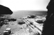
Neolithic and Bronze AgeSite Name: Obrovy Hroby (Giants graves) Alternative Name: HradištěCountry: Czech Republic
NOTE: This site is 1.964 km away from the location you searched for.
Region: Bohemia Type: Misc. Earthwork
Nearest Town: Milevsko Nearest Village: Kučeř
Latitude: 49.451539N Longitude: 14.248484E
Condition:
| 5 | Perfect |
| 4 | Almost Perfect |
| 3 | Reasonable but with some damage |
| 2 | Ruined but still recognisable as an ancient site |
| 1 | Pretty much destroyed, possibly visible as crop marks |
| 0 | No data. |
| -1 | Completely destroyed |
| 5 | Superb |
| 4 | Good |
| 3 | Ordinary |
| 2 | Not Good |
| 1 | Awful |
| 0 | No data. |
| 5 | Can be driven to, probably with disabled access |
| 4 | Short walk on a footpath |
| 3 | Requiring a bit more of a walk |
| 2 | A long walk |
| 1 | In the middle of nowhere, a nightmare to find |
| 0 | No data. |
| 5 | co-ordinates taken by GPS or official recorded co-ordinates |
| 4 | co-ordinates scaled from a detailed map |
| 3 | co-ordinates scaled from a bad map |
| 2 | co-ordinates of the nearest village |
| 1 | co-ordinates of the nearest town |
| 0 | no data |
Internal Links:
External Links:
 (PID:138364)")
The site is supposed to be a viereckschanze - a rectangular Celtic sacred place. Each of the four sides is about 60 m in length and up to 3,5 m in height.
You may be viewing yesterday's version of this page. To see the most up to date information please register for a free account.
 (PID:138363)")
 (PID:138362)")
Do not use the above information on other web sites or publications without permission of the contributor.
Click here to see more info for this site
Nearby sites
Click here to view sites on an interactive map of the areaKey: Red: member's photo, Blue: 3rd party photo, Yellow: other image, Green: no photo - please go there and take one, Grey: site destroyed
Download sites to:
KML (Google Earth)
GPX (GPS waypoints)
CSV (Garmin/Navman)
CSV (Excel)
To unlock full downloads you need to sign up as a Contributory Member. Otherwise downloads are limited to 50 sites.
Turn off the page maps and other distractions
Nearby sites listing. In the following links * = Image available
3.6km NNE 17° Koška Menhir* Standing Stone (Menhir)
4.3km WSW 251° Hlízová Tower Zvíkov* Carving
6.5km N 7° Vesec Stone Gate* Natural Stone / Erratic / Other Natural Feature
7.3km N 11° Angel Stone Vesec* Natural Stone / Erratic / Other Natural Feature
7.5km N 357° Vesec Sphinx* Natural Stone / Erratic / Other Natural Feature
8.6km E 89° Milevsko stone cross I.* Ancient Cross
10.0km E 86° Menhir Milevsko* Standing Stone (Menhir)
10.1km NNE 29° Horychová 2* Standing Stone (Menhir)
10.3km NNE 31° Horychová 1* Standing Stone (Menhir)
12.4km SSE 159° Olešná Propitiatory cross* Ancient Cross
13.2km NNE 32° Vrškámen* Natural Stone / Erratic / Other Natural Feature
13.6km SE 136° Bernartice stone cross 1* Ancient Cross
14.7km NE 46° Králov Menhir* Standing Stone (Menhir)
14.7km SE 135° Bernartice stone cross 2* Ancient Cross
14.8km S 170° Chrestovice* Standing Stone (Menhir)
15.3km NNE 33° Husova Kazatelna* Natural Stone / Erratic / Other Natural Feature
15.4km ESE 102° Sepekov barrow cemetery* Barrow Cemetery
15.8km NE 54° Kozlov 1 Menhir* Standing Stone (Menhir)
16.1km NE 53° Kozlov 2 Menhir* Standing Stone (Menhir)
16.2km SSE 149° Barrow Cemetery Nemějice Hůrka* Barrow Cemetery
16.3km ENE 70° Křesílko* Standing Stone (Menhir)
16.4km SSE 153° Nemějice modern stone circle* Modern Stone Circle etc
16.6km SSE 153° Tábor sanctum and barrow cemetery* Barrow Cemetery
16.7km NE 41° Ikarta Stone* Standing Stone (Menhir)
17.0km ENE 71° Nadějkov stone cross* Ancient Cross
View more nearby sites and additional images


 We would like to know more about this location. Please feel free to add a brief description and any relevant information in your own language.
 Wir möchten mehr über diese Stätte erfahren. Bitte zögern Sie nicht, eine kurze Beschreibung und relevante Informationen in Deutsch hinzuzufügen.
 Nous aimerions en savoir encore un peu sur les lieux. S'il vous plaît n'hesitez pas à ajouter une courte description et tous les renseignements pertinents dans votre propre langue.
 Quisieramos informarnos un poco más de las lugares. No dude en añadir una breve descripción y otros datos relevantes en su propio idioma.