


<< Our Photo Pages >> Ta’ Ċenċ Cart Ruts II - Ancient Trackway in Malta in Gozo
Submitted by KaiHofmann on Sunday, 11 February 2024 Page Views: 94
Multi-periodSite Name: Ta’ Ċenċ Cart Ruts IICountry: Malta Island: Gozo Type: Ancient Trackway
Nearest Town: Xewkija Nearest Village: Sannat
Latitude: 36.021016N Longitude: 14.253716E
Condition:
| 5 | Perfect |
| 4 | Almost Perfect |
| 3 | Reasonable but with some damage |
| 2 | Ruined but still recognisable as an ancient site |
| 1 | Pretty much destroyed, possibly visible as crop marks |
| 0 | No data. |
| -1 | Completely destroyed |
| 5 | Superb |
| 4 | Good |
| 3 | Ordinary |
| 2 | Not Good |
| 1 | Awful |
| 0 | No data. |
| 5 | Can be driven to, probably with disabled access |
| 4 | Short walk on a footpath |
| 3 | Requiring a bit more of a walk |
| 2 | A long walk |
| 1 | In the middle of nowhere, a nightmare to find |
| 0 | No data. |
| 5 | co-ordinates taken by GPS or official recorded co-ordinates |
| 4 | co-ordinates scaled from a detailed map |
| 3 | co-ordinates scaled from a bad map |
| 2 | co-ordinates of the nearest village |
| 1 | co-ordinates of the nearest town |
| 0 | no data |
Internal Links:
External Links:
")
two Cart ruts close to the Ta’ Ċenċ Dolmens.
You may be viewing yesterday's version of this page. To see the most up to date information please register for a free account.
")
")
Do not use the above information on other web sites or publications without permission of the contributor.
Nearby Images from Flickr
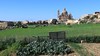
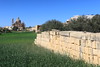
The above images may not be of the site on this page, but were taken nearby. They are loaded from Flickr so please click on them for image credits.
Click here to see more info for this site
Nearby sites
Click here to view sites on an interactive map of the areaKey: Red: member's photo, Blue: 3rd party photo, Yellow: other image, Green: no photo - please go there and take one, Grey: site destroyed
Download sites to:
KML (Google Earth)
GPX (GPS waypoints)
CSV (Garmin/Navman)
CSV (Excel)
To unlock full downloads you need to sign up as a Contributory Member. Otherwise downloads are limited to 50 sites.
Turn off the page maps and other distractions
Nearby sites listing. In the following links * = Image available
180m ENE 58° Id- Dura tax-Xaghra L-Kbira* Burial Chamber or Dolmen
202m ENE 66° Id-Dura tal-Mara* Burial Chamber or Dolmen
210m ENE 62° Ta' Cenc Gallery Grave* Chambered Tomb
285m ESE 107° L-Imramma Temple* Ancient Temple
624m SE 128° Ta' Cenc Cart Ruts* Ancient Trackway
695m E 98° Id- Dura tal-Imramma* Burial Chamber or Dolmen
715m E 98° Ta’ Ċenċ Dolmen III* Burial Chamber or Dolmen
748m NNE 14° Ta' Blankas Dolmen A* Burial Chamber or Dolmen
781m NNE 15° Ta' Blankas Dolmen B* Burial Chamber or Dolmen
840m NNE 17° Ta' Blankas Cart Ruts* Ancient Trackway
863m N 10° Ta' Blankas Stone Row* Stone Row / Alignment
1.6km ENE 66° Ta' Lambert Stones* Stone Row / Alignment
1.7km ENE 70° Ta' Lambert Cart Ruts* Ancient Trackway
1.8km NNW 329° Tac-Cawla Settlement* Ancient Village or Settlement
1.9km NW 318° Ta' Marziena* Ancient Temple
2.7km WNW 299° Wied tax-Xlendi Tomb* Chambered Tomb
2.9km NE 37° In-Nuffara Settlement* Ancient Village or Settlement
2.9km ENE 71° L-Imrejzbiet* Stone Circle
2.9km N 11° Santa Verna* Ancient Temple
3.0km ENE 69° Borg il-Gharib* Ancient Temple
3.0km NNE 20° Xaghra Circle* Stone Circle
3.0km NW 320° Kercem Rock Cut Tombs* Rock Cut Tomb
3.0km NNW 335° Gozo Museum of Archaeology* Museum
3.1km NNE 23° Ggantija Standing Stones* Standing Stones
3.1km NNE 20° L'Ghar ta' Gejzu* Cave or Rock Shelter
View more nearby sites and additional images


 We would like to know more about this location. Please feel free to add a brief description and any relevant information in your own language.
 Wir möchten mehr über diese Stätte erfahren. Bitte zögern Sie nicht, eine kurze Beschreibung und relevante Informationen in Deutsch hinzuzufügen.
 Nous aimerions en savoir encore un peu sur les lieux. S'il vous plaît n'hesitez pas à ajouter une courte description et tous les renseignements pertinents dans votre propre langue.
 Quisieramos informarnos un poco más de las lugares. No dude en añadir una breve descripción y otros datos relevantes en su propio idioma.