 with our Megalithic Portal iPhone app")

<< Our Photo Pages >> Havängsdösen - Burial Chamber or Dolmen in Sweden in Skåne
Submitted by greywether on Thursday, 21 July 2005 Page Views: 9034
Neolithic and Bronze AgeSite Name: Havängsdösen Alternative Name: RAÄ Ravlunda 40:1Country: Sweden
NOTE: This site is 10.802 km away from the location you searched for.
Landskap: Skåne Type: Burial Chamber or Dolmen
Nearest Town: Brosarp Nearest Village: Vitemölla
Latitude: 55.726100N Longitude: 14.194550E
Condition:
| 5 | Perfect |
| 4 | Almost Perfect |
| 3 | Reasonable but with some damage |
| 2 | Ruined but still recognisable as an ancient site |
| 1 | Pretty much destroyed, possibly visible as crop marks |
| 0 | No data. |
| -1 | Completely destroyed |
| 5 | Superb |
| 4 | Good |
| 3 | Ordinary |
| 2 | Not Good |
| 1 | Awful |
| 0 | No data. |
| 5 | Can be driven to, probably with disabled access |
| 4 | Short walk on a footpath |
| 3 | Requiring a bit more of a walk |
| 2 | A long walk |
| 1 | In the middle of nowhere, a nightmare to find |
| 0 | No data. |
| 5 | co-ordinates taken by GPS or official recorded co-ordinates |
| 4 | co-ordinates scaled from a detailed map |
| 3 | co-ordinates scaled from a bad map |
| 2 | co-ordinates of the nearest village |
| 1 | co-ordinates of the nearest town |
| 0 | no data |
Internal Links:
External Links:
I have visited· I would like to visit
43559959 visited on 5th Jul 2008 - their rating: Cond: 3 Amb: 4 Access: 4
DrewParsons have visited here
")
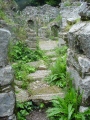
Long dolmen wonderfully sited near the sea.
You may be viewing yesterday's version of this page. To see the most up to date information please register for a free account.
")
")
")
")
")
")
")
")
")
")
")
")
")
")
")
")
")
")
")
")
Do not use the above information on other web sites or publications without permission of the contributor.
Click here to see more info for this site
Nearby sites
Click here to view sites on an interactive map of the areaKey: Red: member's photo, Blue: 3rd party photo, Yellow: other image, Green: no photo - please go there and take one, Grey: site destroyed
Download sites to:
KML (Google Earth)
GPX (GPS waypoints)
CSV (Garmin/Navman)
CSV (Excel)
To unlock full downloads you need to sign up as a Contributory Member. Otherwise downloads are limited to 50 sites.
Turn off the page maps and other distractions
Nearby sites listing. In the following links * = Image available
1.9km S 184° Heimdall Stenar* Stone Circle
5.4km SSE 153° Kungagraven* Chambered Cairn
5.8km SSE 148° Ängakåsen stone circle* Stone Circle
5.8km SSE 149° Ängakåsen stone ship* Stone Circle
8.6km SE 145° Stenshuvud Hillfort
17.9km SSE 163° Gladsax 2 Passage Grave* Passage Grave
20.2km SSE 164° Järrestad* Rock Art
20.9km S 188° Stenhed* Stone Circle
21.1km S 175° Totaskulle* Burial Chamber or Dolmen
22.6km SSE 159° Simris Runstenar* Carving
22.7km SSE 159° Simris Kyrka Stone* Standing Stone (Menhir)
23.1km SSE 154° Simris Rock Carving Panel* Rock Art
28.0km WSW 254° Tyge sten Natural Stone / Erratic / Other Natural Feature
29.3km N 11° Rinkaby Stone Circle* Stone Circle
31.2km SW 226° Baldringestenen* Carving
31.4km SSW 196° Glemminge Dyssestenen Burial Chamber or Dolmen
32.3km S 176° Lunnabjär-Gravfält* Cairn
32.4km SSW 209° Stora Köpingestenen* Carving
32.8km SSW 208° Trollasten Dolmen* Burial Chamber or Dolmen
33.3km S 187° Hagestad Stendösa Passage Grave
33.4km SSW 200° Glemminge Klövasten* Natural Stone / Erratic / Other Natural Feature
34.1km SSW 199° Ingelstorp Skrepphög Passage Grave
34.9km S 185° Carlshögen Passage Grave
35.3km S 183° Ramshög* Passage Grave
35.9km S 187° Albertshög Passage Grave
View more nearby sites and additional images


 We would like to know more about this location. Please feel free to add a brief description and any relevant information in your own language.
 Wir möchten mehr über diese Stätte erfahren. Bitte zögern Sie nicht, eine kurze Beschreibung und relevante Informationen in Deutsch hinzuzufügen.
 Nous aimerions en savoir encore un peu sur les lieux. S'il vous plaît n'hesitez pas à ajouter une courte description et tous les renseignements pertinents dans votre propre langue.
 Quisieramos informarnos un poco más de las lugares. No dude en añadir una breve descripción y otros datos relevantes en su propio idioma.