


<< Our Photo Pages >> Hayano Yokoana - Rock Cut Tomb in Japan in Honshū
Submitted by Aska on Sunday, 08 May 2011 Page Views: 3589
Rock ArtSite Name: Hayano Yokoana Alternative Name: 早野横穴Country: Japan
NOTE: This site is 5.108 km away from the location you searched for.
Region: Honshū Type: Rock Cut Tomb
Nearest Town: Kawasaki (Kanagawa pref.) Nearest Village: Hayano 早野
Latitude: 35.573060N Longitude: 139.519170E
Condition:
| 5 | Perfect |
| 4 | Almost Perfect |
| 3 | Reasonable but with some damage |
| 2 | Ruined but still recognisable as an ancient site |
| 1 | Pretty much destroyed, possibly visible as crop marks |
| 0 | No data. |
| -1 | Completely destroyed |
| 5 | Superb |
| 4 | Good |
| 3 | Ordinary |
| 2 | Not Good |
| 1 | Awful |
| 0 | No data. |
| 5 | Can be driven to, probably with disabled access |
| 4 | Short walk on a footpath |
| 3 | Requiring a bit more of a walk |
| 2 | A long walk |
| 1 | In the middle of nowhere, a nightmare to find |
| 0 | No data. |
| 5 | co-ordinates taken by GPS or official recorded co-ordinates |
| 4 | co-ordinates scaled from a detailed map |
| 3 | co-ordinates scaled from a bad map |
| 2 | co-ordinates of the nearest village |
| 1 | co-ordinates of the nearest town |
| 0 | no data |
Internal Links:
External Links:
")
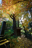
A burial cave on a slope of a hill behind the parking area of the office of the Hayano Seichi Kōen (早野聖地公園) cemetery park. The innermost wall of the cave has a panoramic carving describing the life of the buried one, a stock farmer (?).
The entrance of the cave is hidden with tall weed and hard to find, and the inner chamber is occupied by the swarm of giant house centipedes.
A replica of the carving is exhibited in Kawasaki Shimin Myūjiamu (川崎市民ミュージアム = Kawasaki City Museum, 35.58865N,139.64775E).
You may be viewing yesterday's version of this page. To see the most up to date information please register for a free account.
Do not use the above information on other web sites or publications without permission of the contributor.
Nearby Images from Flickr

The above images may not be of the site on this page, but were taken nearby. They are loaded from Flickr so please click on them for image credits.
Click here to see more info for this site
Nearby sites
Click here to view sites on an interactive map of the areaKey: Red: member's photo, Blue: 3rd party photo, Yellow: other image, Green: no photo - please go there and take one, Grey: site destroyed
Download sites to:
KML (Google Earth)
GPX (GPS waypoints)
CSV (Garmin/Navman)
CSV (Excel)
To unlock full downloads you need to sign up as a Contributory Member. Otherwise downloads are limited to 50 sites.
Turn off the page maps and other distractions
Nearby sites listing. In the following links * = Image available
2.5km SE 132° Ichigao Yokoana* Rock Cut Tomb
7.5km E 81° Maginu Kofun* Passage Grave
10.6km NW 314° Inarizuka Kofun* Passage Grave
11.4km N 9° Tenmondai-Kōnai Kofun* Passage Grave
11.7km ENE 72° Noge Ōtsuka Kofun* Long Barrow
12.7km NNW 334° Musashi-Fuchū Kumano-Jinja Kofun* Passage Grave
13.6km E 83° Sengen Jinja Kofun* NOT SET
14.3km NE 54° Gōtoku-ji temple* Modern Stone Circle etc
14.4km WNW 282° Tabata* Stone Circle
19.2km E 83° Ōmori Kaizuka* Ancient Village or Settlement
22.9km S 174° Shichikokuyama Yokoana* Rock Cut Tomb
23.8km S 180° Senbagayatsu Yokoana* Rock Cut Tomb
24.6km SSW 206° Koshinoyama Yokoana* Rock Cut Tomb
25.0km ENE 62° Hemisphere* Modern Stone Circle etc
26.6km S 174° Meigetsu-in temple* Modern Stone Circle etc
27.0km S 173° Kenchō-ji temple* Modern Stone Circle etc
27.2km NE 54° Yayoi* Ancient Mine, Quarry or other Industry
27.8km S 170° Zuisen-ji temple* Modern Stone Circle etc
27.8km ENE 65° Kiyosumi Teien garden* Modern Stone Circle etc
28.0km NW 312° Sedo-oka Kofungun* Chambered Cairn
28.2km S 170° Jōmyō-ji temple* Modern Stone Circle etc
28.6km SW 228° Sannomiya-Shimoyato* Stone Circle
30.2km S 174° Kōmyō-ji temple (in Kamakura)* Modern Stone Circle etc
34.2km SW 216° Manda Miyanoiri Yokoana* Rock Cut Tomb
35.6km SW 216° Shōgakubo Yokoana* Rock Cut Tomb
View more nearby sites and additional images


 We would like to know more about this location. Please feel free to add a brief description and any relevant information in your own language.
 Wir möchten mehr über diese Stätte erfahren. Bitte zögern Sie nicht, eine kurze Beschreibung und relevante Informationen in Deutsch hinzuzufügen.
 Nous aimerions en savoir encore un peu sur les lieux. S'il vous plaît n'hesitez pas à ajouter une courte description et tous les renseignements pertinents dans votre propre langue.
 Quisieramos informarnos un poco más de las lugares. No dude en añadir una breve descripción y otros datos relevantes en su propio idioma.