


<< Our Photo Pages >> Yaze - Ancient Village or Settlement in Japan in Honshū
Submitted by Aska on Tuesday, 07 August 2012 Page Views: 2743
Neolithic and Bronze AgeSite Name: Yaze Alternative Name: 矢瀬遺跡Country: Japan
NOTE: This site is 23.233 km away from the location you searched for.
Region: Honshū Type: Ancient Village or Settlement
Nearest Town: Minakami-machi (Gunma pref.) Nearest Village: Tsukiyono 月夜野
Latitude: 36.696880N Longitude: 138.982190E
Condition:
| 5 | Perfect |
| 4 | Almost Perfect |
| 3 | Reasonable but with some damage |
| 2 | Ruined but still recognisable as an ancient site |
| 1 | Pretty much destroyed, possibly visible as crop marks |
| 0 | No data. |
| -1 | Completely destroyed |
| 5 | Superb |
| 4 | Good |
| 3 | Ordinary |
| 2 | Not Good |
| 1 | Awful |
| 0 | No data. |
| 5 | Can be driven to, probably with disabled access |
| 4 | Short walk on a footpath |
| 3 | Requiring a bit more of a walk |
| 2 | A long walk |
| 1 | In the middle of nowhere, a nightmare to find |
| 0 | No data. |
| 5 | co-ordinates taken by GPS or official recorded co-ordinates |
| 4 | co-ordinates scaled from a detailed map |
| 3 | co-ordinates scaled from a bad map |
| 2 | co-ordinates of the nearest village |
| 1 | co-ordinates of the nearest town |
| 0 | no data |
Internal Links:
External Links:
")
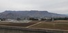
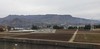
An ancient (3300BC-2100BC) village of Jōmon era built on the bank of upper stream of Tone-gawa (利根川) river, including houses, stone circles (grave yard), timber circles and sacred fountain with standing stones.
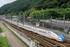
Just 1 km from Jōmō Kōgen (上毛高原) station of Jōetsu bullet express train. There are 2 more sites on the way : Fukazawa (深沢遺跡 36.69485N,138.98080E)) and Nashi-no-ki Daira (梨の木平遺跡 36.69485N,138.98088E)
a detailed personal site
You may be viewing yesterday's version of this page. To see the most up to date information please register for a free account.
")
")
")
Do not use the above information on other web sites or publications without permission of the contributor.
Nearby Images from Flickr


The above images may not be of the site on this page, but were taken nearby. They are loaded from Flickr so please click on them for image credits.
Click here to see more info for this site
Nearby sites
Click here to view sites on an interactive map of the areaKey: Red: member's photo, Blue: 3rd party photo, Yellow: other image, Green: no photo - please go there and take one, Grey: site destroyed
Download sites to:
KML (Google Earth)
GPX (GPS waypoints)
CSV (Garmin/Navman)
CSV (Excel)
To unlock full downloads you need to sign up as a Contributory Member. Otherwise downloads are limited to 50 sites.
Turn off the page maps and other distractions
Nearby sites listing. In the following links * = Image available
11.1km S 185° Gunma Astronomical Observatory* Modern Stone Circle etc
19.7km S 178° Kanai Higashiura* Ancient Village or Settlement
20.2km S 180° Kanai Kofun* Passage Grave
29.4km S 172° Mitsuya Kofun* Passage Grave
34.2km S 169° Ōyama Kofun* Chambered Cairn
35.1km S 179° Hodota Hachimanzuka Kofun* Long Barrow
37.8km S 185° Inarimori* Chambered Cairn
38.3km SE 142° Takei Haiji* Not Known (by us)
39.1km SSE 151° Ōmuro Kofungun (in Gunma)* Passage Grave
40.4km SE 132° Hōtoku-ji temple* Modern Stone Circle etc
45.0km SSW 212° Sakamoto-Kitaura* Stone Circle
46.9km S 175° Yama-no-Ue Kofun* Passage Grave
48.2km S 174° Isezuka Kofun* Passage Grave
50.3km S 181° Ipponsugi Kofun* Passage Grave
51.9km SE 133° Itakura Jinja shrine* Standing Stone (Menhir)
53.2km NNW 338° Kurinokida* Stone Circle
53.7km WNW 289° Oni-no Kama Kofun* Chambered Cairn
53.9km WNW 291° Waguri Kofun* Passage Grave
54.3km WNW 289° Asahi Gōro Kofun* Chambered Cairn
54.6km WNW 289° Nezuka Iseki* Chambered Cairn
55.1km E 83° Taiyū-in shrine* Modern Stone Circle etc
55.1km W 273° Kingaizan Kofun* Chambered Cairn
56.3km SW 222° Mozawa Minami-Ishidō* Stone Circle
57.2km W 278° Hayashiguro Kofun* Passage Grave
57.6km W 270° Ganshōin Kofungun* Chambered Cairn
View more nearby sites and additional images


 We would like to know more about this location. Please feel free to add a brief description and any relevant information in your own language.
 Wir möchten mehr über diese Stätte erfahren. Bitte zögern Sie nicht, eine kurze Beschreibung und relevante Informationen in Deutsch hinzuzufügen.
 Nous aimerions en savoir encore un peu sur les lieux. S'il vous plaît n'hesitez pas à ajouter une courte description et tous les renseignements pertinents dans votre propre langue.
 Quisieramos informarnos un poco más de las lugares. No dude en añadir una breve descripción y otros datos relevantes en su propio idioma.