 with our Megalithic Portal iPhone app")
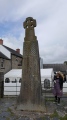

<< Our Photo Pages >> Kitazawa - Standing Stone (Menhir) in Japan in Honshū
Submitted by Aska on Sunday, 16 March 2008 Page Views: 4502
Neolithic and Bronze AgeSite Name: Kitazawa Alternative Name: 北沢石棒Country: Japan
NOTE: This site is 25.075 km away from the location you searched for.
Region: Honshū Type: Standing Stone (Menhir)
Nearest Town: Sakuho-machi (Nagano pref.) Nearest Village: Takano-machi 高野町
Latitude: 36.164656N Longitude: 138.476529E
Condition:
| 5 | Perfect |
| 4 | Almost Perfect |
| 3 | Reasonable but with some damage |
| 2 | Ruined but still recognisable as an ancient site |
| 1 | Pretty much destroyed, possibly visible as crop marks |
| 0 | No data. |
| -1 | Completely destroyed |
| 5 | Superb |
| 4 | Good |
| 3 | Ordinary |
| 2 | Not Good |
| 1 | Awful |
| 0 | No data. |
| 5 | Can be driven to, probably with disabled access |
| 4 | Short walk on a footpath |
| 3 | Requiring a bit more of a walk |
| 2 | A long walk |
| 1 | In the middle of nowhere, a nightmare to find |
| 0 | No data. |
| 5 | co-ordinates taken by GPS or official recorded co-ordinates |
| 4 | co-ordinates scaled from a detailed map |
| 3 | co-ordinates scaled from a bad map |
| 2 | co-ordinates of the nearest village |
| 1 | co-ordinates of the nearest town |
| 0 | no data |
Internal Links:
External Links:
")
The greatest "Ishi-bō (=stone stick)". Phallus-like "Ishi-bō" are usually found around the furnaces in residencial ruins, this one was found on the riverside of the Kitazawa-gawa river and re-erected in a rice field nearby.
You may be viewing yesterday's version of this page. To see the most up to date information please register for a free account.
Do not use the above information on other web sites or publications without permission of the contributor.
Nearby Images from Flickr
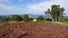


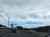
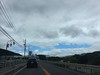
The above images may not be of the site on this page, but were taken nearby. They are loaded from Flickr so please click on them for image credits.
Click here to see more info for this site
Nearby sites
Click here to view sites on an interactive map of the areaKey: Red: member's photo, Blue: 3rd party photo, Yellow: other image, Green: no photo - please go there and take one, Grey: site destroyed
Download sites to:
KML (Google Earth)
GPX (GPS waypoints)
CSV (Garmin/Navman)
CSV (Excel)
To unlock full downloads you need to sign up as a Contributory Member. Otherwise downloads are limited to 50 sites.
Turn off the page maps and other distractions
Nearby sites listing. In the following links * = Image available
18.9km NNE 24° Mozawa Minami-Ishidō* Stone Circle
27.7km SW 232° Togariishi* Ancient Village or Settlement
30.1km NE 46° Sakamoto-Kitaura* Stone Circle
32.4km SW 216° Tsubodaira* Burial Chamber or Dolmen
36.1km SSW 193° Kinsei* Stone Circle
36.6km WSW 256° Manji-no Sekibutsu* Sculptured Stone
36.6km SSW 209° Mukōhara* Stone Circle
37.9km NW 314° Jingū-ji Kofun* Passage Grave
41.8km SSW 195° Mumei-no Daisekitō* Modern Stone Circle etc
43.3km W 280° Harizuka Kofun* Chambered Cairn
45.6km W 262° Shiojiri Honjin* Modern Stone Circle etc
45.8km ENE 79° Ipponsugi Kofun* Passage Grave
46.6km NW 322° Nakayama Kofun* Chambered Cairn
47.5km ENE 63° Inarimori* Chambered Cairn
47.7km NW 311° Azaka Shōgunzuka Kofun* Chambered Cairn
47.8km NW 311° Azaka Nakamura Kofun* Chambered Cairn
48.2km NNW 333° Kuwanei YoroiZuka Kofungun* Chambered Cairn
48.3km NNW 327° Sugiyama Kofungun* Chambered Cairn
48.3km NNW 333° Kuwanei SoraZuka Kofun* Chambered Cairn
48.4km NNW 333° Kuwanei Kubo Kofun* Chambered Cairn
48.4km NNW 333° Makiuchi Kofungun* Chambered Cairn
48.6km SSE 155° Somaguchi* Standing Stone (Menhir)
48.9km NW 310° Oisawa Kofungun* Chambered Cairn
49.0km SW 224° Onshō-ji temple* Modern Stone Circle etc
49.7km NNW 334° Sugama Ōtsuka Kofun* Chambered Cairn
View more nearby sites and additional images


 We would like to know more about this location. Please feel free to add a brief description and any relevant information in your own language.
 Wir möchten mehr über diese Stätte erfahren. Bitte zögern Sie nicht, eine kurze Beschreibung und relevante Informationen in Deutsch hinzuzufügen.
 Nous aimerions en savoir encore un peu sur les lieux. S'il vous plaît n'hesitez pas à ajouter une courte description et tous les renseignements pertinents dans votre propre langue.
 Quisieramos informarnos un poco más de las lugares. No dude en añadir una breve descripción y otros datos relevantes en su propio idioma.