


<< Our Photo Pages >> Devil's Marbles - Natural Stone / Erratic / Other Natural Feature in Australia
Submitted by Klingon on Friday, 15 July 2005 Page Views: 17432
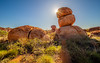
Natural PlacesSite Name: Devil's MarblesCountry: Australia Type: Natural Stone / Erratic / Other Natural Feature
Nearest Town: Kurundi Nearest Village: Singleton
Latitude: 20.568056S Longitude: 134.261389E
Condition:
| 5 | Perfect |
| 4 | Almost Perfect |
| 3 | Reasonable but with some damage |
| 2 | Ruined but still recognisable as an ancient site |
| 1 | Pretty much destroyed, possibly visible as crop marks |
| 0 | No data. |
| -1 | Completely destroyed |
| 5 | Superb |
| 4 | Good |
| 3 | Ordinary |
| 2 | Not Good |
| 1 | Awful |
| 0 | No data. |
| 5 | Can be driven to, probably with disabled access |
| 4 | Short walk on a footpath |
| 3 | Requiring a bit more of a walk |
| 2 | A long walk |
| 1 | In the middle of nowhere, a nightmare to find |
| 0 | No data. |
| 5 | co-ordinates taken by GPS or official recorded co-ordinates |
| 4 | co-ordinates scaled from a detailed map |
| 3 | co-ordinates scaled from a bad map |
| 2 | co-ordinates of the nearest village |
| 1 | co-ordinates of the nearest town |
| 0 | no data |
Be the first person to rate this site - see the 'Contribute!' box in the right hand menu.
Internal Links:
External Links:
I have visited· I would like to visit
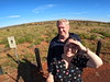
Arjessa has visited here
")
You may be viewing yesterday's version of this page. To see the most up to date information please register for a free account.
")
Do not use the above information on other web sites or publications without permission of the contributor.
coldrum has found this location on Google Street View:
Nearby Images from Flickr

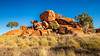
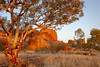
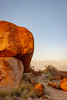
The above images may not be of the site on this page, but were taken nearby. They are loaded from Flickr so please click on them for image credits.
Click here to see more info for this site
Nearby sites
Click here to view sites on an interactive map of the areaKey: Red: member's photo, Blue: 3rd party photo, Yellow: other image, Green: no photo - please go there and take one, Grey: site destroyed
Download sites to:
KML (Google Earth)
GPX (GPS waypoints)
CSV (Garmin/Navman)
CSV (Excel)
To unlock full downloads you need to sign up as a Contributory Member. Otherwise downloads are limited to 50 sites.
Turn off the page maps and other distractions
Nearby sites listing. In the following links * = Image available
459.7km SSW 194° Henbury Meteorite Craters* Natural Stone / Erratic / Other Natural Feature
625.5km SSW 211° Ayers Rock* Rock Art
693.9km WNW 282° Wolf Creek Crater Natural Stone / Erratic / Other Natural Feature
859.7km NNW 347° Kakadu* Rock Art
906.4km N 351° Kakadu - Madjedbebe* Cave or Rock Shelter
917.8km N 351° Kakadu - Ubirr* Rock Art
935.1km N 357° Nawarla Gabarnmung rock art site Rock Art
994.1km NW 306° Drysdale River National Park Rock Art
1072.3km NW 310° Kalumburu Cave or Rock Shelter
1140.7km E 80° Kinara Volcano Natural Stone / Erratic / Other Natural Feature
1212.5km ENE 65° Spilt Rock Park Rock Art Rock Art
1245.3km SSE 161° Warratyi* Cave or Rock Shelter
1281.1km SSW 199° Koonalda Cave Cave or Rock Shelter
1290.5km SSE 161° Nala Stone Men* Modern Stone Circle etc
1548.6km NNW 330° Jerimalai Cave or Rock Shelter
1584.5km WSW 258° Hope Downs Cave or Rock Shelter
1622.5km SE 139° 25-3-0057 Stone Row / Alignment
1685.0km SE 135° 17-1-0006 Stone Row / Alignment
1696.2km W 264° Nunyerry Creek* Rock Art
1701.0km SSE 151° Mungo, Australia* Ancient Village or Settlement
1717.7km W 259° Pibara Petroglyphs* Rock Art
1786.9km SE 135° 27-2-0004 Stone Row / Alignment
1818.2km W 267° Burrup Peninsula* Rock Art
1862.6km N 359° Bitsyari Bay, West Papua* Rock Art
1900.6km SW 217° Esperance Stonehenge* Modern Stone Circle etc
View more nearby sites and additional images


 We would like to know more about this location. Please feel free to add a brief description and any relevant information in your own language.
 Wir möchten mehr über diese Stätte erfahren. Bitte zögern Sie nicht, eine kurze Beschreibung und relevante Informationen in Deutsch hinzuzufügen.
 Nous aimerions en savoir encore un peu sur les lieux. S'il vous plaît n'hesitez pas à ajouter une courte description et tous les renseignements pertinents dans votre propre langue.
 Quisieramos informarnos un poco más de las lugares. No dude en añadir una breve descripción y otros datos relevantes en su propio idioma.