 with our Megalithic Portal iPhone app")


<< Our Photo Pages >> Jōyama Kofungun - Chambered Cairn in Japan in Honshū
Submitted by Aska on Monday, 05 March 2018 Page Views: 1049
Neolithic and Bronze AgeSite Name: Jōyama Kofungun Alternative Name: 城山古墳群 城山6号墳 Joyama KofungunCountry: Japan
NOTE: This site is 12.196 km away from the location you searched for.
Region: Honshū Type: Chambered Cairn
Nearest Town: Toyokawa (Aichi pref.) Nearest Village: Ichinomiyachō-Kamiishikiri 一
Latitude: 34.860220N Longitude: 137.423460E
Condition:
| 5 | Perfect |
| 4 | Almost Perfect |
| 3 | Reasonable but with some damage |
| 2 | Ruined but still recognisable as an ancient site |
| 1 | Pretty much destroyed, possibly visible as crop marks |
| 0 | No data. |
| -1 | Completely destroyed |
| 5 | Superb |
| 4 | Good |
| 3 | Ordinary |
| 2 | Not Good |
| 1 | Awful |
| 0 | No data. |
| 5 | Can be driven to, probably with disabled access |
| 4 | Short walk on a footpath |
| 3 | Requiring a bit more of a walk |
| 2 | A long walk |
| 1 | In the middle of nowhere, a nightmare to find |
| 0 | No data. |
| 5 | co-ordinates taken by GPS or official recorded co-ordinates |
| 4 | co-ordinates scaled from a detailed map |
| 3 | co-ordinates scaled from a bad map |
| 2 | co-ordinates of the nearest village |
| 1 | co-ordinates of the nearest town |
| 0 | no data |
Internal Links:
External Links:
")
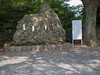
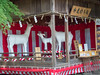
There were several chambered cairn groups, Jōyama, Mukaiyama and Zendana Kofungun, on the slope of the western mountain range of Toyokawa city, but the development of a golf link caused the destruction of them. Only cairn no. 6 of Jōyama Kofungun is moved and preserved in the sourth-western corner, beyond a bank behind the backstop of the baseball field, of the playground of Ichinomiya Junior High School (一宮中学校).
It has 2 chambers but thick weed on the mound prevents from recognizing them.
Ask for entrance permission from the teachers, and reply to the greeting from the polite baseball players.
You may be viewing yesterday's version of this page. To see the most up to date information please register for a free account.
Do not use the above information on other web sites or publications without permission of the contributor.
Nearby Images from Flickr

The above images may not be of the site on this page, but were taken nearby. They are loaded from Flickr so please click on them for image credits.
Click here to see more info for this site
Nearby sites
Click here to view sites on an interactive map of the areaKey: Red: member's photo, Blue: 3rd party photo, Yellow: other image, Green: no photo - please go there and take one, Grey: site destroyed
Download sites to:
KML (Google Earth)
GPX (GPS waypoints)
CSV (Garmin/Navman)
CSV (Excel)
To unlock full downloads you need to sign up as a Contributory Member. Otherwise downloads are limited to 50 sites.
Turn off the page maps and other distractions
Nearby sites listing. In the following links * = Image available
3.0km E 86° Hatagashirayama One Kofungun* Chambered Cairn
4.6km ESE 103° Kichijō Kofungun* Chambered Cairn
13.0km ESE 112° Makaya-ji temple* Modern Stone Circle etc
15.8km E 97° Shinradō* Hillfort
18.1km ENE 75° Mankō-ji temple* Modern Stone Circle etc
22.6km E 99° Ryōtan-ji temple (in Hamamatsu)* Modern Stone Circle etc
23.7km E 100° Jissō-ji temple* Modern Stone Circle etc
30.8km WNW 284° Futago Kofun (in Aichi)* Long Barrow
30.8km ESE 104° Nihongaya Kofungun* Chambered Cairn
31.3km W 267° Kezō-ji temple* Modern Stone Circle etc
33.6km E 93° Nekata cave* Cave or Rock Shelter
36.2km E 84° Terayama Kofungun* Chambered Cairn
42.1km ESE 115° Hōshu-ji temple* Modern Stone Circle etc
45.0km ESE 111° Iō-ji temple* Modern Stone Circle etc
55.5km WNW 298° Nagoya Port replica Moai* Modern Stone Circle etc
59.6km NW 307° Nagoya Castle* Modern Stone Circle etc
60.5km NNW 334° Kokeizan Kofungun* Chambered Cairn
62.6km N 359° Nabeyama* Standing Stones
63.4km WNW 303° Ryōun-ji temple* Modern Stone Circle etc
64.0km N 359° Shōge Kofungun* Chambered Cairn
64.7km N 355° Takenami* Standing Stones
65.6km NNW 339° Fudōdō Kofungun* Chambered Cairn
66.4km NNW 340° Mizano Kofungun* Chambered Cairn
67.0km N 353° Fuji* Standing Stones
68.1km ESE 102° Koumare-ishi* Natural Stone / Erratic / Other Natural Feature
View more nearby sites and additional images


 We would like to know more about this location. Please feel free to add a brief description and any relevant information in your own language.
 Wir möchten mehr über diese Stätte erfahren. Bitte zögern Sie nicht, eine kurze Beschreibung und relevante Informationen in Deutsch hinzuzufügen.
 Nous aimerions en savoir encore un peu sur les lieux. S'il vous plaît n'hesitez pas à ajouter une courte description et tous les renseignements pertinents dans votre propre langue.
 Quisieramos informarnos un poco más de las lugares. No dude en añadir una breve descripción y otros datos relevantes en su propio idioma.