 with our Megalithic Portal iPhone app")


<< Our Photo Pages >> Ichijōdani Asakura Family gardens - Modern Stone Circle etc in Japan in Honshū
Submitted by Aska on Sunday, 26 January 2020 Page Views: 461
Medieval (High and Late)Site Name: Ichijōdani Asakura Family gardens Alternative Name: 一乗谷朝倉氏庭園 Ichijodani Asakura-shi TeienCountry: Japan
NOTE: This site is 11.487 km away from the location you searched for.
Region: Honshū Type: Modern Stone Circle etc
Nearest Town: Fukui (Fukui prefecture) Nearest Village: Kidonouchi-chō 城戸
Latitude: 35.999160N Longitude: 136.295810E
Condition:
| 5 | Perfect |
| 4 | Almost Perfect |
| 3 | Reasonable but with some damage |
| 2 | Ruined but still recognisable as an ancient site |
| 1 | Pretty much destroyed, possibly visible as crop marks |
| 0 | No data. |
| -1 | Completely destroyed |
| 5 | Superb |
| 4 | Good |
| 3 | Ordinary |
| 2 | Not Good |
| 1 | Awful |
| 0 | No data. |
| 5 | Can be driven to, probably with disabled access |
| 4 | Short walk on a footpath |
| 3 | Requiring a bit more of a walk |
| 2 | A long walk |
| 1 | In the middle of nowhere, a nightmare to find |
| 0 | No data. |
| 5 | co-ordinates taken by GPS or official recorded co-ordinates |
| 4 | co-ordinates scaled from a detailed map |
| 3 | co-ordinates scaled from a bad map |
| 2 | co-ordinates of the nearest village |
| 1 | co-ordinates of the nearest town |
| 0 | no data |
Internal Links:
External Links:
")
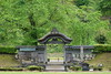
A feudal landlord ASAKURA clan set their town in a deep valley during the 14th century, and then many cultural refugees settled here escaping from Kyōto in disorder during the civil war period (late 15th – late 16th c) and this town thrived as another little Kyōto. After the battle with Nobunaga ODA (1534-1582), the great conqueror and the unifier, ASAKURA clans deserted this town. This site has been excavated since 1967. The gardens contain 4 groups of stone settings, they originally belonged to each independent houses and a temple whose buildings had been rotted away.
A museum attached. Official site of the museum in English
You may be viewing yesterday's version of this page. To see the most up to date information please register for a free account.
Do not use the above information on other web sites or publications without permission of the contributor.
Nearby Images from Flickr
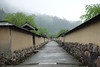
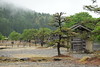
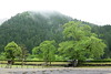
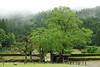
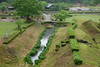
The above images may not be of the site on this page, but were taken nearby. They are loaded from Flickr so please click on them for image credits.
Click here to see more info for this site
Nearby sites
Click here to view sites on an interactive map of the areaKey: Red: member's photo, Blue: 3rd party photo, Yellow: other image, Green: no photo - please go there and take one, Grey: site destroyed
Download sites to:
KML (Google Earth)
GPX (GPS waypoints)
CSV (Garmin/Navman)
CSV (Excel)
To unlock full downloads you need to sign up as a Contributory Member. Otherwise downloads are limited to 50 sites.
Turn off the page maps and other distractions
Nearby sites listing. In the following links * = Image available
13.2km SSW 206° Jōfuku-ji temple* Modern Stone Circle etc
22.4km ENE 77° ex-Genshō-in temple* Modern Stone Circle etc
33.6km N 2° Soryō-kan* Modern Stone Circle etc
36.7km NNE 18° Nata-dera temple* Modern Stone Circle etc
44.2km SSW 195° TsubakiZaka Honjin ato* Modern Stone Circle etc
58.5km S 177° Daikichi-ji temple* Modern Stone Circle etc
58.9km S 187° Ōmori Kofun* Long Barrow
60.1km NNE 18° IshinokiZuka* Stone Circle
60.4km ESE 110° Tō Clan Residence Garden* Modern Stone Circle etc
60.7km S 178° Kohō-an temple (in Shiga prefecture)* Modern Stone Circle etc
62.2km S 188° Raigō-in temple* Modern Stone Circle etc
66.5km S 184° Anraku-ji temple* Modern Stone Circle etc
67.0km NNE 24° Okyōzuka* Ancient Village or Settlement
67.9km NNE 24° Chikamori* Timber Circle
68.2km S 172° Shicchi-in temple* Modern Stone Circle etc
68.5km S 182° Daitsū-ji temple* Modern Stone Circle etc
69.2km SSW 201° Gokuraku-ji temple* Modern Stone Circle etc
70.2km NNE 29° Tentoku-in temple (in Kanazawa)* Modern Stone Circle etc
70.3km SSW 200° Sōtaku-ji temple* Modern Stone Circle etc
72.1km S 181° Fukuden-ji temple* Modern Stone Circle etc
72.9km S 180° Raishō-ji temple* Modern Stone Circle etc
74.0km SE 138° Shinchō-ji temple* Modern Stone Circle etc
74.3km S 177° Samegai* Hillfort
74.8km SW 218° Mantoku-ji temple* Modern Stone Circle etc
75.1km SW 216° Myōtsū-ji temple* NOT SET
View more nearby sites and additional images


 We would like to know more about this location. Please feel free to add a brief description and any relevant information in your own language.
 Wir möchten mehr über diese Stätte erfahren. Bitte zögern Sie nicht, eine kurze Beschreibung und relevante Informationen in Deutsch hinzuzufügen.
 Nous aimerions en savoir encore un peu sur les lieux. S'il vous plaît n'hesitez pas à ajouter une courte description et tous les renseignements pertinents dans votre propre langue.
 Quisieramos informarnos un poco más de las lugares. No dude en añadir una breve descripción y otros datos relevantes en su propio idioma.