


<< Our Photo Pages >> Magai-butsu of Ōno-dera temple - Carving in Japan in Honshū
Submitted by Aska on Sunday, 14 January 2024 Page Views: 146
Medieval (High and Late)Site Name: Magai-butsu of Ōno-dera temple Alternative Name: 大野寺磨崖仏Country: Japan Region: Honshū Type: Carving
Nearest Town: Uda (Nara prefecture) Nearest Village: Murō-Ōno 室生ä
Latitude: 34.562260N Longitude: 136.015880E
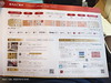
Condition:
| 5 | Perfect |
| 4 | Almost Perfect |
| 3 | Reasonable but with some damage |
| 2 | Ruined but still recognisable as an ancient site |
| 1 | Pretty much destroyed, possibly visible as crop marks |
| 0 | No data. |
| -1 | Completely destroyed |
| 5 | Superb |
| 4 | Good |
| 3 | Ordinary |
| 2 | Not Good |
| 1 | Awful |
| 0 | No data. |
| 5 | Can be driven to, probably with disabled access |
| 4 | Short walk on a footpath |
| 3 | Requiring a bit more of a walk |
| 2 | A long walk |
| 1 | In the middle of nowhere, a nightmare to find |
| 0 | No data. |
| 5 | co-ordinates taken by GPS or official recorded co-ordinates |
| 4 | co-ordinates scaled from a detailed map |
| 3 | co-ordinates scaled from a bad map |
| 2 | co-ordinates of the nearest village |
| 1 | co-ordinates of the nearest town |
| 0 | no data |
Internal Links:
External Links:
")
On the opposite bank to the precinct of Ōno-dera temple across a stream, there is a “magai-butsu” (cliff-carved Buddha, 13.8m high). It is supposed to be built during 1207-1209, as a replica of the magaibutsu of Kasagi-dera temple.
You may be viewing yesterday's version of this page. To see the most up to date information please register for a free account.
")
Do not use the above information on other web sites or publications without permission of the contributor.
Nearby Images from Flickr


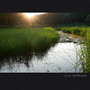
The above images may not be of the site on this page, but were taken nearby. They are loaded from Flickr so please click on them for image credits.
Click here to see more info for this site
Nearby sites
Click here to view sites on an interactive map of the areaKey: Red: member's photo, Blue: 3rd party photo, Yellow: other image, Green: no photo - please go there and take one, Grey: site destroyed
Download sites to:
KML (Google Earth)
GPX (GPS waypoints)
CSV (Garmin/Navman)
CSV (Excel)
To unlock full downloads you need to sign up as a Contributory Member. Otherwise downloads are limited to 50 sites.
Turn off the page maps and other distractions
Nearby sites listing. In the following links * = Image available
9.6km NE 46° Tōdō Family Residence garden* Modern Stone Circle etc
12.0km N 354° Nabekurakei* Natural Stone / Erratic / Other Natural Feature
12.3km NW 309° Tō-no-Mori* Ancient Temple
14.2km WSW 245° Dan-no-tsuka Kofun* Passage Grave
14.5km WSW 249° Ossaka Kofungun* Passage Grave
15.0km W 259° Gempi-an temple* Modern Stone Circle etc
15.0km W 268° Kushiyama Kofun* Long Barrow
15.6km WSW 249° Sakurai Chausuyama Kofun* Long Barrow
15.9km W 261° Hokenoyama Kofun* Long Barrow
16.1km WNW 282° Nishiyama Kofun (in Nara)* Long Barrow
16.2km W 261° Hashihaka Kofun* Long Barrow
16.3km NW 304° Shōryaku-ji temple (in Nara)* Modern Stone Circle etc
16.6km W 264° Makimuku Ishizuka Kofun* Long Barrow
16.8km WNW 283° Tenri replica Moai* Modern Stone Circle etc
18.7km NE 46° Jonokoshi* Holy Well or Sacred Spring
19.5km WSW 244° Sekijinzō* Sculptured Stone
19.5km WSW 244° Asuka Shiryōkan Museum* Museum
19.5km WSW 244° Shumisenseki* Sculptured Stone
19.8km WSW 240° Oka-no-Tateishi* Standing Stone (Menhir)
19.9km W 272° Karako Kagi* Ancient Village or Settlement
20.1km WSW 241° Kamegata-Sekizōbutsu* Sculptured Stone
20.1km WSW 241° Sakafuneishi* Sculptured Stone
20.2km WSW 238° Jōgo-no-Tateishi* Standing Stone (Menhir)
20.4km WSW 239° Ishibutai Kofun* Passage Grave
20.4km WSW 238° Miyakozuka Kofun* Passage Grave
View more nearby sites and additional images


 We would like to know more about this location. Please feel free to add a brief description and any relevant information in your own language.
 Wir möchten mehr über diese Stätte erfahren. Bitte zögern Sie nicht, eine kurze Beschreibung und relevante Informationen in Deutsch hinzuzufügen.
 Nous aimerions en savoir encore un peu sur les lieux. S'il vous plaît n'hesitez pas à ajouter une courte description et tous les renseignements pertinents dans votre propre langue.
 Quisieramos informarnos un poco más de las lugares. No dude en añadir una breve descripción y otros datos relevantes en su propio idioma.