


<< Our Photo Pages >> Yata-dera temple - Modern Stone Circle etc in Japan in Honshū
Submitted by Aska on Thursday, 13 February 2020 Page Views: 394
Modern SitesSite Name: Yata-dera temple Alternative Name: 矢田寺 金剛山寺 Kongōsen-ji Kongosenji-jiCountry: Japan
NOTE: This site is 3.932 km away from the location you searched for.
Region: Honshū Type: Modern Stone Circle etc
Nearest Town: YamatoKōriyama (Nara prefecture) Nearest Village: Yata-chō 矢田町
Latitude: 34.649490N Longitude: 135.737950E
Condition:
| 5 | Perfect |
| 4 | Almost Perfect |
| 3 | Reasonable but with some damage |
| 2 | Ruined but still recognisable as an ancient site |
| 1 | Pretty much destroyed, possibly visible as crop marks |
| 0 | No data. |
| -1 | Completely destroyed |
| 5 | Superb |
| 4 | Good |
| 3 | Ordinary |
| 2 | Not Good |
| 1 | Awful |
| 0 | No data. |
| 5 | Can be driven to, probably with disabled access |
| 4 | Short walk on a footpath |
| 3 | Requiring a bit more of a walk |
| 2 | A long walk |
| 1 | In the middle of nowhere, a nightmare to find |
| 0 | No data. |
| 5 | co-ordinates taken by GPS or official recorded co-ordinates |
| 4 | co-ordinates scaled from a detailed map |
| 3 | co-ordinates scaled from a bad map |
| 2 | co-ordinates of the nearest village |
| 1 | co-ordinates of the nearest town |
| 0 | no data |
Internal Links:
External Links:
")
Open 9:30-16:30, admission free, 700 Japanese Yen (2024 price) during Hydrangea season (June-July)
Official site in English.
You may be viewing yesterday's version of this page. To see the most up to date information please register for a free account.
Do not use the above information on other web sites or publications without permission of the contributor.
Nearby Images from Flickr
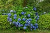


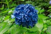
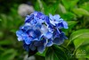
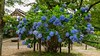
The above images may not be of the site on this page, but were taken nearby. They are loaded from Flickr so please click on them for image credits.
Click here to see more info for this site
Nearby sites
Click here to view sites on an interactive map of the areaKey: Red: member's photo, Blue: 3rd party photo, Yellow: other image, Green: no photo - please go there and take one, Grey: site destroyed
Download sites to:
KML (Google Earth)
GPX (GPS waypoints)
CSV (Garmin/Navman)
CSV (Excel)
To unlock full downloads you need to sign up as a Contributory Member. Otherwise downloads are limited to 50 sites.
Turn off the page maps and other distractions
Nearby sites listing. In the following links * = Image available
4.8km ENE 63° Bussoku-seki of Yakushi-ji temple* Carving
7.0km ENE 57° Heijō-kyō Palace garden ruin (southern garden)* Modern Stone Circle etc
7.2km NE 41° Saki Misasagiyama Kofun* Long Barrow
7.4km NE 53° Heijō-kyō Palace garden ruin (eastern garden)* Modern Stone Circle etc
8.3km WSW 248° Takayasu-no-Ki* Hillfort
9.0km W 263° Shionjiyama Kofun* Long Barrow
9.1km NNE 24° Ishi-no-Karato Kofun* Passage Grave
9.7km ENE 71° Zutō* Pyramid / Mastaba
9.9km NE 55° Hayato-ishi (in Nara)* Carving
9.9km S 181° Nagareyama Kofun* Long Barrow
10.3km W 281° Hanazono Rugby Stadium* Modern Stone Circle etc
10.5km SSE 148° Karako Kagi* Ancient Village or Settlement
10.8km ESE 123° Tenri replica Moai* Modern Stone Circle etc
11.0km S 181° Mitsuyoshi-Ishizuka Kofun* Long Barrow
11.5km ESE 123° Nishiyama Kofun (in Nara)* Long Barrow
11.9km E 93° Shōryaku-ji temple (in Nara)* Modern Stone Circle etc
12.2km SW 224° Matsuokayama Kofun* Holed Stone
12.3km SW 224° ChausuZuka Kofun* Chambered Cairn
12.5km SW 227° Takaida Yokoana* Rock Cut Tomb
13.5km NNW 328° Ishi-no-Hōden Kofun* Passage Grave
13.7km WNW 293° Kōnoike Shinden hall* Modern Stone Circle etc
13.8km SW 226° Anpuku-ji Yokoana* Rock Cut Tomb
13.9km SW 226° Anpuku-ji Sekkan* Cist
14.6km SE 142° Makimuku Ishizuka Kofun* Long Barrow
14.7km SE 135° Kushiyama Kofun* Long Barrow
View more nearby sites and additional images


 We would like to know more about this location. Please feel free to add a brief description and any relevant information in your own language.
 Wir möchten mehr über diese Stätte erfahren. Bitte zögern Sie nicht, eine kurze Beschreibung und relevante Informationen in Deutsch hinzuzufügen.
 Nous aimerions en savoir encore un peu sur les lieux. S'il vous plaît n'hesitez pas à ajouter une courte description et tous les renseignements pertinents dans votre propre langue.
 Quisieramos informarnos un poco más de las lugares. No dude en añadir una breve descripción y otros datos relevantes en su propio idioma.