


<< Our Photo Pages >> Rinshō-ji temple - Modern Stone Circle etc in Japan in Honshū
Submitted by Aska on Thursday, 13 February 2020 Page Views: 373
Modern SitesSite Name: Rinshō-ji temple Alternative Name: 林昌寺 Rinsho-jiCountry: Japan
NOTE: This site is 9.435 km away from the location you searched for.
Region: Honshū Type: Modern Stone Circle etc
Nearest Town: Sen’nan (Ōsaka prefecture) Nearest Village: Shindachi-Okanaka 信達岡中
Latitude: 34.352750N Longitude: 135.270730E
Condition:
| 5 | Perfect |
| 4 | Almost Perfect |
| 3 | Reasonable but with some damage |
| 2 | Ruined but still recognisable as an ancient site |
| 1 | Pretty much destroyed, possibly visible as crop marks |
| 0 | No data. |
| -1 | Completely destroyed |
| 5 | Superb |
| 4 | Good |
| 3 | Ordinary |
| 2 | Not Good |
| 1 | Awful |
| 0 | No data. |
| 5 | Can be driven to, probably with disabled access |
| 4 | Short walk on a footpath |
| 3 | Requiring a bit more of a walk |
| 2 | A long walk |
| 1 | In the middle of nowhere, a nightmare to find |
| 0 | No data. |
| 5 | co-ordinates taken by GPS or official recorded co-ordinates |
| 4 | co-ordinates scaled from a detailed map |
| 3 | co-ordinates scaled from a bad map |
| 2 | co-ordinates of the nearest village |
| 1 | co-ordinates of the nearest town |
| 0 | no data |
Internal Links:
External Links:
")
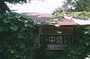
Rinshō-ji temple, only 15km away from Kansai Airport, has a dry landscape garden like a maze with stones and azalea trees designed by a modern gardener Mirei SHIGEMORI (1896-1975), built in 1961.
You may be viewing yesterday's version of this page. To see the most up to date information please register for a free account.
Do not use the above information on other web sites or publications without permission of the contributor.
Nearby Images from Flickr
The above images may not be of the site on this page, but were taken nearby. They are loaded from Flickr so please click on them for image credits.
Click here to see more info for this site
Nearby sites
Click here to view sites on an interactive map of the areaKey: Red: member's photo, Blue: 3rd party photo, Yellow: other image, Green: no photo - please go there and take one, Grey: site destroyed
Download sites to:
KML (Google Earth)
GPX (GPS waypoints)
CSV (Garmin/Navman)
CSV (Excel)
To unlock full downloads you need to sign up as a Contributory Member. Otherwise downloads are limited to 50 sites.
Turn off the page maps and other distractions
Nearby sites listing. In the following links * = Image available
13.8km SW 229° Fujito-dai residential town* Modern Stone Circle etc
14.8km ESE 123° Kokawa-dera temple* Modern Stone Circle etc
14.8km ESE 122° JūzenRitsu-in temple* Modern Stone Circle etc
14.9km NE 38° Kishiwada Castle* Modern Stone Circle etc
21.9km SSW 196° Jōkoku-ji temple* Modern Stone Circle etc
25.2km ENE 70° Mani-in temple* Modern Stone Circle etc
25.2km ENE 70° Amanōsan Kongō-ji temple* Modern Stone Circle etc
29.6km NE 48° Dotō* Pyramid / Mastaba
30.1km NE 37° Nanshū-ji temple* Modern Stone Circle etc
30.8km NE 40° Daisen Kofun* Long Barrow
32.6km WNW 301° Myōshō-ji temple* Modern Stone Circle etc
34.0km W 268° Sumoto courts* Modern Stone Circle etc
35.4km ENE 68° Kanayama Kofun* Passage Grave
37.1km NNW 326° Goshikizuka Kofun* Long Barrow
37.3km NE 52° Yachū-ji temple* Sculptured Stone
38.5km ENE 63° Koshimaezuka Kofun* Passage Grave
39.0km ENE 63° Yamada Takatsuka Kofun* Passage Grave
39.0km ENE 57° Hayato-ishi (in Ōsaka)* Carving
39.1km ENE 63° Futagozuka Kofun (in Ōsaka)* Passage Grave
39.5km NNE 31° Gansen-ji temple* Modern Stone Circle etc
39.6km E 91° Kongō-ji temple* Modern Stone Circle etc
39.9km WNW 282° Enichi-ji temple* Modern Stone Circle etc
40.3km NE 54° Anpuku-ji Sekkan* Cist
40.4km NE 54° Anpuku-ji Yokoana* Rock Cut Tomb
40.6km NE 34° Shitennō-ji temple* Ancient Temple
View more nearby sites and additional images


 We would like to know more about this location. Please feel free to add a brief description and any relevant information in your own language.
 Wir möchten mehr über diese Stätte erfahren. Bitte zögern Sie nicht, eine kurze Beschreibung und relevante Informationen in Deutsch hinzuzufügen.
 Nous aimerions en savoir encore un peu sur les lieux. S'il vous plaît n'hesitez pas à ajouter une courte description et tous les renseignements pertinents dans votre propre langue.
 Quisieramos informarnos un poco más de las lugares. No dude en añadir una breve descripción y otros datos relevantes en su propio idioma.