


<< Our Photo Pages >> Yokoyama Kofungun - Chambered Cairn in Japan in Shikoku
Submitted by Aska on Sunday, 02 March 2014 Page Views: 1807
Neolithic and Bronze AgeSite Name: Yokoyama Kofungun Alternative Name: 横山古墳群Country: Japan
NOTE: This site is 4.443 km away from the location you searched for.
Region: Shikoku Type: Chambered Cairn
Nearest Town: Ayakawa-chō (Kagawa pref.) Nearest Village: Takinomiya 滝宮
Latitude: 34.261080N Longitude: 133.902130E
Condition:
| 5 | Perfect |
| 4 | Almost Perfect |
| 3 | Reasonable but with some damage |
| 2 | Ruined but still recognisable as an ancient site |
| 1 | Pretty much destroyed, possibly visible as crop marks |
| 0 | No data. |
| -1 | Completely destroyed |
| 5 | Superb |
| 4 | Good |
| 3 | Ordinary |
| 2 | Not Good |
| 1 | Awful |
| 0 | No data. |
| 5 | Can be driven to, probably with disabled access |
| 4 | Short walk on a footpath |
| 3 | Requiring a bit more of a walk |
| 2 | A long walk |
| 1 | In the middle of nowhere, a nightmare to find |
| 0 | No data. |
| 5 | co-ordinates taken by GPS or official recorded co-ordinates |
| 4 | co-ordinates scaled from a detailed map |
| 3 | co-ordinates scaled from a bad map |
| 2 | co-ordinates of the nearest village |
| 1 | co-ordinates of the nearest town |
| 0 | no data |
Internal Links:
External Links:
")
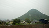
Most of them were levelled flat and are hard to recognize as artificial mounds.
The most accessible path to this site begins on the east side of the mountain, which leads to the relay station for telecommunications on the hill top.
You may be viewing yesterday's version of this page. To see the most up to date information please register for a free account.
Do not use the above information on other web sites or publications without permission of the contributor.
Nearby Images from Flickr


The above images may not be of the site on this page, but were taken nearby. They are loaded from Flickr so please click on them for image credits.
Click here to see more info for this site
Nearby sites
Click here to view sites on an interactive map of the areaKey: Red: member's photo, Blue: 3rd party photo, Yellow: other image, Green: no photo - please go there and take one, Grey: site destroyed
Download sites to:
KML (Google Earth)
GPX (GPS waypoints)
CSV (Garmin/Navman)
CSV (Excel)
To unlock full downloads you need to sign up as a Contributory Member. Otherwise downloads are limited to 50 sites.
Turn off the page maps and other distractions
Nearby sites listing. In the following links * = Image available
781m WSW 243° Jinnomaru Kofungun* Long Barrow
4.0km NNW 345° Kiyama* Hillfort
5.0km N 355° Daigo Kofungun* Passage Grave
5.1km NNW 337° Jiigamatsu Kofun* Chambered Cairn
5.2km NNW 335° Hakarigōro Kofun* Chambered Cairn
5.2km NNE 19° Yama-no-kami Kofungun* Passage Grave
5.2km NNE 22° Sagi-no-kuchi Kofun* Passage Grave
5.6km NNE 20° Ayaorizuka Kofun* Passage Grave
8.8km N 356° Men-yama Kofungun* Chambered Cairn
9.2km NW 315° Shōtsūjiyama Kofun* Chambered Cairn
10.1km N 5° Suberiyama Kofungun* Chambered Cairn
11.5km WSW 251° Suriusuyama Kofun* Passage Grave
11.7km NNE 28° Yokotateyama Kyōzuka Kofun* Chambered Cairn
11.7km WSW 241° Oka Kofungun* Passage Grave
11.8km WSW 237° Ōsayama Kyōzuka Kofun* Chambered Cairn
11.8km NNE 29° Yokotateyama Tōroku Kofungun* Chambered Cairn
11.9km SW 236° Ōsayama Wankashizuka Kofun* Chambered Cairn
13.1km WSW 244° Kawaratani Kofungun* Passage Grave
13.3km WSW 238° Notanoin Kofun* Chambered Cairn
13.7km WSW 244° Miyagao Kofun* Passage Grave
14.1km ENE 56° Iwaseoyama Kofungun* Chambered Cairn
14.8km ENE 60° Ritsurin Park* Modern Stone Circle etc
15.5km WSW 252° Ōkubo Kyōzuka Kofun* Chambered Cairn
19.6km WSW 241° Yaobikuni-tō* Ancient Temple
19.9km NE 44° Megishima replica Moai* Modern Stone Circle etc
View more nearby sites and additional images


 We would like to know more about this location. Please feel free to add a brief description and any relevant information in your own language.
 Wir möchten mehr über diese Stätte erfahren. Bitte zögern Sie nicht, eine kurze Beschreibung und relevante Informationen in Deutsch hinzuzufügen.
 Nous aimerions en savoir encore un peu sur les lieux. S'il vous plaît n'hesitez pas à ajouter une courte description et tous les renseignements pertinents dans votre propre langue.
 Quisieramos informarnos un poco más de las lugares. No dude en añadir una breve descripción y otros datos relevantes en su propio idioma.