 with our Megalithic Portal iPhone app")

<< Our Photo Pages >> Kōshōjiyama Kofungun - Passage Grave in Japan in Shikoku
Submitted by Aska on Sunday, 11 March 2012 Page Views: 2597
Rock ArtSite Name: Kōshōjiyama Kofungun Alternative Name: 興昌寺山古墳群 Koshojiyama KofungunCountry: Japan
NOTE: This site is 0.787 km away from the location you searched for.
Region: Shikoku Type: Passage Grave
Nearest Town: Kannonji (Kagawa pref.) Nearest Village: Yahata-chō 八幡町
Latitude: 34.137960N Longitude: 133.649480E
Condition:
| 5 | Perfect |
| 4 | Almost Perfect |
| 3 | Reasonable but with some damage |
| 2 | Ruined but still recognisable as an ancient site |
| 1 | Pretty much destroyed, possibly visible as crop marks |
| 0 | No data. |
| -1 | Completely destroyed |
| 5 | Superb |
| 4 | Good |
| 3 | Ordinary |
| 2 | Not Good |
| 1 | Awful |
| 0 | No data. |
| 5 | Can be driven to, probably with disabled access |
| 4 | Short walk on a footpath |
| 3 | Requiring a bit more of a walk |
| 2 | A long walk |
| 1 | In the middle of nowhere, a nightmare to find |
| 0 | No data. |
| 5 | co-ordinates taken by GPS or official recorded co-ordinates |
| 4 | co-ordinates scaled from a detailed map |
| 3 | co-ordinates scaled from a bad map |
| 2 | co-ordinates of the nearest village |
| 1 | co-ordinates of the nearest town |
| 0 | no data |
Internal Links:
External Links:
")
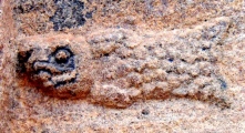
Tumulus no.1 (round shaped) lies on the top of the mountain behind Kōshō-ji (興昌寺) temple, on the route of miniature Shikoku Pilgrimage hiking trail. It has faint carvings of leaves and ships on the left walls of passage and chamber.
A huge sand sculpture of coin (銭形砂絵) in a diameter of 100m, built in 1633, lies on the sea shore nearby.
You may be viewing yesterday's version of this page. To see the most up to date information please register for a free account.
Do not use the above information on other web sites or publications without permission of the contributor.
Nearby Images from Flickr
The above images may not be of the site on this page, but were taken nearby. They are loaded from Flickr so please click on them for image credits.
Click here to see more info for this site
Nearby sites
Click here to view sites on an interactive map of the areaKey: Red: member's photo, Blue: 3rd party photo, Yellow: other image, Green: no photo - please go there and take one, Grey: site destroyed
Download sites to:
KML (Google Earth)
GPX (GPS waypoints)
CSV (Garmin/Navman)
CSV (Excel)
To unlock full downloads you need to sign up as a Contributory Member. Otherwise downloads are limited to 50 sites.
Turn off the page maps and other distractions
Nearby sites listing. In the following links * = Image available
7.4km ENE 57° Yaobikuni-tō* Ancient Temple
12.3km NE 44° Ōkubo Kyōzuka Kofun* Chambered Cairn
13.4km NE 55° Miyagao Kofun* Passage Grave
13.7km ENE 61° Notanoin Kofun* Chambered Cairn
13.9km NE 55° Kawaratani Kofungun* Passage Grave
15.1km ENE 62° Ōsayama Wankashizuka Kofun* Chambered Cairn
15.2km ENE 62° Ōsayama Kyōzuka Kofun* Chambered Cairn
15.3km ENE 59° Oka Kofungun* Passage Grave
15.8km SSW 202° Uma Mukaiyama Kofun* Long Barrow
15.9km NE 51° Suriusuyama Kofun* Passage Grave
25.3km SE 130° Myōken Jinja shrine (in Nozumi, Miyoshi city)* Stone Row / Alignment
25.9km ESE 114° Ashiro Higashihara Iseki* Chambered Cairn
26.2km ENE 59° Jinnomaru Kofungun* Long Barrow
26.2km NE 40° Shōtsūjiyama Kofun* Chambered Cairn
27.0km ENE 59° Yokoyama Kofungun* Chambered Cairn
27.9km NE 49° Hakarigōro Kofun* Chambered Cairn
28.1km NE 49° Jiigamatsu Kofun* Chambered Cairn
28.3km NE 52° Kiyama* Hillfort
29.3km ESE 116° Tanda Kofun* Chambered Cairn
29.4km NE 51° Daigo Kofungun* Passage Grave
29.7km ESE 116° Namiuchi* Standing Stones
29.8km ESE 112° Yahata Jinja shrine (in HigashiMiyoshi-chō, Tokushima pref.)* Stone Row / Alignment
31.1km NE 53° Yama-no-kami Kofungun* Passage Grave
31.3km NE 54° Sagi-no-kuchi Kofun* Passage Grave
31.4km NE 53° Ayaorizuka Kofun* Passage Grave
View more nearby sites and additional images


 We would like to know more about this location. Please feel free to add a brief description and any relevant information in your own language.
 Wir möchten mehr über diese Stätte erfahren. Bitte zögern Sie nicht, eine kurze Beschreibung und relevante Informationen in Deutsch hinzuzufügen.
 Nous aimerions en savoir encore un peu sur les lieux. S'il vous plaît n'hesitez pas à ajouter une courte description et tous les renseignements pertinents dans votre propre langue.
 Quisieramos informarnos un poco más de las lugares. No dude en añadir una breve descripción y otros datos relevantes en su propio idioma.