

<< Our Photo Pages >> Saruishi (in ex-Azuma town) - Sculptured Stone in Japan in Kyūshū
Submitted by Aska on Wednesday, 14 January 2009 Page Views: 3276
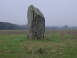
Date UncertainSite Name: Saruishi (in ex-Azuma town) Alternative Name: 吾妻猿石, 永中名猿石Country: Japan Region: Kyūshū Type: Sculptured Stone
Nearest Town: Unzen (Nagasaki pref.) Nearest Village: Azumachō-Eichūmyō 吾
Latitude: 32.828200N Longitude: 130.179570E
Condition:
| 5 | Perfect |
| 4 | Almost Perfect |
| 3 | Reasonable but with some damage |
| 2 | Ruined but still recognisable as an ancient site |
| 1 | Pretty much destroyed, possibly visible as crop marks |
| 0 | No data. |
| -1 | Completely destroyed |
| 5 | Superb |
| 4 | Good |
| 3 | Ordinary |
| 2 | Not Good |
| 1 | Awful |
| 0 | No data. |
| 5 | Can be driven to, probably with disabled access |
| 4 | Short walk on a footpath |
| 3 | Requiring a bit more of a walk |
| 2 | A long walk |
| 1 | In the middle of nowhere, a nightmare to find |
| 0 | No data. |
| 5 | co-ordinates taken by GPS or official recorded co-ordinates |
| 4 | co-ordinates scaled from a detailed map |
| 3 | co-ordinates scaled from a bad map |
| 2 | co-ordinates of the nearest village |
| 1 | co-ordinates of the nearest town |
| 0 | no data |
Internal Links:
External Links:
 (PID:44871)")
Another Saruishi in the Shimabara peninsula, at ex-Azuma town now merged into Unzen city in 2005. Moved from original position, now placed in a small shrine in a private house.
2 other Saruishi's were found in neighbouring Shimabara city, but their whereabouts are unknown.
You may be viewing yesterday's version of this page. To see the most up to date information please register for a free account.
Do not use the above information on other web sites or publications without permission of the contributor.
Nearby Images from Flickr
The above images may not be of the site on this page, but were taken nearby. They are loaded from Flickr so please click on them for image credits.
Click here to see more info for this site
Nearby sites
Click here to view sites on an interactive map of the areaKey: Red: member's photo, Blue: 3rd party photo, Yellow: other image, Green: no photo - please go there and take one, Grey: site destroyed
Download sites to:
KML (Google Earth)
GPX (GPS waypoints)
CSV (Garmin/Navman)
CSV (Excel)
To unlock full downloads you need to sign up as a Contributory Member. Otherwise downloads are limited to 50 sites.
Turn off the page maps and other distractions
Nearby sites listing. In the following links * = Image available
11.4km N 6° Izaki Burial Chamber or Dolmen
12.4km ESE 103° Kureishibaru* Stone Circle
16.0km E 91° Keikaen* Burial Chamber or Dolmen
16.5km WNW 289° Fūkandake* Burial Chamber or Dolmen
16.7km S 171° Harayama* Burial Chamber or Dolmen
17.2km SE 141° Saruishi (in ex-Arie town)* Sculptured Stone
18.8km SE 144° Miminashi Jizō* Sculptured Stone
19.8km WSW 244° Magarizaki Kofun* Chambered Cairn
20.0km SE 146° Kirishitan Shiseki Kōen* Sculptured Stone
20.1km SE 146° Myōkō Kofun Sekijin* Sculptured Stone
20.9km SE 138° Kiba Resseki-Suimon* Hillfort
21.0km SE 146° Nagata Sekijin* Sculptured Stone
21.1km SE 146° Yadonashi Jizō* Sculptured Stone
21.8km WNW 293° ex-En’yū-ji temple* Modern Stone Circle etc
22.2km SSE 147° Kumano Sekijin* Sculptured Stone
22.3km SSE 148° Enokida Sekijin* Sculptured Stone
22.8km SE 146° Nishi-Onzuka* Burial Chamber or Dolmen
30.1km WSW 251° Shinchi Chūkagai* Modern Stone Circle etc
30.6km NE 52° Manda Itsukushima Jinja shrine* Burial Chamber or Dolmen
32.9km ENE 74° Benzaiten Kofun* Passage Grave
33.0km NE 54° San-no-miya* Sculptured Stone
33.4km NE 54° Hagi-no-O Kofun* Passage Grave
33.7km ENE 72° Toshi-no-Kami* Burial Chamber or Dolmen
37.2km ENE 75° Jōgasaki* Burial Chamber or Dolmen
37.2km ENE 71° Sugawara Jinja shrine (in Tamana)* Burial Chamber or Dolmen
View more nearby sites and additional images


 We would like to know more about this location. Please feel free to add a brief description and any relevant information in your own language.
 Wir möchten mehr über diese Stätte erfahren. Bitte zögern Sie nicht, eine kurze Beschreibung und relevante Informationen in Deutsch hinzuzufügen.
 Nous aimerions en savoir encore un peu sur les lieux. S'il vous plaît n'hesitez pas à ajouter une courte description et tous les renseignements pertinents dans votre propre langue.
 Quisieramos informarnos un poco más de las lugares. No dude en añadir una breve descripción y otros datos relevantes en su propio idioma.