

<< Our Photo Pages >> Maklavun Tholos - Cairn in Croatia
Submitted by AlexHunger on Tuesday, 17 May 2005 Page Views: 14392
Neolithic and Bronze AgeSite Name: Maklavun TholosCountry: Croatia Type: Cairn
Nearest Town: Porec Nearest Village: Brajkovici
Latitude: 45.108480N Longitude: 13.752800E
Condition:
| 5 | Perfect |
| 4 | Almost Perfect |
| 3 | Reasonable but with some damage |
| 2 | Ruined but still recognisable as an ancient site |
| 1 | Pretty much destroyed, possibly visible as crop marks |
| 0 | No data. |
| -1 | Completely destroyed |
| 5 | Superb |
| 4 | Good |
| 3 | Ordinary |
| 2 | Not Good |
| 1 | Awful |
| 0 | No data. |
| 5 | Can be driven to, probably with disabled access |
| 4 | Short walk on a footpath |
| 3 | Requiring a bit more of a walk |
| 2 | A long walk |
| 1 | In the middle of nowhere, a nightmare to find |
| 0 | No data. |
| 5 | co-ordinates taken by GPS or official recorded co-ordinates |
| 4 | co-ordinates scaled from a detailed map |
| 3 | co-ordinates scaled from a bad map |
| 2 | co-ordinates of the nearest village |
| 1 | co-ordinates of the nearest town |
| 0 | no data |
Internal Links:
External Links:
")
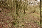
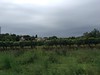
207 Meters altitude. Cairn like remains with Dromos entrance way and grave. Probably had a corbelled roof, like Newgrange, now lost. Site is seriously threatened by quarry systematically consuming the hill around it. This is creating cracks in the cliff, which could go any time, and which would completely destroy the site for ever. A rescue operation or preferably a halt to the quarrying are urgently required.
You may be viewing yesterday's version of this page. To see the most up to date information please register for a free account.
")
")
")
Do not use the above information on other web sites or publications without permission of the contributor.
Nearby Images from Flickr


The above images may not be of the site on this page, but were taken nearby. They are loaded from Flickr so please click on them for image credits.
Click here to see more info for this site
Nearby sites
Click here to view sites on an interactive map of the areaKey: Red: member's photo, Blue: 3rd party photo, Yellow: other image, Green: no photo - please go there and take one, Grey: site destroyed
Download sites to:
KML (Google Earth)
GPX (GPS waypoints)
CSV (Garmin/Navman)
CSV (Excel)
To unlock full downloads you need to sign up as a Contributory Member. Otherwise downloads are limited to 50 sites.
Turn off the page maps and other distractions
Nearby sites listing. In the following links * = Image available
1.4km W 281° Karastac Hilfort* Hillfort
6.0km SW 226° Monkodonja* Hillfort
13.2km S 181° Barbarija Tumulus 3* Round Barrow(s)
13.3km S 181° Barbarija Tumulus 2* Round Barrow(s)
13.4km S 180° Barbarija Tumulus 1* Round Barrow(s)
13.7km S 175° Uvala Maric 1* Artificial Mound
13.8km S 175° Uvala Maric 2 Tumulus* Round Barrow(s)
13.9km S 175° Uvala Maric 3 Zigurat* Artificial Mound
14.6km NW 323° Pizuge Hillfort* Hillfort
15.0km NW 319° Veliki Sveti Andeo* Hillfort
15.2km NW 320° Mali Sveti Andeo* Stone Circle
15.6km NW 322° Mordele Hillfort* Hillfort
21.4km S 177° Brijuni Museum* Museum
21.9km S 176° Brijuni Hillfort* Hillfort
24.7km SE 132° Mutvoran Hillfort* Hillfort
27.3km SE 141° Nesactium Hillfort* Hillfort
27.5km SSE 164° Pula Museum* Museum
29.2km E 95° Labin Museum* Museum
30.2km E 92° Kunci Hillfort* Hillfort
46.3km E 90° Tramuntana Portal Tomb* Portal Tomb
46.3km E 90° Tramuntana Well* Holy Well or Sacred Spring
46.9km E 89° Tramuntana Dolmen 2* Burial Chamber or Dolmen
46.9km E 89° Tramuntana Dolmen 1* Burial Chamber or Dolmen
47.2km E 89° Beli wall petroglyph* Rock Art
77.3km N 360° Debela Griža Hillfort
View more nearby sites and additional images


 We would like to know more about this location. Please feel free to add a brief description and any relevant information in your own language.
 Wir möchten mehr über diese Stätte erfahren. Bitte zögern Sie nicht, eine kurze Beschreibung und relevante Informationen in Deutsch hinzuzufügen.
 Nous aimerions en savoir encore un peu sur les lieux. S'il vous plaît n'hesitez pas à ajouter une courte description et tous les renseignements pertinents dans votre propre langue.
 Quisieramos informarnos un poco más de las lugares. No dude en añadir una breve descripción y otros datos relevantes en su propio idioma.