

<< Our Photo Pages >> Neuensien Grabhuegel 2 - Round Barrow(s) in Germany in Mecklenburg-Western Pomerania
Submitted by AlexHunger on Tuesday, 19 October 2010 Page Views: 1827
Neolithic and Bronze AgeSite Name: Neuensien Grabhuegel 2Country: Germany
NOTE: This site is 2.904 km away from the location you searched for.
Land: Mecklenburg-Western Pomerania Type: Round Barrow(s)
Nearest Town: Bergen Nearest Village: Baabe
Latitude: 54.355370N Longitude: 13.674050E
Condition:
| 5 | Perfect |
| 4 | Almost Perfect |
| 3 | Reasonable but with some damage |
| 2 | Ruined but still recognisable as an ancient site |
| 1 | Pretty much destroyed, possibly visible as crop marks |
| 0 | No data. |
| -1 | Completely destroyed |
| 5 | Superb |
| 4 | Good |
| 3 | Ordinary |
| 2 | Not Good |
| 1 | Awful |
| 0 | No data. |
| 5 | Can be driven to, probably with disabled access |
| 4 | Short walk on a footpath |
| 3 | Requiring a bit more of a walk |
| 2 | A long walk |
| 1 | In the middle of nowhere, a nightmare to find |
| 0 | No data. |
| 5 | co-ordinates taken by GPS or official recorded co-ordinates |
| 4 | co-ordinates scaled from a detailed map |
| 3 | co-ordinates scaled from a bad map |
| 2 | co-ordinates of the nearest village |
| 1 | co-ordinates of the nearest town |
| 0 | no data |
Internal Links:
External Links:
")
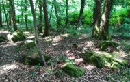
large Round barrow on the Island of Rügen measuring about 40 meters in diameer and 2 meters in height. It is directly ont he hiking / Biking path and hast park benches and is not marked as a barrow other than on the map. due to the path it appears to be in a worse condition than Neuensien Grabhügel 1.
You may be viewing yesterday's version of this page. To see the most up to date information please register for a free account.
")
")
Do not use the above information on other web sites or publications without permission of the contributor.
Nearby Images from Flickr
The above images may not be of the site on this page, but were taken nearby. They are loaded from Flickr so please click on them for image credits.
Click here to see more info for this site
Nearby sites
Click here to view sites on an interactive map of the areaKey: Red: member's photo, Blue: 3rd party photo, Yellow: other image, Green: no photo - please go there and take one, Grey: site destroyed
Download sites to:
KML (Google Earth)
GPX (GPS waypoints)
CSV (Garmin/Navman)
CSV (Excel)
To unlock full downloads you need to sign up as a Contributory Member. Otherwise downloads are limited to 50 sites.
Turn off the page maps and other distractions
Nearby sites listing. In the following links * = Image available
240m NW 314° Neuensien Grabhügel 1* Round Barrow(s)
647m NE 50° Altensien Goldbusch* Chambered Tomb
2.1km SE 134° Alt-Reddevitz Herzogsgrab* Chambered Tomb
2.5km NW 310° Garftitz Steingrab* Chambered Tomb
3.0km W 274° Preetz-Burtewitz Steingrab 1* Chambered Tomb
3.3km NW 316° Blieschow Grabhuegel 2* Round Barrow(s)
3.5km NW 315° Blieschow Grabhuegel 1* Round Barrow(s)
3.7km WNW 283° Lancken-Granitz Steingrab 4* Chambered Tomb
3.7km WNW 283° Lancken-Granitz Steingrab 3* Chambered Tomb
3.7km WNW 283° Lancken-Granitz Steingrab 2* Chambered Tomb
3.7km WNW 282° Lancken-Granitz Steingrab 1* Chambered Tomb
3.7km N 9° Schanzenort Grabhügel Round Barrow(s)
3.8km W 280° Preetz-Burtewitz Steingrab 2* Chambered Tomb
3.9km W 279° Preetz-Burtewitz Steingrab 3* Chambered Tomb
3.9km W 279° Preetz-Burtewitz Steingrab 4* Chambered Tomb
4.0km WNW 293° Lancken-Granitz Steingrab 5* Chambered Tomb
4.4km ESE 113° Speckbusch Huegelgrab* Round Barrow(s)
4.5km W 270° Gobbin Grabhuegel* Round Barrow(s)
4.6km W 271° Gobbin Ziegensteine* Long Barrow
4.6km W 270° Gobbin Steingrab 2* Chambered Tomb
5.4km E 101° Buskam Findling Natural Stone / Erratic / Other Natural Feature
6.4km NW 316° Summstein Sellin Modern Stone Circle etc
6.6km W 271° Gross Stresow Opferstein Natural Stone / Erratic / Other Natural Feature
6.7km W 275° Nistelitz Grabhuegel 1* Round Barrow(s)
6.7km W 274° Nistelitz Grabhuegel 2* Round Barrow(s)
View more nearby sites and additional images


 We would like to know more about this location. Please feel free to add a brief description and any relevant information in your own language.
 Wir möchten mehr über diese Stätte erfahren. Bitte zögern Sie nicht, eine kurze Beschreibung und relevante Informationen in Deutsch hinzuzufügen.
 Nous aimerions en savoir encore un peu sur les lieux. S'il vous plaît n'hesitez pas à ajouter une courte description et tous les renseignements pertinents dans votre propre langue.
 Quisieramos informarnos un poco más de las lugares. No dude en añadir una breve descripción y otros datos relevantes en su propio idioma.