

<< Text Pages >> Sinnhubschlössl - Ancient Village or Settlement in Austria
Submitted by KaiHofmann on Wednesday, 03 January 2018 Page Views: 890
Multi-periodSite Name: SinnhubschlösslCountry: Austria
NOTE: This site is 17.379 km away from the location you searched for.
Type: Ancient Village or Settlement
Nearest Town: St. Johann im Pongau Nearest Village: Ellmauthal
Latitude: 47.437573N Longitude: 13.209434E
Condition:
| 5 | Perfect |
| 4 | Almost Perfect |
| 3 | Reasonable but with some damage |
| 2 | Ruined but still recognisable as an ancient site |
| 1 | Pretty much destroyed, possibly visible as crop marks |
| 0 | No data. |
| -1 | Completely destroyed |
| 5 | Superb |
| 4 | Good |
| 3 | Ordinary |
| 2 | Not Good |
| 1 | Awful |
| 0 | No data. |
| 5 | Can be driven to, probably with disabled access |
| 4 | Short walk on a footpath |
| 3 | Requiring a bit more of a walk |
| 2 | A long walk |
| 1 | In the middle of nowhere, a nightmare to find |
| 0 | No data. |
| 5 | co-ordinates taken by GPS or official recorded co-ordinates |
| 4 | co-ordinates scaled from a detailed map |
| 3 | co-ordinates scaled from a bad map |
| 2 | co-ordinates of the nearest village |
| 1 | co-ordinates of the nearest town |
| 0 | no data |
Be the first person to rate this site - see the 'Contribute!' box in the right hand menu.
Internal Links:
External Links:
Ancient Village or Settlement in Austria
Neolithic/bronze age settlement on an small peninsula at the Salzach river. Some huts and copper smelting artifacts were found.
You may be viewing yesterday's version of this page. To see the most up to date information please register for a free account.
Do not use the above information on other web sites or publications without permission of the contributor.
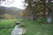
Nearby Images from Flickr
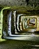
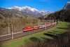
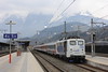

The above images may not be of the site on this page, but were taken nearby. They are loaded from Flickr so please click on them for image credits.
Click here to see more info for this site
Nearby sites
Click here to view sites on an interactive map of the areaKey: Red: member's photo, Blue: 3rd party photo, Yellow: other image, Green: no photo - please go there and take one, Grey: site destroyed
Download sites to:
KML (Google Earth)
GPX (GPS waypoints)
CSV (Garmin/Navman)
CSV (Excel)
To unlock full downloads you need to sign up as a Contributory Member. Otherwise downloads are limited to 50 sites.
Turn off the page maps and other distractions
Nearby sites listing. In the following links * = Image available
6.6km S 183° Arthurstollen Ancient Mine, Quarry or other Industry
17.7km SSW 212° Goldegger Passstelle Ancient Village or Settlement
35.2km ENE 67° Hallstatt Salt Mines* Ancient Mine, Quarry or other Industry
35.5km ENE 67° Hallstatt-Dachstein* Barrow Cemetery
35.8km ENE 67° Museum Hallstatt* Museum
40.4km NNE 32° Lugberg Rock Art
41.3km NE 36° Kienbachklamm Rock Art
41.7km SSW 198° Schalenstein Oberer Bockhartsee Rock Art
41.7km NW 319° Karlstein Celtic Settlement Ancient Village or Settlement
44.1km NNE 17° Lake Mondsee Prehistoric Village Ancient Village or Settlement
44.4km E 84° Notgasse Petroglyphen Rock Art
48.3km SW 215° Hochtor Ancient Road* Ancient Trackway
56.9km WSW 252° Hexenstein Felberturm Standing Stone (Menhir)
59.2km NNW 340° Summstein Laufen Modern Stone Circle etc
60.4km NW 315° Summstein Siegsdorf Modern Stone Circle etc
61.3km S 175° Schalenstein Danielsberg Rock Art
76.7km NW 308° Herrenchimsee Ringwall Ancient Village or Settlement
78.0km WNW 283° Tischoferhoehle* Cave or Rock Shelter
78.0km NW 321° Grabhügelfeld Stein an der Traun Barrow Cemetery
79.5km NW 317° Viereckschanze Truchtlaching* Misc. Earthwork
85.4km ENE 74° In der Höll petroglyphs Rock Art
88.8km NNW 333° Margarethenberg Hillfort
94.6km NNW 335° Station des Mesolithikums und vorgeschichtliche Siedlung Kastl Ancient Village or Settlement
94.6km NNW 334° Brandgräber der älteren Urnenfelderzeit Kastl Barrow Cemetery
94.8km NNW 334° Grabhügel Kastl 2 Round Barrow(s)
View more nearby sites and additional images


 We would like to know more about this location. Please feel free to add a brief description and any relevant information in your own language.
 Wir möchten mehr über diese Stätte erfahren. Bitte zögern Sie nicht, eine kurze Beschreibung und relevante Informationen in Deutsch hinzuzufügen.
 Nous aimerions en savoir encore un peu sur les lieux. S'il vous plaît n'hesitez pas à ajouter une courte description et tous les renseignements pertinents dans votre propre langue.
 Quisieramos informarnos un poco más de las lugares. No dude en añadir una breve descripción y otros datos relevantes en su propio idioma.