


<< Text Pages >> Wannsee Kreuz - Ancient Cross in Germany in Brandenburg, Berlin
Submitted by KaiHofmann on Thursday, 01 August 2019 Page Views: 627
Early Medieval (Dark Age)Site Name: Wannsee KreuzCountry: Germany
NOTE: This site is 8.137 km away from the location you searched for.
Land: Brandenburg, Berlin Type: Ancient Cross
Nearest Town: Berlin Nearest Village: Wannsee
Latitude: 52.419000N Longitude: 13.103000E
Condition:
| 5 | Perfect |
| 4 | Almost Perfect |
| 3 | Reasonable but with some damage |
| 2 | Ruined but still recognisable as an ancient site |
| 1 | Pretty much destroyed, possibly visible as crop marks |
| 0 | No data. |
| -1 | Completely destroyed |
| 5 | Superb |
| 4 | Good |
| 3 | Ordinary |
| 2 | Not Good |
| 1 | Awful |
| 0 | No data. |
| 5 | Can be driven to, probably with disabled access |
| 4 | Short walk on a footpath |
| 3 | Requiring a bit more of a walk |
| 2 | A long walk |
| 1 | In the middle of nowhere, a nightmare to find |
| 0 | No data. |
| 5 | co-ordinates taken by GPS or official recorded co-ordinates |
| 4 | co-ordinates scaled from a detailed map |
| 3 | co-ordinates scaled from a bad map |
| 2 | co-ordinates of the nearest village |
| 1 | co-ordinates of the nearest town |
| 0 | no data |
Internal Links:
External Links:
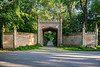
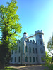
Ancient Cross in Brandenburg, Berlin
Ancient cross in the Klein-Glienicke park.
found at:
www.suehnekreuz.de
You may be viewing yesterday's version of this page. To see the most up to date information please register for a free account.
Do not use the above information on other web sites or publications without permission of the contributor.
Nearby Images from Flickr

The above images may not be of the site on this page, but were taken nearby. They are loaded from Flickr so please click on them for image credits.
Click here to see more info for this site
Nearby sites
Click here to view sites on an interactive map of the areaKey: Red: member's photo, Blue: 3rd party photo, Yellow: other image, Green: no photo - please go there and take one, Grey: site destroyed
Download sites to:
KML (Google Earth)
GPX (GPS waypoints)
CSV (Garmin/Navman)
CSV (Excel)
To unlock full downloads you need to sign up as a Contributory Member. Otherwise downloads are limited to 50 sites.
Turn off the page maps and other distractions
Nearby sites listing. In the following links * = Image available
269m W 271° Glienicker Schalenstein* Rock Art
3.7km NW 313° Koenigswall* Promontory Fort / Cliff Castle
5.2km N 7° Gross Glienicker See Natural Stone / Erratic / Other Natural Feature
11.8km NW 314° Kartzow Kreuz* Ancient Cross
12.3km NE 34° Opferaltar (sacrifice altar) Rock Art
12.8km NE 52° Findling vor Revierförsterei Eichkamp, Grünewald Natural Stone / Erratic / Other Natural Feature
13.7km NNE 29° Spandauer Burgwall Ancient Village or Settlement
16.0km NE 52° Findling Lietzensee* Natural Stone / Erratic / Other Natural Feature
16.4km NW 315° Buchow-Karpzow Fundplatz Misc. Earthwork
16.8km NNW 339° Kreisgrabenanlage Dyrotz* Henge
16.9km E 86° Elfenmuehle* Rock Art
18.8km WNW 301° Knoblauch Ringwall* Hillfort
19.8km SE 133° Grosssteingrab Loewenbruch* Burial Chamber or Dolmen
20.0km NE 56° Summstein im Englischen Garten Modern Stone Circle etc
20.2km NNE 12° Lasszinswiesen Natural Stone / Erratic / Other Natural Feature
21.3km NNE 30° Reiherwerder Opferschaechte Ancient Village or Settlement
21.3km S 182° Ringwall Koerzin* Ancient Village or Settlement
22.3km E 89° Flaezstein* Rock Art
22.7km SE 137° Eulenspiegelstein Rock Art
22.8km NNW 342° Slawenburg Alt Brieselang* Ancient Village or Settlement
22.8km ENE 60° Pergamon Museum* Museum
22.9km ENE 60° Neues Museum Berlin* Museum
22.9km ENE 61° Altes Museum Berlin* Museum
23.0km ENE 61° Berlin Museum für Vor- und Frühgeschichte Museum
23.5km ENE 61° Steinkreuz Marienkirche* Ancient Cross
View more nearby sites and additional images


 We would like to know more about this location. Please feel free to add a brief description and any relevant information in your own language.
 Wir möchten mehr über diese Stätte erfahren. Bitte zögern Sie nicht, eine kurze Beschreibung und relevante Informationen in Deutsch hinzuzufügen.
 Nous aimerions en savoir encore un peu sur les lieux. S'il vous plaît n'hesitez pas à ajouter une courte description et tous les renseignements pertinents dans votre propre langue.
 Quisieramos informarnos un poco más de las lugares. No dude en añadir una breve descripción y otros datos relevantes en su propio idioma.