 with our Megalithic Portal iPhone app")

<< Text Pages >> Riesenstein Gransee - Natural Stone / Erratic / Other Natural Feature in Germany in Brandenburg, Berlin
Submitted by KaiHofmann on Saturday, 10 May 2014 Page Views: 967
Natural PlacesSite Name: Riesenstein GranseeCountry: Germany
NOTE: This site is 5.178 km away from the location you searched for.
Land: Brandenburg, Berlin Type: Natural Stone / Erratic / Other Natural Feature
Nearest Town: Gransee Nearest Village: Badingen
Latitude: 53.005268N Longitude: 13.235947E
Condition:
| 5 | Perfect |
| 4 | Almost Perfect |
| 3 | Reasonable but with some damage |
| 2 | Ruined but still recognisable as an ancient site |
| 1 | Pretty much destroyed, possibly visible as crop marks |
| 0 | No data. |
| -1 | Completely destroyed |
| 5 | Superb |
| 4 | Good |
| 3 | Ordinary |
| 2 | Not Good |
| 1 | Awful |
| 0 | No data. |
| 5 | Can be driven to, probably with disabled access |
| 4 | Short walk on a footpath |
| 3 | Requiring a bit more of a walk |
| 2 | A long walk |
| 1 | In the middle of nowhere, a nightmare to find |
| 0 | No data. |
| 5 | co-ordinates taken by GPS or official recorded co-ordinates |
| 4 | co-ordinates scaled from a detailed map |
| 3 | co-ordinates scaled from a bad map |
| 2 | co-ordinates of the nearest village |
| 1 | co-ordinates of the nearest town |
| 0 | no data |
Be the first person to rate this site - see the 'Contribute!' box in the right hand menu.
Internal Links:
External Links:
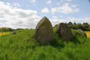
Erratic in Brandenburg, Berlin
Glacial erratic which looks like a stele. Possibly an ancient sanctuary.
You may be viewing yesterday's version of this page. To see the most up to date information please register for a free account.
Do not use the above information on other web sites or publications without permission of the contributor.
Nearby Images from Flickr
The above images may not be of the site on this page, but were taken nearby. They are loaded from Flickr so please click on them for image credits.
Click here to see more info for this site
Nearby sites
Click here to view sites on an interactive map of the areaKey: Red: member's photo, Blue: 3rd party photo, Yellow: other image, Green: no photo - please go there and take one, Grey: site destroyed
Download sites to:
KML (Google Earth)
GPX (GPS waypoints)
CSV (Garmin/Navman)
CSV (Excel)
To unlock full downloads you need to sign up as a Contributory Member. Otherwise downloads are limited to 50 sites.
Turn off the page maps and other distractions
Nearby sites listing. In the following links * = Image available
5.0km SSW 201° Fuenffingerstein (five finger stone)* Rock Art
7.5km NNW 333° Mehlsens Ruh* Burial Chamber or Dolmen
11.4km S 180° Burgwall Liebenberg Promontory Fort / Cliff Castle
13.4km NW 316° Hügelgrab Zernikow Round Barrow(s)
13.5km NW 314° Zernikow Schlitterstein* Rock Art
14.3km ENE 61° Rillenstein Hammelspring 2* Carving
15.3km N 4° Bredereicher Findlinge* Natural Stone / Erratic / Other Natural Feature
15.5km NW 324° Spukstein Natural Stone / Erratic / Other Natural Feature
15.5km ENE 60° Rillenstein Hammelspring 1* Carving
17.2km NW 319° Großsteingrab Menz* Cist
18.5km NE 56° Schälchenstein Hindenburg* Rock Art
21.6km NE 54° Hünenhacke in der Stadtmauer Templin* Ancient Mine, Quarry or other Industry
22.2km NNW 340° Hügelgräberfeld Fürstenberg* Barrow Cemetery
24.0km N 8° Hügelgräber Lychen 140346* Round Barrow(s)
24.1km N 9° Slawenburg Wurlsee* Hillfort
24.9km W 280° Schwanow Schalenstein Rock Art
25.5km NE 51° Schäferlinde Knehden Hügelgrab* Round Barrow(s)
27.6km NE 55° Opferstein Sydowshof* Natural Stone / Erratic / Other Natural Feature
27.9km S 180° Kreismuseum Oberhavel* Museum
28.1km E 91° Bärens Kirchhof* Stone Circle
28.3km NE 52° Hügelgräberfeld Klosterwalde* Barrow Cemetery
29.4km SW 232° Altfriesack Wall Ancient Village or Settlement
30.1km ENE 59° Hügelgrab Petznick 22427* Round Barrow(s)
30.1km ENE 58° Hügelgrab Petznick 22429* Round Barrow(s)
30.1km ENE 58° Hügelgrab Petznick 22428* Round Barrow(s)
View more nearby sites and additional images


 We would like to know more about this location. Please feel free to add a brief description and any relevant information in your own language.
 Wir möchten mehr über diese Stätte erfahren. Bitte zögern Sie nicht, eine kurze Beschreibung und relevante Informationen in Deutsch hinzuzufügen.
 Nous aimerions en savoir encore un peu sur les lieux. S'il vous plaît n'hesitez pas à ajouter une courte description et tous les renseignements pertinents dans votre propre langue.
 Quisieramos informarnos un poco más de las lugares. No dude en añadir una breve descripción y otros datos relevantes en su propio idioma.