
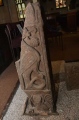

<< Our Photo Pages >> Queen Jindeog mausoleum - Round Barrow(s) in South Korea
Submitted by Aska on Monday, 13 November 2017 Page Views: 666
Neolithic and Bronze AgeSite Name: Queen Jindeog mausoleum Alternative Name: 진덕여왕릉 眞德女王陵Country: South Korea
NOTE: This site is 25.3 km away from the location you searched for.
Type: Round Barrow(s)
Nearest Town: 경주 (Gyeongju) Nearest Village: 오류리 (Oryu-ri)
Latitude: 35.887000N Longitude: 129.202000E
Condition:
| 5 | Perfect |
| 4 | Almost Perfect |
| 3 | Reasonable but with some damage |
| 2 | Ruined but still recognisable as an ancient site |
| 1 | Pretty much destroyed, possibly visible as crop marks |
| 0 | No data. |
| -1 | Completely destroyed |
| 5 | Superb |
| 4 | Good |
| 3 | Ordinary |
| 2 | Not Good |
| 1 | Awful |
| 0 | No data. |
| 5 | Can be driven to, probably with disabled access |
| 4 | Short walk on a footpath |
| 3 | Requiring a bit more of a walk |
| 2 | A long walk |
| 1 | In the middle of nowhere, a nightmare to find |
| 0 | No data. |
| 5 | co-ordinates taken by GPS or official recorded co-ordinates |
| 4 | co-ordinates scaled from a detailed map |
| 3 | co-ordinates scaled from a bad map |
| 2 | co-ordinates of the nearest village |
| 1 | co-ordinates of the nearest town |
| 0 | no data |
Internal Links:
External Links:
")
Designated as No. 24 of National Historical Heritage
You may be viewing yesterday's version of this page. To see the most up to date information please register for a free account.
")
")
Do not use the above information on other web sites or publications without permission of the contributor.
Nearby Images from Flickr


The above images may not be of the site on this page, but were taken nearby. They are loaded from Flickr so please click on them for image credits.
Click here to see more info for this site
Nearby sites
Click here to view sites on an interactive map of the areaKey: Red: member's photo, Blue: 3rd party photo, Yellow: other image, Green: no photo - please go there and take one, Grey: site destroyed
Download sites to:
KML (Google Earth)
GPX (GPS waypoints)
CSV (Garmin/Navman)
CSV (Excel)
To unlock full downloads you need to sign up as a Contributory Member. Otherwise downloads are limited to 50 sites.
Turn off the page maps and other distractions
Nearby sites listing. In the following links * = Image available
3.0km S 182° Seokjang-dong petroglyph* Rock Art
4.7km SSW 192° General Gim Yusin tomb* Round Barrow(s)
5.9km SSE 152° Kuhwang-dong stone pillars* Sculptured Stone
6.0km SSE 151° Bunhwang-sa temple* Ancient Temple
6.0km SSE 165° CheomSongDae* Broch or Nuraghe
6.1km SE 142° King Heondeog mausoleum* Round Barrow(s)
6.3km SSE 162° Wolseong castle* Ancient Palace
6.3km SSE 158° Wolji* Ancient Palace
6.5km SSE 169° Gyodong sokdap* Ancient Temple
6.8km SSE 160° Gyeongju National Museum* Museum
7.0km S 190° King Muyeol mausoleum* Barrow Cemetery
7.1km SSE 149° Hwangbok-sa temple* Ancient Temple
7.2km SE 133° Myeonghwal Sanseong* Hillfort
7.6km SSE 153° Neungji-tap* Pyramid / Mastaba
7.9km SSE 153° Queen Seongdeok mausoleum* Round Barrow(s)
9.0km S 174° Poseokjeong* Sculptured Stone
12.9km S 179° Yangjang-ri dolmen* Burial Chamber or Dolmen
13.2km SSE 147° King Seongdeog mausoleum* Round Barrow(s)
13.4km E 93° Mujang-sa temple* Ancient Temple
13.9km S 186° King Gyeongdeog mausoleum* Round Barrow(s)
14.7km N 2° King Heundeog mausoleum* Round Barrow(s)
14.8km SE 145° Gujeong-dong BanghyeonGubun* Barrow Cemetery
16.8km S 189° Ansim-ni petroglyph* NOT SET
17.1km NNE 13° 인이동 Burial Chamber or Dolmen
17.7km SE 143° King Wonseong mausoleum* Round Barrow(s)
View more nearby sites and additional images


 We would like to know more about this location. Please feel free to add a brief description and any relevant information in your own language.
 Wir möchten mehr über diese Stätte erfahren. Bitte zögern Sie nicht, eine kurze Beschreibung und relevante Informationen in Deutsch hinzuzufügen.
 Nous aimerions en savoir encore un peu sur les lieux. S'il vous plaît n'hesitez pas à ajouter une courte description et tous les renseignements pertinents dans votre propre langue.
 Quisieramos informarnos un poco más de las lugares. No dude en añadir una breve descripción y otros datos relevantes en su propio idioma.