


<< Our Photo Pages >> Usumē Hāmē - Standing Stones in Japan in Kyūshū
Submitted by Aska on Sunday, 11 February 2018 Page Views: 1325
Date UncertainSite Name: Usumē Hāmē Alternative Name: ウスメー・ハーメー Usume HameCountry: Japan Region: Kyūshū Type: Standing Stones
Nearest Town: Uruma (Okinawa pref.) Nearest Village: Ikei-jima island 伊計島
Latitude: 26.384000N Longitude: 127.993700E
Condition:
| 5 | Perfect |
| 4 | Almost Perfect |
| 3 | Reasonable but with some damage |
| 2 | Ruined but still recognisable as an ancient site |
| 1 | Pretty much destroyed, possibly visible as crop marks |
| 0 | No data. |
| -1 | Completely destroyed |
| 5 | Superb |
| 4 | Good |
| 3 | Ordinary |
| 2 | Not Good |
| 1 | Awful |
| 0 | No data. |
| 5 | Can be driven to, probably with disabled access |
| 4 | Short walk on a footpath |
| 3 | Requiring a bit more of a walk |
| 2 | A long walk |
| 1 | In the middle of nowhere, a nightmare to find |
| 0 | No data. |
| 5 | co-ordinates taken by GPS or official recorded co-ordinates |
| 4 | co-ordinates scaled from a detailed map |
| 3 | co-ordinates scaled from a bad map |
| 2 | co-ordinates of the nearest village |
| 1 | co-ordinates of the nearest town |
| 0 | no data |
Internal Links:
External Links:
")
On a lawn ground near a shore of Ikei-jima island which is connected to Okinawa main island by the chain of bridges, there stands a pair of coral limestone menhir. In the same ground also stands a worn out stone-lion "Sīsī"."Usumē" means 'old man' and "Hāmē" means 'old woman' in Okinawan language. They sometimes called as "Usumēgwa Hāmēgwa", "-gwa" is a suffix for 'little lovely one' like "-chan" in Japanese or "-y" in English (= Johnny, granny).
You may be viewing yesterday's version of this page. To see the most up to date information please register for a free account.
")
Do not use the above information on other web sites or publications without permission of the contributor.
Nearby Images from Flickr
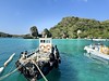


The above images may not be of the site on this page, but were taken nearby. They are loaded from Flickr so please click on them for image credits.
Click here to see more info for this site
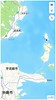
Nearby sites
Click here to view sites on an interactive map of the areaKey: Red: member's photo, Blue: 3rd party photo, Yellow: other image, Green: no photo - please go there and take one, Grey: site destroyed
Download sites to:
KML (Google Earth)
GPX (GPS waypoints)
CSV (Garmin/Navman)
CSV (Excel)
To unlock full downloads you need to sign up as a Contributory Member. Otherwise downloads are limited to 50 sites.
Turn off the page maps and other distractions
Nearby sites listing. In the following links * = Image available
2.7km SSW 200° Uehara Hītachī* Misc. Earthwork
12.9km WSW 243° Katsuren-jō* Hillfort
14.3km W 269° Agena-jō* Hillfort
16.3km W 267° Kanekadan Jōmīchā-baka* Rock Cut Tomb
18.2km WNW 284° Iha Nūru-baka* Rock Cut Tomb
18.3km W 263° Tomb of UniUfugushiku* Rock Cut Tomb
22.2km WSW 240° Nakagusuku-jō* Hillfort
22.5km WSW 251° Tōbaru cave* Cave or Rock Shelter
22.7km WSW 245° Tomb of Nakagusuku Wakamatsu* Rock Cut Tomb
23.2km WSW 236° YagiBishi-no Ibi* Standing Stones
25.0km W 261° Tomb of Noguni Sōkan* Rock Cut Tomb
25.2km W 276° Zakimi-jō* Hillfort
29.0km WSW 242° Oroku-baka* Rock Cut Tomb
30.2km WSW 240° Urasoe-jō* Hillfort
30.4km WSW 242° Iso-no-Takauhaka* Rock Cut Tomb
30.6km SW 220° Futchā-ishi* Standing Stone (Menhir)
30.7km SW 216° Tomb of Chinen Aji* Rock Cut Tomb
30.8km SW 216° Chinen-jō* Hillfort
30.9km WSW 238° Tomb of Tamagusuku Chōkun* Chambered Tomb
31.6km SW 236° Tomb of Yuntanza branch royal family* Chambered Tomb
31.6km SW 234° Hitatimō* Natural Stone / Erratic / Other Natural Feature
32.0km WSW 237° Tomb of Ie branch royal family* Chambered Tomb
32.0km SW 220° Sashiki Yōdore* Chambered Tomb
32.2km WSW 239° Tomb of Urasoe branch royal family* Chambered Tomb
32.2km SW 233° Tomb of Mabuni branch royal family* Chambered Tomb
View more nearby sites and additional images


 We would like to know more about this location. Please feel free to add a brief description and any relevant information in your own language.
 Wir möchten mehr über diese Stätte erfahren. Bitte zögern Sie nicht, eine kurze Beschreibung und relevante Informationen in Deutsch hinzuzufügen.
 Nous aimerions en savoir encore un peu sur les lieux. S'il vous plaît n'hesitez pas à ajouter une courte description et tous les renseignements pertinents dans votre propre langue.
 Quisieramos informarnos un poco más de las lugares. No dude en añadir una breve descripción y otros datos relevantes en su propio idioma.