


<< Our Photo Pages >> Shuri-jō - Hillfort in Japan in Kyūshū
Submitted by Aska on Sunday, 10 April 2016 Page Views: 1251
Medieval (High and Late)Site Name: Shuri-jō Alternative Name: 首里城 Shuri-joCountry: Japan Region: Kyūshū Type: Hillfort
Nearest Town: Naha (Okinawa pref.) Nearest Village: Shuri-Tōnokurachō 首%
Latitude: 26.216460N Longitude: 127.719260E
Condition:
| 5 | Perfect |
| 4 | Almost Perfect |
| 3 | Reasonable but with some damage |
| 2 | Ruined but still recognisable as an ancient site |
| 1 | Pretty much destroyed, possibly visible as crop marks |
| 0 | No data. |
| -1 | Completely destroyed |
| 5 | Superb |
| 4 | Good |
| 3 | Ordinary |
| 2 | Not Good |
| 1 | Awful |
| 0 | No data. |
| 5 | Can be driven to, probably with disabled access |
| 4 | Short walk on a footpath |
| 3 | Requiring a bit more of a walk |
| 2 | A long walk |
| 1 | In the middle of nowhere, a nightmare to find |
| 0 | No data. |
| 5 | co-ordinates taken by GPS or official recorded co-ordinates |
| 4 | co-ordinates scaled from a detailed map |
| 3 | co-ordinates scaled from a bad map |
| 2 | co-ordinates of the nearest village |
| 1 | co-ordinates of the nearest town |
| 0 | no data |
Internal Links:
External Links:
I have visited· I would like to visit
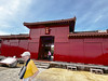
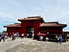
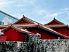
sirius_b visited on 22nd Oct 2019 - their rating: Cond: 2 Amb: 5 Access: 5 main buildings destroyed by fire in October 2019. Will be reconstructed but this will take years. See e.g. https://en.wikipedia.org/wiki/Shuri_Castle#2019_fire. A tragic loss, it had taken decades to re-build it after the destruction during WWII. We were lucky to visit it just days before the fire – one of the most spectacular reconstructions I have ever seen.
")
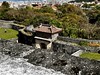
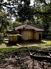
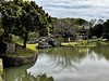
Surrounded by stone walls like other Gusuku hillforts on the Okinawan islands, it contains fine gardens.
Admission 820 Japanese yen, open 8:00-19:00 (closing time varies by seasons), closed on the 1st wednesday and thursday in July. The official site in English.
You may be viewing yesterday's version of this page. To see the most up to date information please register for a free account.
")
")
")
")
Do not use the above information on other web sites or publications without permission of the contributor.
Nearby Images from Flickr
The above images may not be of the site on this page, but were taken nearby. They are loaded from Flickr so please click on them for image credits.
Click here to see more info for this site
Nearby sites
Click here to view sites on an interactive map of the areaKey: Red: member's photo, Blue: 3rd party photo, Yellow: other image, Green: no photo - please go there and take one, Grey: site destroyed
Download sites to:
KML (Google Earth)
GPX (GPS waypoints)
CSV (Garmin/Navman)
CSV (Excel)
To unlock full downloads you need to sign up as a Contributory Member. Otherwise downloads are limited to 50 sites.
Turn off the page maps and other distractions
Nearby sites listing. In the following links * = Image available
307m NE 49° Banshō-in temple* Modern Stone Circle etc
493m WNW 293° Tama Udun* Chambered Tomb
703m SW 223° Tomb of Takushi Uēkata* Chambered Tomb
1.2km NNE 31° Tomb of Ie branch royal family* Chambered Tomb
1.5km NE 52° Tomb of Yuntanza branch royal family* Chambered Tomb
1.7km E 83° Hitatimō* Natural Stone / Erratic / Other Natural Feature
1.7km NNW 337° Tomb of Ginowan branch royal family* Chambered Tomb
2.0km ESE 117° Tomb of Mabuni branch royal family* Chambered Tomb
2.2km N 352° Tomb of Urasoe branch royal family* Chambered Tomb
2.6km NNE 24° Tomb of Tamagusuku Chōkun* Chambered Tomb
2.7km NW 305° Mekaru necropolis* Chambered Tomb
3.4km W 272° Tomb of Tokashiki Sanrā* Chambered Tomb
3.7km NNE 20° Urasoe-jō* Hillfort
4.3km N 8° Iso-no-Takauhaka* Rock Cut Tomb
4.9km WSW 249° Yamashita-chō cave* Cave or Rock Shelter
5.2km NNE 21° Oroku-baka* Rock Cut Tomb
7.0km SE 140° Tomb of Ufugusuku Aji* Chambered Tomb
7.2km WSW 240° Gushi Hitati* Natural Stone / Erratic / Other Natural Feature
8.4km SSE 149° Itokazu-jō* Hillfort
8.7km SSE 162° Sakitari-dō cave* Cave or Rock Shelter
9.2km SE 131° Sashiki Yōdore* Chambered Tomb
9.3km ESE 122° Futchā-ishi* Standing Stone (Menhir)
9.9km NE 55° YagiBishi-no Ibi* Standing Stones
10.1km SE 143° Tamagusuku-jō* Hillfort
10.5km SSE 157° Minatogawa fissure* Cave or Rock Shelter
View more nearby sites and additional images


 We would like to know more about this location. Please feel free to add a brief description and any relevant information in your own language.
 Wir möchten mehr über diese Stätte erfahren. Bitte zögern Sie nicht, eine kurze Beschreibung und relevante Informationen in Deutsch hinzuzufügen.
 Nous aimerions en savoir encore un peu sur les lieux. S'il vous plaît n'hesitez pas à ajouter une courte description et tous les renseignements pertinents dans votre propre langue.
 Quisieramos informarnos un poco más de las lugares. No dude en añadir una breve descripción y otros datos relevantes en su propio idioma.