 with our Megalithic Portal iPhone app")


<< Our Photo Pages >> Tama Udun - Chambered Tomb in Japan in Kyūshū
Submitted by Aska on Sunday, 10 April 2016 Page Views: 1575
Modern SitesSite Name: Tama Udun Alternative Name: 玉陵Country: Japan Region: Kyūshū Type: Chambered Tomb
Nearest Town: Naha (Okinawa pref.) Nearest Village: Shuri-Kinjōchō 首里
Latitude: 26.218220N Longitude: 127.714720E
Condition:
| 5 | Perfect |
| 4 | Almost Perfect |
| 3 | Reasonable but with some damage |
| 2 | Ruined but still recognisable as an ancient site |
| 1 | Pretty much destroyed, possibly visible as crop marks |
| 0 | No data. |
| -1 | Completely destroyed |
| 5 | Superb |
| 4 | Good |
| 3 | Ordinary |
| 2 | Not Good |
| 1 | Awful |
| 0 | No data. |
| 5 | Can be driven to, probably with disabled access |
| 4 | Short walk on a footpath |
| 3 | Requiring a bit more of a walk |
| 2 | A long walk |
| 1 | In the middle of nowhere, a nightmare to find |
| 0 | No data. |
| 5 | co-ordinates taken by GPS or official recorded co-ordinates |
| 4 | co-ordinates scaled from a detailed map |
| 3 | co-ordinates scaled from a bad map |
| 2 | co-ordinates of the nearest village |
| 1 | co-ordinates of the nearest town |
| 0 | no data |
Internal Links:
External Links:
I have visited· I would like to visit
sirius_b visited on 0th Oct 2019 - their rating: Cond: 5 Amb: 4 Access: 5
")
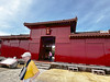
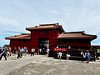
A UNESCO World Heritage. The mausoleum of the royal family of the Ryūkyū (=Okinawan) Kingdom. It contains 3 chambers, the eastern chamber stores the ornamented urns (shrine) of kings and queens, the western one stores the urns of other clans and the central one is a temporary storage of a dead body until it decay into bones. Surrounded by double gate walls and 2 gargoyle-like animals on the top. Almost demolished by the Okinawan battle during the World War II, reconstructed during 1974-1977.
Admission 300 Japanese Yen, open 9:00-18:00 all year long.
You may be viewing yesterday's version of this page. To see the most up to date information please register for a free account.
")
")
Do not use the above information on other web sites or publications without permission of the contributor.
Nearby Images from Flickr
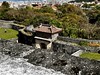
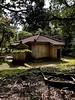
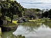
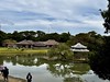
The above images may not be of the site on this page, but were taken nearby. They are loaded from Flickr so please click on them for image credits.
Click here to see more info for this site
Nearby sites
Click here to view sites on an interactive map of the areaKey: Red: member's photo, Blue: 3rd party photo, Yellow: other image, Green: no photo - please go there and take one, Grey: site destroyed
Download sites to:
KML (Google Earth)
GPX (GPS waypoints)
CSV (Garmin/Navman)
CSV (Excel)
To unlock full downloads you need to sign up as a Contributory Member. Otherwise downloads are limited to 50 sites.
Turn off the page maps and other distractions
Nearby sites listing. In the following links * = Image available
493m ESE 113° Shuri-jō* Hillfort
685m E 90° Banshō-in temple* Modern Stone Circle etc
709m S 182° Tomb of Takushi Uēkata* Chambered Tomb
1.4km N 351° Tomb of Ginowan branch royal family* Chambered Tomb
1.4km NE 52° Tomb of Ie branch royal family* Chambered Tomb
1.8km ENE 65° Tomb of Yuntanza branch royal family* Chambered Tomb
2.0km N 4° Tomb of Urasoe branch royal family* Chambered Tomb
2.1km E 90° Hitatimō* Natural Stone / Erratic / Other Natural Feature
2.2km NW 308° Mekaru necropolis* Chambered Tomb
2.5km ESE 117° Tomb of Mabuni branch royal family* Chambered Tomb
2.7km NE 35° Tomb of Tamagusuku Chōkun* Chambered Tomb
2.9km W 269° Tomb of Tokashiki Sanrā* Chambered Tomb
3.7km NNE 27° Urasoe-jō* Hillfort
4.2km NNE 14° Iso-no-Takauhaka* Rock Cut Tomb
4.6km WSW 245° Yamashita-chō cave* Cave or Rock Shelter
5.2km NNE 26° Oroku-baka* Rock Cut Tomb
6.9km WSW 237° Gushi Hitati* Natural Stone / Erratic / Other Natural Feature
7.5km SE 138° Tomb of Ufugusuku Aji* Chambered Tomb
8.9km SSE 147° Itokazu-jō* Hillfort
9.1km SSE 159° Sakitari-dō cave* Cave or Rock Shelter
9.6km SE 130° Sashiki Yōdore* Chambered Tomb
9.8km ESE 122° Futchā-ishi* Standing Stone (Menhir)
10.2km ENE 57° YagiBishi-no Ibi* Standing Stones
10.5km SE 141° Tamagusuku-jō* Hillfort
10.8km SSE 155° Minatogawa fissure* Cave or Rock Shelter
View more nearby sites and additional images


 We would like to know more about this location. Please feel free to add a brief description and any relevant information in your own language.
 Wir möchten mehr über diese Stätte erfahren. Bitte zögern Sie nicht, eine kurze Beschreibung und relevante Informationen in Deutsch hinzuzufügen.
 Nous aimerions en savoir encore un peu sur les lieux. S'il vous plaît n'hesitez pas à ajouter une courte description et tous les renseignements pertinents dans votre propre langue.
 Quisieramos informarnos un poco más de las lugares. No dude en añadir una breve descripción y otros datos relevantes en su propio idioma.