


<< Our Photo Pages >> MongchonToseong - Hillfort in South Korea
Submitted by Aska on Tuesday, 16 October 2018 Page Views: 884
Iron Age and Later PrehistorySite Name: MongchonToseong Alternative Name: 몽촌토성 夢村土城Country: South Korea
NOTE: This site is 0.753 km away from the location you searched for.
Type: Hillfort
Nearest Town: Seoul city, Songpa-gu Nearest Village: Bangi-dong (방이동)
Latitude: 37.516860N Longitude: 127.119480E
Condition:
| 5 | Perfect |
| 4 | Almost Perfect |
| 3 | Reasonable but with some damage |
| 2 | Ruined but still recognisable as an ancient site |
| 1 | Pretty much destroyed, possibly visible as crop marks |
| 0 | No data. |
| -1 | Completely destroyed |
| 5 | Superb |
| 4 | Good |
| 3 | Ordinary |
| 2 | Not Good |
| 1 | Awful |
| 0 | No data. |
| 5 | Can be driven to, probably with disabled access |
| 4 | Short walk on a footpath |
| 3 | Requiring a bit more of a walk |
| 2 | A long walk |
| 1 | In the middle of nowhere, a nightmare to find |
| 0 | No data. |
| 5 | co-ordinates taken by GPS or official recorded co-ordinates |
| 4 | co-ordinates scaled from a detailed map |
| 3 | co-ordinates scaled from a bad map |
| 2 | co-ordinates of the nearest village |
| 1 | co-ordinates of the nearest town |
| 0 | no data |
Internal Links:
External Links:
")
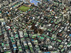
An earthen citadel constructed from several natural hills with the gap-filling augmentation of soil. Circumference 2,285m, inside area 216,000m2.
When this area was designated for the venue for the 1988 Seoul Olympic games, the first full-scale excavation was carried out as a result numerous discoveries saw the light of the day : ruins of residences, store pits, burial facilities. holes for wooden fence and artifacts showing the interaction between China and Japan.
At the northeastern point of this site (37.52406N,127.12435E), there stands a historical museum.
The area around this site has been developed into an Olympic commemoration park, crowded with Seoul citizens.
You may be viewing yesterday's version of this page. To see the most up to date information please register for a free account.
")
")
Do not use the above information on other web sites or publications without permission of the contributor.
Nearby Images from Flickr
The above images may not be of the site on this page, but were taken nearby. They are loaded from Flickr so please click on them for image credits.
Click here to see more info for this site
Nearby sites
Click here to view sites on an interactive map of the areaKey: Red: member's photo, Blue: 3rd party photo, Yellow: other image, Green: no photo - please go there and take one, Grey: site destroyed
Download sites to:
KML (Google Earth)
GPX (GPS waypoints)
CSV (Garmin/Navman)
CSV (Excel)
To unlock full downloads you need to sign up as a Contributory Member. Otherwise downloads are limited to 50 sites.
Turn off the page maps and other distractions
Nearby sites listing. In the following links * = Image available
1.0km S 186° Bangi-dong gobungun* Round Barrow(s)
2.1km SW 225° Seokchon-dong gobungun* Chambered Cairn
2.5km N 4° BungnapToseong* Hillfort
4.5km NNW 343° AchasanSeong* Hillfort
5.2km NNE 12° Seoul Amsa-dong prehistoric Sites* Ancient Village or Settlement
7.0km SE 124° NamhanSanseong* Hillfort
7.6km SSW 205° 수송리 Burial Chamber or Dolmen
12.3km W 274° National Museum of Korea* Museum
16.1km S 176° 양구리 Burial Chamber or Dolmen
18.7km ESE 118° 상자포리 Burial Chamber or Dolmen
20.7km N 2° 가락동 Burial Chamber or Dolmen
25.2km WSW 245° Gahakdong dolmens* Burial Chamber or Dolmen
30.1km SSW 201° 조부리 Burial Chamber or Dolmen
31.1km NNW 328° 역삼동 Burial Chamber or Dolmen
33.4km ESE 111° 후남리 Burial Chamber or Dolmen
52.3km WNW 294° GoJeong-ri dolmens* Burial Chamber or Dolmen
53.1km ESE 110° Seogu-ri Menhir* Standing Stone (Menhir)
55.7km SE 129° Cheo-ri Menhir* Standing Stone (Menhir)
62.1km WNW 296° Daesan-ni goindol* Burial Chamber or Dolmen
66.0km WNW 293° Gocheon-ni goindolgun* Burial Chamber or Dolmen
66.1km WNW 296° Bugeun-ni goindolgun* Burial Chamber or Dolmen
66.5km WNW 296° Gang-hwa goindolgun* Burial Chamber or Dolmen
66.8km WNW 293° Samgeo-ri goindolgun* Burial Chamber or Dolmen
67.1km WNW 295° Bugeun-ni Jeomgol goindol* Burial Chamber or Dolmen
67.5km WNW 291° Osang-ri Dolmens* Burial Chamber or Dolmen
View more nearby sites and additional images


 We would like to know more about this location. Please feel free to add a brief description and any relevant information in your own language.
 Wir möchten mehr über diese Stätte erfahren. Bitte zögern Sie nicht, eine kurze Beschreibung und relevante Informationen in Deutsch hinzuzufügen.
 Nous aimerions en savoir encore un peu sur les lieux. S'il vous plaît n'hesitez pas à ajouter une courte description et tous les renseignements pertinents dans votre propre langue.
 Quisieramos informarnos un poco más de las lugares. No dude en añadir una breve descripción y otros datos relevantes en su propio idioma.