

<< Our Photo Pages >> AchasanSeong - Hillfort in South Korea
Submitted by Aska on Sunday, 14 October 2018 Page Views: 1236
Iron Age and Later PrehistorySite Name: AchasanSeong Alternative Name: 아차산성 阿且山城, Adansanseong 아단1Country: South Korea
NOTE: This site is 4.988 km away from the location you searched for.
Type: Hillfort
Nearest Town: Seoul city, Gwangjin-gu Nearest Village: Gwanjang-dong (관장동)
Latitude: 37.555900N Longitude: 127.104470E
Condition:
| 5 | Perfect |
| 4 | Almost Perfect |
| 3 | Reasonable but with some damage |
| 2 | Ruined but still recognisable as an ancient site |
| 1 | Pretty much destroyed, possibly visible as crop marks |
| 0 | No data. |
| -1 | Completely destroyed |
| 5 | Superb |
| 4 | Good |
| 3 | Ordinary |
| 2 | Not Good |
| 1 | Awful |
| 0 | No data. |
| 5 | Can be driven to, probably with disabled access |
| 4 | Short walk on a footpath |
| 3 | Requiring a bit more of a walk |
| 2 | A long walk |
| 1 | In the middle of nowhere, a nightmare to find |
| 0 | No data. |
| 5 | co-ordinates taken by GPS or official recorded co-ordinates |
| 4 | co-ordinates scaled from a detailed map |
| 3 | co-ordinates scaled from a bad map |
| 2 | co-ordinates of the nearest village |
| 1 | co-ordinates of the nearest town |
| 0 | no data |
Internal Links:
External Links:
")
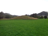
On the slope of Mt. AchaSan (아차산 峨嵯山, 283m alt.), there lies a hillfort at 200m alt. point. This is believed to be the AdanSan (아단산) fortress where the King Gaero (개로왕 蓋鹵王) of Baekje kingdom was executed by the aggression Goguryeo kingdom army in 475 CE, as the result Baekje abandoned the capital Seoul and relocated at Ungjin (nowadays Gongju (공주) city)).
Originally this fortress is called AdanSan (阿旦山), the miss spelling of Chinese character caused the alteration of the name; AchaSan (阿且山), and now another characters of the same pronunciation 峨嵯山 have applied.
The fortress surrounds a mountain ridge for 1000m but now is surrounded by the modern fence and it difficult to observe the details of the rock piled wall.
The shortcut path to this site begins at 37.55178 N, 127.10329 E but rather monotonous, another approach Mt. AchaSan trekking path (begins at 37.55276 N, 127.09962 E) contains beautiful valley, cascade and the great distant view of the Seoul city, is very enjoyable and crowded Seoul citizen.
You may be viewing yesterday's version of this page. To see the most up to date information please register for a free account.
Do not use the above information on other web sites or publications without permission of the contributor.
Nearby Images from Flickr


The above images may not be of the site on this page, but were taken nearby. They are loaded from Flickr so please click on them for image credits.
Click here to see more info for this site
Nearby sites
Click here to view sites on an interactive map of the areaKey: Red: member's photo, Blue: 3rd party photo, Yellow: other image, Green: no photo - please go there and take one, Grey: site destroyed
Download sites to:
KML (Google Earth)
GPX (GPS waypoints)
CSV (Garmin/Navman)
CSV (Excel)
To unlock full downloads you need to sign up as a Contributory Member. Otherwise downloads are limited to 50 sites.
Turn off the page maps and other distractions
Nearby sites listing. In the following links * = Image available
2.4km SE 141° BungnapToseong* Hillfort
2.5km ENE 73° Seoul Amsa-dong prehistoric Sites* Ancient Village or Settlement
4.5km SSE 163° MongchonToseong* Hillfort
5.5km SSE 167° Bangi-dong gobungun* Round Barrow(s)
5.8km S 182° Seokchon-dong gobungun* Chambered Cairn
10.9km SE 139° NamhanSanseong* Hillfort
11.3km S 190° 수송리 Burial Chamber or Dolmen
11.5km WSW 252° National Museum of Korea* Museum
16.4km N 8° 가락동 Burial Chamber or Dolmen
20.6km S 173° 양구리 Burial Chamber or Dolmen
22.1km SE 126° 상자포리 Burial Chamber or Dolmen
26.3km SW 235° Gahakdong dolmens* Burial Chamber or Dolmen
26.8km NW 326° 역삼동 Burial Chamber or Dolmen
33.8km SSW 197° 조부리 Burial Chamber or Dolmen
36.4km ESE 117° 후남리 Burial Chamber or Dolmen
49.4km WNW 290° GoJeong-ri dolmens* Burial Chamber or Dolmen
55.9km ESE 113° Seogu-ri Menhir* Standing Stone (Menhir)
59.1km WNW 293° Daesan-ni goindol* Burial Chamber or Dolmen
59.5km SE 131° Cheo-ri Menhir* Standing Stone (Menhir)
63.1km WNW 293° Bugeun-ni goindolgun* Burial Chamber or Dolmen
63.2km WNW 289° Gocheon-ni goindolgun* Burial Chamber or Dolmen
63.5km WNW 293° Gang-hwa goindolgun* Burial Chamber or Dolmen
63.9km WNW 290° Samgeo-ri goindolgun* Burial Chamber or Dolmen
64.2km WNW 292° Bugeun-ni Jeomgol goindol* Burial Chamber or Dolmen
64.6km NNE 17° 양수리 Burial Chamber or Dolmen
View more nearby sites and additional images


 We would like to know more about this location. Please feel free to add a brief description and any relevant information in your own language.
 Wir möchten mehr über diese Stätte erfahren. Bitte zögern Sie nicht, eine kurze Beschreibung und relevante Informationen in Deutsch hinzuzufügen.
 Nous aimerions en savoir encore un peu sur les lieux. S'il vous plaît n'hesitez pas à ajouter une courte description et tous les renseignements pertinents dans votre propre langue.
 Quisieramos informarnos un poco más de las lugares. No dude en añadir una breve descripción y otros datos relevantes en su propio idioma.