
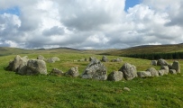

<< Text Pages >> 역삼동 - Burial Chamber or Dolmen in South Korea
Submitted by Klingon on Tuesday, 14 November 2006 Page Views: 3120
Neolithic and Bronze AgeSite Name: 역삼동 Alternative Name: yeok-ssam-dongCountry: South Korea
NOTE: This site is 12.714 km away from the location you searched for.
Type: Burial Chamber or Dolmen
Latitude: 37.754660N Longitude: 126.933210E
Condition:
| 5 | Perfect |
| 4 | Almost Perfect |
| 3 | Reasonable but with some damage |
| 2 | Ruined but still recognisable as an ancient site |
| 1 | Pretty much destroyed, possibly visible as crop marks |
| 0 | No data. |
| -1 | Completely destroyed |
| 5 | Superb |
| 4 | Good |
| 3 | Ordinary |
| 2 | Not Good |
| 1 | Awful |
| 0 | No data. |
| 5 | Can be driven to, probably with disabled access |
| 4 | Short walk on a footpath |
| 3 | Requiring a bit more of a walk |
| 2 | A long walk |
| 1 | In the middle of nowhere, a nightmare to find |
| 0 | No data. |
| 5 | co-ordinates taken by GPS or official recorded co-ordinates |
| 4 | co-ordinates scaled from a detailed map |
| 3 | co-ordinates scaled from a bad map |
| 2 | co-ordinates of the nearest village |
| 1 | co-ordinates of the nearest town |
| 0 | no data |
Be the first person to rate this site - see the 'Contribute!' box in the right hand menu.
Internal Links:
External Links:
Burial Chamber (Dolmen) in South Korea
SM Nelson (1993) Archaeology of Korea. Cambridge World Archaeology. Cambridge. pp. 112
You may be viewing yesterday's version of this page. To see the most up to date information please register for a free account.
Do not use the above information on other web sites or publications without permission of the contributor.
Nearby Images from Flickr
The above images may not be of the site on this page, but were taken nearby. They are loaded from Flickr so please click on them for image credits.
Click here to see more info for this site
Nearby sites
Click here to view sites on an interactive map of the areaKey: Red: member's photo, Blue: 3rd party photo, Yellow: other image, Green: no photo - please go there and take one, Grey: site destroyed
Download sites to:
KML (Google Earth)
GPX (GPS waypoints)
CSV (Garmin/Navman)
CSV (Excel)
To unlock full downloads you need to sign up as a Contributory Member. Otherwise downloads are limited to 50 sites.
Turn off the page maps and other distractions
Nearby sites listing. In the following links * = Image available
18.2km ESE 109° 가락동 Burial Chamber or Dolmen
26.0km S 171° National Museum of Korea* Museum
26.8km SE 146° AchasanSeong* Hillfort
27.6km SE 141° Seoul Amsa-dong prehistoric Sites* Ancient Village or Settlement
29.2km SE 145° BungnapToseong* Hillfort
31.1km SSE 148° MongchonToseong* Hillfort
31.7km SSE 152° Seokchon-dong gobungun* Chambered Cairn
31.9km SSE 149° Bangi-dong gobungun* Round Barrow(s)
31.9km W 260° GoJeong-ri dolmens* Burial Chamber or Dolmen
35.8km SSE 158° 수송리 Burial Chamber or Dolmen
37.6km SE 144° NamhanSanseong* Hillfort
37.8km S 190° Gahakdong dolmens* Burial Chamber or Dolmen
39.3km W 272° Daesan-ni goindol* Burial Chamber or Dolmen
42.1km N 358° Haggog-ri Dolmen* Burial Chamber or Dolmen
43.1km W 273° Bugeun-ni goindolgun* Burial Chamber or Dolmen
43.6km W 273° Gang-hwa goindolgun* Burial Chamber or Dolmen
44.6km W 268° Gocheon-ni goindolgun* Burial Chamber or Dolmen
44.7km W 272° Bugeun-ni Jeomgol goindol* Burial Chamber or Dolmen
44.9km N 8° 옥성리 Burial Chamber or Dolmen
45.0km W 270° Samgeo-ri goindolgun* Burial Chamber or Dolmen
46.0km W 271° Sinsam-ni goindol* Burial Chamber or Dolmen
46.0km SSE 157° 양구리 Burial Chamber or Dolmen
46.8km W 267° Osang-ri Dolmens* Burial Chamber or Dolmen
47.4km W 275° Gyosan-ni goindolgun* Burial Chamber or Dolmen
48.2km SE 137° 상자포리 Burial Chamber or Dolmen
View more nearby sites and additional images


 We would like to know more about this location. Please feel free to add a brief description and any relevant information in your own language.
 Wir möchten mehr über diese Stätte erfahren. Bitte zögern Sie nicht, eine kurze Beschreibung und relevante Informationen in Deutsch hinzuzufügen.
 Nous aimerions en savoir encore un peu sur les lieux. S'il vous plaît n'hesitez pas à ajouter une courte description et tous les renseignements pertinents dans votre propre langue.
 Quisieramos informarnos un poco más de las lugares. No dude en añadir una breve descripción y otros datos relevantes en su propio idioma.