

<< Our Photo Pages >> Obiiwa - Natural Stone / Erratic / Other Natural Feature in Japan in Kyūshū
Submitted by Aska on Monday, 13 January 2014 Page Views: 1979
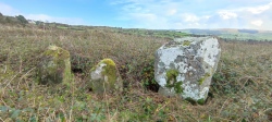
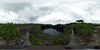
Natural PlacesSite Name: Obiiwa Alternative Name: 帯岩, 下地島巨石Country: Japan
NOTE: This site is 16.932 km away from the location you searched for.
Region: Kyūshū Type: Natural Stone / Erratic / Other Natural Feature
Nearest Town: Miyako-jima (Okinawa pref.) Nearest Village: Shimoji-jima 下地島
Latitude: 24.819070N Longitude: 125.140780E
Condition:
| 5 | Perfect |
| 4 | Almost Perfect |
| 3 | Reasonable but with some damage |
| 2 | Ruined but still recognisable as an ancient site |
| 1 | Pretty much destroyed, possibly visible as crop marks |
| 0 | No data. |
| -1 | Completely destroyed |
| 5 | Superb |
| 4 | Good |
| 3 | Ordinary |
| 2 | Not Good |
| 1 | Awful |
| 0 | No data. |
| 5 | Can be driven to, probably with disabled access |
| 4 | Short walk on a footpath |
| 3 | Requiring a bit more of a walk |
| 2 | A long walk |
| 1 | In the middle of nowhere, a nightmare to find |
| 0 | No data. |
| 5 | co-ordinates taken by GPS or official recorded co-ordinates |
| 4 | co-ordinates scaled from a detailed map |
| 3 | co-ordinates scaled from a bad map |
| 2 | co-ordinates of the nearest village |
| 1 | co-ordinates of the nearest town |
| 0 | no data |
Internal Links:
External Links:
")
A huge rock (12.5m high, 59.9m circumstance) on the western shore of Shimoji-jima island close to Shimoji Airport which is only used for the takeoff & landing training of the pilot trainees. This is believed as the only one survivor of the numerous rocks which were drifted up from the sea by the tsumani in 1771, other Tunami stones were blasted during the construction of the airport. "Obi-iwa" means 'banded rock', named after the central ditch eroded by the tides when it was submerged in the sea.
You may be viewing yesterday's version of this page. To see the most up to date information please register for a free account.
Do not use the above information on other web sites or publications without permission of the contributor.
Nearby Images from Flickr


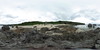
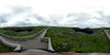
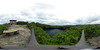
The above images may not be of the site on this page, but were taken nearby. They are loaded from Flickr so please click on them for image credits.
Click here to see more info for this site
Nearby sites
Click here to view sites on an interactive map of the areaKey: Red: member's photo, Blue: 3rd party photo, Yellow: other image, Green: no photo - please go there and take one, Grey: site destroyed
Download sites to:
KML (Google Earth)
GPX (GPS waypoints)
CSV (Garmin/Navman)
CSV (Excel)
To unlock full downloads you need to sign up as a Contributory Member. Otherwise downloads are limited to 50 sites.
Turn off the page maps and other distractions
Nearby sites listing. In the following links * = Image available
2.2km NE 43° Sawada-no Hama shore* Natural Stone / Erratic / Other Natural Feature
4.2km E 94° Susabi Myāka* Cist
5.0km E 100° Nāzaku Myāka* Cist
5.0km E 95° Tamaishi (in Irabu-jima island)* Standing Stone (Menhir)
13.1km ESE 106° Hisamatsu Myāka* Cist
13.7km E 97° Nishi Tsuga-baka* Chambered Tomb
13.8km E 96° Upudati-Uputunu Myāka* Cist
13.9km E 98° Tomb of Shimoji Family* Chambered Tomb
14.1km E 95° Tomb of Nakasone Tuyumyā* Chambered Tomb
14.2km E 95° Shōun-ji temple* Modern Stone Circle etc
14.2km E 93° Jintōzeiseki* Standing Stone (Menhir)
14.4km E 95° Nakaya Kanimori Myāka* Cist
15.2km ESE 122° Yonaha dolmen* Cist
15.3km SE 133° Kurima Tōmi* Broch or Nuraghe
15.4km SE 135° Sumuryā Myāka* Cist
16.0km ENE 67° Tomb of Yusuma-no-shū* Chambered Tomb
16.3km ENE 58° Karimata Tōmi* Sculptured Stone
16.4km ESE 121° Kawamitsu Uputunu Myāka* Cist
16.5km ESE 106° Nanabari-no Tamaishi* Standing Stone (Menhir)
17.0km ENE 68° Shimajiri Tōmi* Sculptured Stone
17.2km ESE 120° Myātsu-haka* Cist
17.6km ESE 106° Ishiniwa* Modern Stone Circle etc
19.4km ESE 108° Nobarudake-no Tamaishi* Standing Stone (Menhir)
21.1km ESE 112° PinzaAbu cave* Cave or Rock Shelter
23.7km ESE 116° Uruka Tōmi* Broch or Nuraghe
View more nearby sites and additional images


 We would like to know more about this location. Please feel free to add a brief description and any relevant information in your own language.
 Wir möchten mehr über diese Stätte erfahren. Bitte zögern Sie nicht, eine kurze Beschreibung und relevante Informationen in Deutsch hinzuzufügen.
 Nous aimerions en savoir encore un peu sur les lieux. S'il vous plaît n'hesitez pas à ajouter une courte description et tous les renseignements pertinents dans votre propre langue.
 Quisieramos informarnos un poco más de las lugares. No dude en añadir una breve descripción y otros datos relevantes en su propio idioma.