


<< Our Photo Pages >> Mulka's Cave - Rock Art in Australia
Submitted by theCaptain on Friday, 02 February 2024 Page Views: 2473
Rock ArtSite Name: Mulka's CaveCountry: Australia Type: Rock Art
Nearest Town: Hyden
Latitude: 32.315422S Longitude: 118.961843E
Condition:
| 5 | Perfect |
| 4 | Almost Perfect |
| 3 | Reasonable but with some damage |
| 2 | Ruined but still recognisable as an ancient site |
| 1 | Pretty much destroyed, possibly visible as crop marks |
| 0 | No data. |
| -1 | Completely destroyed |
| 5 | Superb |
| 4 | Good |
| 3 | Ordinary |
| 2 | Not Good |
| 1 | Awful |
| 0 | No data. |
| 5 | Can be driven to, probably with disabled access |
| 4 | Short walk on a footpath |
| 3 | Requiring a bit more of a walk |
| 2 | A long walk |
| 1 | In the middle of nowhere, a nightmare to find |
| 0 | No data. |
| 5 | co-ordinates taken by GPS or official recorded co-ordinates |
| 4 | co-ordinates scaled from a detailed map |
| 3 | co-ordinates scaled from a bad map |
| 2 | co-ordinates of the nearest village |
| 1 | co-ordinates of the nearest town |
| 0 | no data |
Internal Links:
External Links:
I have visited· I would like to visit
Pawl.Seimon visited on 1st Apr 2003 - their rating: Cond: 4 Amb: 4 Access: 4
")
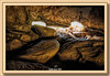
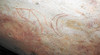
At first there doesn't appear to be much to see, but once your eyes grow accustomed to the low light, images become clearer. There are hand stencils, plus depictions of the animals used as food in this area. Some are hard to spot and may require some manouvering up the sloping floor in order to better see out-of-the-way parts of the ceiling. The harder you look for the markings, the more you see.
The art in Mulka's Cave is believed to be around 3000 years old according to a WA museum report I read. On the other hand, another internet source claimed 30000 years, and the Aborigines would have been around back then. In any case, the cave paintings are very old.
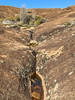
There are also some pleasant walks from the car park, which complement the cave and make a visit even more worthwhile. My legs definitely appreciated a walk after a long drive.
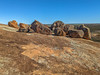
A short loop trail passes through a range of local vegetation, and reveals fine examples of a gnamma hole and a lizard trap used by Aboriginals in millenia past. The gnamma hole is a rock waterhole which retains water long after rain, and the lizard trap in this case is simply a slab of granite propped up on stones. They may be basic, but features like these helped the Aboriginals thrive, and there are information signs to fill you in on the details.
Source and more information: a href="roamingdownunder<8>">www.roamingdownunder.com/mulkas-cave.php">roamingdownunder<8>
You may be viewing yesterday's version of this page. To see the most up to date information please register for a free account.
Do not use the above information on other web sites or publications without permission of the contributor.
Nearby Images from Flickr

The above images may not be of the site on this page, but were taken nearby. They are loaded from Flickr so please click on them for image credits.
Click here to see more info for this site
Nearby sites
Click here to view sites on an interactive map of the areaKey: Red: member's photo, Blue: 3rd party photo, Yellow: other image, Green: no photo - please go there and take one, Grey: site destroyed
Download sites to:
KML (Google Earth)
GPX (GPS waypoints)
CSV (Garmin/Navman)
CSV (Excel)
To unlock full downloads you need to sign up as a Contributory Member. Otherwise downloads are limited to 50 sites.
Turn off the page maps and other distractions
Nearby sites listing. In the following links * = Image available
15.5km SSW 203° Wave Rock* Natural Stone / Erratic / Other Natural Feature
294.8km W 277° Western Australia Museum* Museum
329.5km ESE 121° Esperance Stonehenge* Modern Stone Circle etc
407.8km WNW 297° The Pinnacles* Natural Stone / Erratic / Other Natural Feature
414.2km WSW 241° Mammoth Cave Margaret River* Cave or Rock Shelter
1036.1km E 87° Koonalda Cave Cave or Rock Shelter
1039.9km N 1° Hope Downs Cave or Rock Shelter
1076.1km N 354° Pibara Petroglyphs* Rock Art
1217.0km N 355° Nunyerry Creek* Rock Art
1318.2km N 350° Burrup Peninsula* Rock Art
1407.0km ENE 60° Ayers Rock* Rock Art
1630.2km ENE 62° Henbury Meteorite Craters* Natural Stone / Erratic / Other Natural Feature
1706.5km NNE 33° Wolf Creek Crater Natural Stone / Erratic / Other Natural Feature
1840.5km E 91° Warratyi* Cave or Rock Shelter
1866.8km E 92° Nala Stone Men* Modern Stone Circle etc
2002.5km NE 53° Devil's Marbles* Natural Stone / Erratic / Other Natural Feature
2064.9km NNE 24° Drysdale River National Park Rock Art
2072.5km ESE 113° Mount Gambier* Ancient Mine, Quarry or other Industry
2153.5km NNE 23° Kalumburu Cave or Rock Shelter
2249.4km E 101° Mungo, Australia* Ancient Village or Settlement
2388.0km ESE 113° Geelong Stone Setting Standing Stones
2393.3km ESE 112° Wurdi Youang* Stone Row / Alignment
2496.5km E 94° 25-3-0057 Stone Row / Alignment
2519.8km N 4° Rindi Umalulu Burial Chamber or Dolmen
2521.8km N 1° Waikabubak East Burial Chamber or Dolmen
View more nearby sites and additional images


 We would like to know more about this location. Please feel free to add a brief description and any relevant information in your own language.
 Wir möchten mehr über diese Stätte erfahren. Bitte zögern Sie nicht, eine kurze Beschreibung und relevante Informationen in Deutsch hinzuzufügen.
 Nous aimerions en savoir encore un peu sur les lieux. S'il vous plaît n'hesitez pas à ajouter une courte description et tous les renseignements pertinents dans votre propre langue.
 Quisieramos informarnos un poco más de las lugares. No dude en añadir una breve descripción y otros datos relevantes en su propio idioma.