

<< Text Pages >> Dongshan - Ancient Village or Settlement in China
Submitted by DrewParsons on Sunday, 23 May 2010 Page Views: 5339
Multi-periodSite Name: DongshanCountry: China
NOTE: This site is 75.068 km away from the location you searched for.
Type: Ancient Village or Settlement
Nearest Town: Yixing Nearest Village: Dongshan
Latitude: 31.341000N Longitude: 119.833000E
Condition:
| 5 | Perfect |
| 4 | Almost Perfect |
| 3 | Reasonable but with some damage |
| 2 | Ruined but still recognisable as an ancient site |
| 1 | Pretty much destroyed, possibly visible as crop marks |
| 0 | No data. |
| -1 | Completely destroyed |
| 5 | Superb |
| 4 | Good |
| 3 | Ordinary |
| 2 | Not Good |
| 1 | Awful |
| 0 | No data. |
| 5 | Can be driven to, probably with disabled access |
| 4 | Short walk on a footpath |
| 3 | Requiring a bit more of a walk |
| 2 | A long walk |
| 1 | In the middle of nowhere, a nightmare to find |
| 0 | No data. |
| 5 | co-ordinates taken by GPS or official recorded co-ordinates |
| 4 | co-ordinates scaled from a detailed map |
| 3 | co-ordinates scaled from a bad map |
| 2 | co-ordinates of the nearest village |
| 1 | co-ordinates of the nearest town |
| 0 | no data |
Internal Links:
External Links:
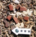
Neolithic ruins at Dongshan Village near Lake Tai Hu in eastern Jiangsu province
The Neolithic ruins at Dongshan Village near Lake Tai Hu in eastern Jiangsu province provide evidence of one of the earliest Chinese civilizations ever found. Covering more than 2,000 square meters the site is divided into two parts: the eastern area where eight tombs have been found with over 200 pieces of jade, stone vessels and pottery, and the western part where a number of small tombs and house ruins have been discovered. All the tombs are strictly organized into social levels providing the earliest yet proof of China's ancient hierarchy system during the era of the little known Songze culture.
Resourced by coldrum from a news item. More at: http://english.cctv.com/program/newshour/20100116/102226.shtml
You may be viewing yesterday's version of this page. To see the most up to date information please register for a free account.
Do not use the above information on other web sites or publications without permission of the contributor.
Nearby Images from Flickr


The above images may not be of the site on this page, but were taken nearby. They are loaded from Flickr so please click on them for image credits.
Click here to see more info for this site
Nearby sites
Click here to view sites on an interactive map of the areaKey: Red: member's photo, Blue: 3rd party photo, Yellow: other image, Green: no photo - please go there and take one, Grey: site destroyed
Download sites to:
KML (Google Earth)
GPX (GPS waypoints)
CSV (Garmin/Navman)
CSV (Excel)
To unlock full downloads you need to sign up as a Contributory Member. Otherwise downloads are limited to 50 sites.
Turn off the page maps and other distractions
Nearby sites listing. In the following links * = Image available
112.9km NW 316° Yangshan Mountain Steles Ancient Mine, Quarry or other Industry
156.1km E 94° Shanghai Museum* Museum
170.1km SSE 163° Yunnan Neolithic age site Ancient Village or Settlement
367.7km N 350° General's Cliff* Rock Art
420.7km WSW 243° Xianrendong Cave Cave or Rock Shelter
528.1km SW 229° Fujiacun Ancient Village or Settlement
625.0km NNW 347° Linzi* Ancient Village or Settlement
630.0km NNW 333° Great Wall of Qi* Misc. Earthwork
655.1km NNW 345° Chenzhuang Ruins Ancient Village or Settlement
682.5km ENE 68° 법천리 Burial Chamber or Dolmen
696.1km ENE 59° Gin Do Sundol* Standing Stone (Menhir)
706.5km SSE 166° Yangmingshan Pyramid Pyramid / Mastaba
728.6km NE 51° YoungKwang County Dolmen* Burial Chamber or Dolmen
732.1km NE 51° Backsoo(su) dolmen* Burial Chamber or Dolmen
732.1km ENE 58° 장전리 Burial Chamber or Dolmen
733.7km NW 318° Ancient City of Anyang Ancient Village or Settlement
738.8km ENE 59° 영암 Burial Chamber or Dolmen
753.6km ENE 59° 양평리 Burial Chamber or Dolmen
754.7km ENE 59° BangChon-ri Dolmen* Burial Chamber or Dolmen
758.7km ENE 57° 우산리 Burial Chamber or Dolmen
762.9km WNW 301° Erlitou Ancient Village or Settlement
764.4km NE 53° Gochang County Menhir* Standing Stone (Menhir)
765.1km NE 53° Big Big Cup Mark* Rock Art
765.5km NE 53° 7-193 Dolmen* Burial Chamber or Dolmen
767.0km NE 56° 구봉리 Burial Chamber or Dolmen
View more nearby sites and additional images


 We would like to know more about this location. Please feel free to add a brief description and any relevant information in your own language.
 Wir möchten mehr über diese Stätte erfahren. Bitte zögern Sie nicht, eine kurze Beschreibung und relevante Informationen in Deutsch hinzuzufügen.
 Nous aimerions en savoir encore un peu sur les lieux. S'il vous plaît n'hesitez pas à ajouter une courte description et tous les renseignements pertinents dans votre propre langue.
 Quisieramos informarnos un poco más de las lugares. No dude en añadir una breve descripción y otros datos relevantes en su propio idioma.