

<< Our Photo Pages >> Schälchenstein Ankershagen - Rock Art in Germany in Mecklenburg-Western Pomerania
Submitted by macze84 on Sunday, 24 November 2019 Page Views: 534
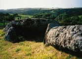
Rock ArtSite Name: Schälchenstein AnkershagenCountry: Germany
NOTE: This site is 2.32 km away from the location you searched for.
Land: Mecklenburg-Western Pomerania Type: Rock Art
Nearest Town: Penzlin Nearest Village: Ankershagen
Latitude: 53.484142N Longitude: 12.957310E
Condition:
| 5 | Perfect |
| 4 | Almost Perfect |
| 3 | Reasonable but with some damage |
| 2 | Ruined but still recognisable as an ancient site |
| 1 | Pretty much destroyed, possibly visible as crop marks |
| 0 | No data. |
| -1 | Completely destroyed |
| 5 | Superb |
| 4 | Good |
| 3 | Ordinary |
| 2 | Not Good |
| 1 | Awful |
| 0 | No data. |
| 5 | Can be driven to, probably with disabled access |
| 4 | Short walk on a footpath |
| 3 | Requiring a bit more of a walk |
| 2 | A long walk |
| 1 | In the middle of nowhere, a nightmare to find |
| 0 | No data. |
| 5 | co-ordinates taken by GPS or official recorded co-ordinates |
| 4 | co-ordinates scaled from a detailed map |
| 3 | co-ordinates scaled from a bad map |
| 2 | co-ordinates of the nearest village |
| 1 | co-ordinates of the nearest town |
| 0 | no data |
Internal Links:
External Links:
")
Stone with several cup marks located next to the Heinrich Schliemann Museum in Ankershagen.
You may be viewing yesterday's version of this page. To see the most up to date information please register for a free account.
")
Do not use the above information on other web sites or publications without permission of the contributor.
Nearby Images from Flickr

The above images may not be of the site on this page, but were taken nearby. They are loaded from Flickr so please click on them for image credits.
Click here to see more info for this site
Nearby sites
Click here to view sites on an interactive map of the areaKey: Red: member's photo, Blue: 3rd party photo, Yellow: other image, Green: no photo - please go there and take one, Grey: site destroyed
Download sites to:
KML (Google Earth)
GPX (GPS waypoints)
CSV (Garmin/Navman)
CSV (Excel)
To unlock full downloads you need to sign up as a Contributory Member. Otherwise downloads are limited to 50 sites.
Turn off the page maps and other distractions
Nearby sites listing. In the following links * = Image available
53m ESE 122° Schliemann Museum* Museum
3.0km W 272° Freidorf Hügelgräber* Barrow Cemetery
3.0km W 274° Freidorf Steingrab 2* Chambered Tomb
3.0km W 268° Freidorf Steingrab 1* Chambered Tomb
3.0km W 268° Schalenstein Freidorf* Rock Art
3.3km W 279° Freidorf Steingrab 3* Chambered Tomb
4.5km ENE 67° Mollenstorf Rillenstein* Rock Art
4.7km NNW 341° Steingrab Möllenhagen* Chambered Tomb
4.8km NNW 336° Burgwall Möllenhagen* Ancient Village or Settlement
5.2km ENE 77° Hügelgräber Mollenstorf* Barrow Cemetery
5.4km WNW 298° Klein Dratow Steingrab* Burial Chamber or Dolmen
6.3km WNW 295° Grosssteingrab Klein Dratow II Chambered Tomb
8.4km N 359° Grosssteingrab Gross Flotow* Burial Chamber or Dolmen
8.6km N 353° Riesenstein Flotow* Natural Stone / Erratic / Other Natural Feature
9.8km W 281° Kargow Steingrab Chambered Tomb
11.8km ENE 76° Tempelberg Krukow* Stone Circle
12.1km E 89° Hügelgrab Siehdichum Round Barrow(s)
12.6km ENE 59° Slawendorf Passentin* Museum
12.6km E 98° Schalenstein Zippelow 2 Rock Art
12.6km E 99° Schalenstein Zippelow 1 Rock Art
12.7km E 94° Wustrow Hügelgrab* Round Barrow(s)
12.8km E 85° Hügelgrab Alt Rehse* Round Barrow(s)
13.5km ESE 103° Bacherswall Ancient Village or Settlement
13.7km E 92° Fischerinsel Wustrow Ancient Village or Settlement
15.0km SSE 156° Summstein Weiße Brücke Modern Stone Circle etc
View more nearby sites and additional images


 We would like to know more about this location. Please feel free to add a brief description and any relevant information in your own language.
 Wir möchten mehr über diese Stätte erfahren. Bitte zögern Sie nicht, eine kurze Beschreibung und relevante Informationen in Deutsch hinzuzufügen.
 Nous aimerions en savoir encore un peu sur les lieux. S'il vous plaît n'hesitez pas à ajouter une courte description et tous les renseignements pertinents dans votre propre langue.
 Quisieramos informarnos un poco más de las lugares. No dude en añadir una breve descripción y otros datos relevantes en su propio idioma.