 with our Megalithic Portal iPhone app")


<< Our Photo Pages >> Ole Rømers Høj - Round Barrow(s) in Denmark in Hovedstaden
Submitted by holger_rix on Saturday, 05 December 2015 Page Views: 1304
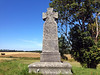
Neolithic and Bronze AgeSite Name: Ole Rømers HøjCountry: Denmark County: Hovedstaden Type: Round Barrow(s)
Latitude: 55.684690N Longitude: 12.301990E
Condition:
| 5 | Perfect |
| 4 | Almost Perfect |
| 3 | Reasonable but with some damage |
| 2 | Ruined but still recognisable as an ancient site |
| 1 | Pretty much destroyed, possibly visible as crop marks |
| 0 | No data. |
| -1 | Completely destroyed |
| 5 | Superb |
| 4 | Good |
| 3 | Ordinary |
| 2 | Not Good |
| 1 | Awful |
| 0 | No data. |
| 5 | Can be driven to, probably with disabled access |
| 4 | Short walk on a footpath |
| 3 | Requiring a bit more of a walk |
| 2 | A long walk |
| 1 | In the middle of nowhere, a nightmare to find |
| 0 | No data. |
| 5 | co-ordinates taken by GPS or official recorded co-ordinates |
| 4 | co-ordinates scaled from a detailed map |
| 3 | co-ordinates scaled from a bad map |
| 2 | co-ordinates of the nearest village |
| 1 | co-ordinates of the nearest town |
| 0 | no data |
Be the first person to rate this site - see the 'Contribute!' box in the right hand menu.
Internal Links:
External Links:
")
You may be viewing yesterday's version of this page. To see the most up to date information please register for a free account.
")
")
")
Do not use the above information on other web sites or publications without permission of the contributor.
Nearby Images from Flickr

The above images may not be of the site on this page, but were taken nearby. They are loaded from Flickr so please click on them for image credits.
Click here to see more info for this site
Nearby sites
Click here to view sites on an interactive map of the areaKey: Red: member's photo, Blue: 3rd party photo, Yellow: other image, Green: no photo - please go there and take one, Grey: site destroyed
Download sites to:
KML (Google Earth)
GPX (GPS waypoints)
CSV (Garmin/Navman)
CSV (Excel)
To unlock full downloads you need to sign up as a Contributory Member. Otherwise downloads are limited to 50 sites.
Turn off the page maps and other distractions
Nearby sites listing. In the following links * = Image available
4.6km NW 325° Edelgave Gyngehøj* Round Barrow(s)
5.0km WNW 294° Herringlose Sømhøj* Round Barrow(s)
5.5km N 352° Smørumovre Bautasten* Standing Stones
6.1km NNW 346° Smørumovre Jættestue* Passage Grave
6.2km W 281° Hvedstrup Stenkiste* Cist
6.3km NW 320° Hove Buehøj* Round Barrow(s)
6.4km NW 321° Hove Langdysse* Long Barrow
6.6km NNW 343° Maglehøj ved Smørumovre* Round Barrow(s)
7.0km N 354° Kong Svends Høj 2* Round Barrow(s)
7.1km WSW 237° Kallerupstenen* Carving
7.1km WNW 286° Hvedstrup Langdysse 2* Long Barrow
7.1km WNW 286° Hvedstrup Langdysse 1* Long Barrow
7.2km W 278° Ågerup Hvedshøj* Round Barrow(s)
7.4km WNW 283° Ågerup Nissedysse* Long Barrow
7.5km WSW 238° Hedehusene Station Rundhøj* Round Barrow(s)
7.5km W 281° Ågerup Langdysse (Hovedstaden)* Long Barrow
7.6km N 1° Hyldhøj (Måløv)* Round Barrow(s)
7.7km W 277° Ågerup Thorsbjerghøj* Round Barrow(s)
7.7km WNW 287° Gundsølille Langdysse 2* Long Barrow
7.7km W 275° Ågerup Langagerdysse* Long Barrow
7.9km WNW 291° Gundsølille Langdysse 1* Long Barrow
8.0km W 274° Ågerup Bukketornehøj* Round Barrow(s)
8.0km N 3° Jungshøj (Måløv)* Round Barrow(s)
8.1km W 279° Hødyssen Langdysse* Long Barrow
8.1km N 5° Gjærshøj (Måløv)* Round Barrow(s)
View more nearby sites and additional images


 We would like to know more about this location. Please feel free to add a brief description and any relevant information in your own language.
 Wir möchten mehr über diese Stätte erfahren. Bitte zögern Sie nicht, eine kurze Beschreibung und relevante Informationen in Deutsch hinzuzufügen.
 Nous aimerions en savoir encore un peu sur les lieux. S'il vous plaît n'hesitez pas à ajouter une courte description et tous les renseignements pertinents dans votre propre langue.
 Quisieramos informarnos un poco más de las lugares. No dude en añadir una breve descripción y otros datos relevantes en su propio idioma.