


<< Text Pages >> Barbarano Romano Etruscan Necropolis - Chambered Tomb in Italy in Lazio/Roma
Submitted by llappin on Thursday, 26 May 2005 Page Views: 11016
Neolithic and Bronze AgeSite Name: Barbarano Romano Etruscan Necropolis Alternative Name: Park of MarturanumCountry: Italy Region: Lazio/Roma Type: Chambered Tomb
Nearest Town: Viterbo Nearest Village: Barbarano Romano
Latitude: 42.263318N Longitude: 12.082866E
Condition:
| 5 | Perfect |
| 4 | Almost Perfect |
| 3 | Reasonable but with some damage |
| 2 | Ruined but still recognisable as an ancient site |
| 1 | Pretty much destroyed, possibly visible as crop marks |
| 0 | No data. |
| -1 | Completely destroyed |
| 5 | Superb |
| 4 | Good |
| 3 | Ordinary |
| 2 | Not Good |
| 1 | Awful |
| 0 | No data. |
| 5 | Can be driven to, probably with disabled access |
| 4 | Short walk on a footpath |
| 3 | Requiring a bit more of a walk |
| 2 | A long walk |
| 1 | In the middle of nowhere, a nightmare to find |
| 0 | No data. |
| 5 | co-ordinates taken by GPS or official recorded co-ordinates |
| 4 | co-ordinates scaled from a detailed map |
| 3 | co-ordinates scaled from a bad map |
| 2 | co-ordinates of the nearest village |
| 1 | co-ordinates of the nearest town |
| 0 | no data |
Internal Links:
External Links:
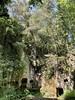
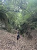
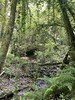
Located in one of Italy's extraordinary Etruscan necropolises, in a wild setting of chestnut woods, thick ferns, and scrub oaks, the tombs of Barbarano Romano provide the setting for Lappin's novel, The Etruscans.
They are easily accessed. There are no fences, but you need wellingtons to ford a narrow stream. The tombs are found in an area known as the Park of Marturanum which also includes a ruined medieval church and cloister, as well as a Roman bath. Approximately 90 minutes from Rome. In the nearby village of Barbarano Romano, there is a small but well-furnished Etruscan museum.
More information at Etruscan Corner website.
You may be viewing yesterday's version of this page. To see the most up to date information please register for a free account.
Do not use the above information on other web sites or publications without permission of the contributor.
Nearby Images from Flickr
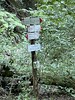
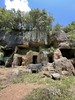
The above images may not be of the site on this page, but were taken nearby. They are loaded from Flickr so please click on them for image credits.
Click here to see more info for this site
Nearby sites
Click here to view sites on an interactive map of the areaKey: Red: member's photo, Blue: 3rd party photo, Yellow: other image, Green: no photo - please go there and take one, Grey: site destroyed
Download sites to:
KML (Google Earth)
GPX (GPS waypoints)
CSV (Garmin/Navman)
CSV (Excel)
To unlock full downloads you need to sign up as a Contributory Member. Otherwise downloads are limited to 50 sites.
Turn off the page maps and other distractions
Nearby sites listing. In the following links * = Image available
6.3km WNW 293° Pian di Vescovo Rock Cut Tomb
7.1km SW 231° Civitella Cesi Etruscan Tomb* Rock Cut Tomb
7.9km WSW 238° Casale Vignale Necropolis Chambered Cairn
12.3km ESE 103° Sutri Necropolis* Rock Cut Tomb
12.3km ESE 103° Sutri amphitheatre* Ancient Village or Settlement
14.0km NW 306° Norchia Etruscan Necropolis* Rock Cut Tomb
18.9km NNE 31° Mount Cimino Votive Site* Ancient Temple
23.2km W 269° Tarquinia* Ancient Village or Settlement
28.3km NNE 31° Bomarzo Etruscan 'Pyramid' Altar* Ancient Temple
28.6km S 177° Cerveteri Necropoli della Banditaceia* Rock Cut Tomb
30.4km WNW 302° San Giulano Rock Cut tombs Rock Cut Tomb
50.2km SE 142° Gregorian Etruscan Museum* Museum
50.9km SE 140° Heliopolis Seti I Piazza del Popolo Obelisk* Standing Stone (Menhir)
50.9km N 2° Necropoli del Crocifisso del Tufo Rock Cut Tomb
52.1km SE 141° Sais - Piazza Minerva Obelisk* Standing Stone (Menhir)
52.5km SE 141° Lupercale Shrine* Cave or Rock Shelter
52.8km SE 139° Heliopolis Ramesses II Termini Obelisk* Standing Stone (Menhir)
52.9km SE 141° Rome.* Ancient Village or Settlement
53.9km NNW 330° Vitozza* Cave or Rock Shelter
54.5km SE 140° Karnak Temple of Amun Lateran Obelisk* Standing Stone (Menhir)
56.3km NW 321° Sovana Necropolis* Rock Cut Tomb
56.7km NW 320° Tomba della Sirena* Rock Cut Tomb
56.9km NW 320° Via cava di S. Sebastiano* Ancient Trackway
57.2km NE 43° Carsulae Ancient Village or Settlement
57.4km NW 320° Ildebranda Tomb* Rock Cut Tomb
View more nearby sites and additional images


 We would like to know more about this location. Please feel free to add a brief description and any relevant information in your own language.
 Wir möchten mehr über diese Stätte erfahren. Bitte zögern Sie nicht, eine kurze Beschreibung und relevante Informationen in Deutsch hinzuzufügen.
 Nous aimerions en savoir encore un peu sur les lieux. S'il vous plaît n'hesitez pas à ajouter une courte description et tous les renseignements pertinents dans votre propre langue.
 Quisieramos informarnos un poco más de las lugares. No dude en añadir una breve descripción y otros datos relevantes en su propio idioma.