

<< Text Pages >> Hope Downs - Cave or Rock Shelter in Australia
Submitted by Andy B on Tuesday, 15 April 2008 Page Views: 7624
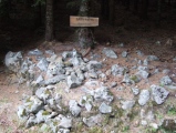
Natural PlacesSite Name: Hope Downs Alternative Name: DjadjilingCountry: Australia
NOTE: This site is 387.003 km away from the location you searched for.
Type: Cave or Rock Shelter
Latitude: 22.964565S Longitude: 119.128914E
Condition:
| 5 | Perfect |
| 4 | Almost Perfect |
| 3 | Reasonable but with some damage |
| 2 | Ruined but still recognisable as an ancient site |
| 1 | Pretty much destroyed, possibly visible as crop marks |
| 0 | No data. |
| -1 | Completely destroyed |
| 5 | Superb |
| 4 | Good |
| 3 | Ordinary |
| 2 | Not Good |
| 1 | Awful |
| 0 | No data. |
| 5 | Can be driven to, probably with disabled access |
| 4 | Short walk on a footpath |
| 3 | Requiring a bit more of a walk |
| 2 | A long walk |
| 1 | In the middle of nowhere, a nightmare to find |
| 0 | No data. |
| 5 | co-ordinates taken by GPS or official recorded co-ordinates |
| 4 | co-ordinates scaled from a detailed map |
| 3 | co-ordinates scaled from a bad map |
| 2 | co-ordinates of the nearest village |
| 1 | co-ordinates of the nearest town |
| 0 | no data |
Be the first person to rate this site - see the 'Contribute!' box in the right hand menu.
Internal Links:
External Links:
Rock Shelter and stone tools find in Australia. Aboriginal site among Australia's oldest. Aboriginal tools found in Western Australia and dating back 35,000 years are surprisingly sophisticated and varied, archaeologists say. They believe the site may yet reveal artefacts up to 45,000 years old, making it older than the internationally famous Mungo Man site found in New South Wales. Achaeologists hired by one of the traditional owners in the Pilbara region, the Martidja Banyjima people, uncovered the ancient tools at a rock overhang on the site of the A$1 billion Hope Downs iron ore mine.
The site, which is about 300 kilometres south of Port Hedland, has been named Djadjiling by the Banyjima people. This honours their ancestral Dreaming track of the same name, which tells the story of how the earth was formed and the cycles of life and nature in the area were created.
Consultant archaeologist Dr Neale Draper says the site is the earliest dated archaeological site in the Pilbara region, which until now only had 20,000 years of documented Aboriginal occupation.
"The site is potentially amongst the oldest investigated in Australia, and further radiocarbon determinations will undoubtedly resolve this issue," says Draper, managing director of Australian Cultural Heritage Management.
Draper says charcoal samples from the site were sent to the University of Waikato, in New Zealand, and radiocarbon dated to 35,000 years old. But he says there is about another 12 centimetres of sediment yet to be revealed.
"Considering about 10 centimetres of sediment separates the 25,000 and 35,000-year mark there could be material dating back another 10,000 years," Draper says.
The researchers hope to have a definitive date within the next few weeks.
He says no bones have been found at the site, but there are plenty of seeds, bark and other plant remains. Analysis will now begin on the artefacts and plant remains and it is hoped residues of fat, blood and wood fibres on the stones may reveal what the tools were used for.
Draper believes the Djadjiling site may change archaeologists' ideas about how the hunter-gatherer people of that region lived. In particular, he says, the stone tools "might be a bit more sophisticated and varied than Australian archaeologists might suspect".
The site is also revealing interesting data on climate changes, Draper says, with a marked change in use of the site about 18,000 years ago, a time that coincided with the peak of the last global ice age.
Martidja Banyjima spokesperson Slim Parker says his people are not surprised by the find.
"There have been accounts of this in our traditions handed down by our elders and generations before," he says.
"[But] there's a real sense of relief in that we've been vindicated in knowing it's our country. It's proven what we've always said, that this is of real cultural significance for us."
Parker says the site should be preserved and wants national heritage and archaeological groups to support behind the campaign.
"This is a very, very significant site," he says, "not only to us, but to all Indigenous people.
"And from a scientific perspective it is significant for all Australians."
The archaeologists were alerted to the possible site by international mining giant Rio Tinto, which manages the joint-venture project with Hancock Prospecting, and funded the excavation work.
Draper says the site, which is about 10 metres by 15 metres, is about 3 metres from the edge of a proposed mine pit. But he says a tentative agreement has been reached between the Martidja people and Rio Tinto to move the mine pit about 20 metres away from the site and to provide alternative access to the site.
Draper says his research team has another 12 sites it wants to investigate in the area.
"What are the chances in this part of the world there would be only one shelter?" he says.
Source: ABC
IMPORTANT NOTE: Location given is for the Hope Downs mine.
You may be viewing yesterday's version of this page. To see the most up to date information please register for a free account.
Do not use the above information on other web sites or publications without permission of the contributor.
Click here to see more info for this site
Nearby sites
Click here to view sites on an interactive map of the areaKey: Red: member's photo, Blue: 3rd party photo, Yellow: other image, Green: no photo - please go there and take one, Grey: site destroyed
Download sites to:
KML (Google Earth)
GPX (GPS waypoints)
CSV (Garmin/Navman)
CSV (Excel)
To unlock full downloads you need to sign up as a Contributory Member. Otherwise downloads are limited to 50 sites.
Turn off the page maps and other distractions
Nearby sites listing. In the following links * = Image available
140.2km WNW 282° Pibara Petroglyphs* Rock Art
211.9km NW 325° Nunyerry Creek* Rock Art
355.6km NW 317° Burrup Peninsula* Rock Art
936.5km SSW 204° The Pinnacles* Natural Stone / Erratic / Other Natural Feature
992.7km ENE 66° Wolf Creek Crater Natural Stone / Erratic / Other Natural Feature
1039.9km S 181° Mulka's Cave* Rock Art
1049.7km SSW 197° Western Australia Museum* Museum
1054.3km S 181° Wave Rock* Natural Stone / Erratic / Other Natural Feature
1182.1km NE 44° Drysdale River National Park Rock Art
1236.2km ESE 105° Ayers Rock* Rock Art
1236.4km SSE 167° Esperance Stonehenge* Modern Stone Circle etc
1248.9km NE 40° Kalumburu Cave or Rock Shelter
1296.8km SSW 197° Mammoth Cave Margaret River* Cave or Rock Shelter
1416.7km SE 134° Koonalda Cave Cave or Rock Shelter
1437.2km E 100° Henbury Meteorite Craters* Natural Stone / Erratic / Other Natural Feature
1481.8km N 1° Waikabubak East Burial Chamber or Dolmen
1482.3km N 6° Rindi Umalulu Burial Chamber or Dolmen
1482.9km N 1° Waikabubak Burial Chamber or Dolmen
1488.1km N 2° Anakalang Burial Chamber or Dolmen
1578.9km N 7° Bena Village Megaliths* Ancient Village or Settlement
1584.5km E 83° Devil's Marbles* Natural Stone / Erratic / Other Natural Feature
1611.1km N 5° Liang Bua Cave Cave or Rock Shelter
1625.5km NNW 344° Pura Batu Pageh* Ancient Temple
1656.3km NNW 345° Yeh Pulu* Carving
1657.5km NNW 345° Goa Garba* Cave or Rock Shelter
View more nearby sites and additional images


 We would like to know more about this location. Please feel free to add a brief description and any relevant information in your own language.
 Wir möchten mehr über diese Stätte erfahren. Bitte zögern Sie nicht, eine kurze Beschreibung und relevante Informationen in Deutsch hinzuzufügen.
 Nous aimerions en savoir encore un peu sur les lieux. S'il vous plaît n'hesitez pas à ajouter une courte description et tous les renseignements pertinents dans votre propre langue.
 Quisieramos informarnos un poco más de las lugares. No dude en añadir una breve descripción y otros datos relevantes en su propio idioma.