


<< Text Pages >> Waikabubak - Burial Chamber or Dolmen in Indonesia
Submitted by KaiHofmann on Tuesday, 26 March 2013 Page Views: 1851
Neolithic and Bronze AgeSite Name: WaikabubakCountry: Indonesia
NOTE: This site is 158.767 km away from the location you searched for.
Type: Burial Chamber or Dolmen
Nearest Town: Waikabubak
Latitude: 9.631708S Longitude: 119.407475E
Condition:
| 5 | Perfect |
| 4 | Almost Perfect |
| 3 | Reasonable but with some damage |
| 2 | Ruined but still recognisable as an ancient site |
| 1 | Pretty much destroyed, possibly visible as crop marks |
| 0 | No data. |
| -1 | Completely destroyed |
| 5 | Superb |
| 4 | Good |
| 3 | Ordinary |
| 2 | Not Good |
| 1 | Awful |
| 0 | No data. |
| 5 | Can be driven to, probably with disabled access |
| 4 | Short walk on a footpath |
| 3 | Requiring a bit more of a walk |
| 2 | A long walk |
| 1 | In the middle of nowhere, a nightmare to find |
| 0 | No data. |
| 5 | co-ordinates taken by GPS or official recorded co-ordinates |
| 4 | co-ordinates scaled from a detailed map |
| 3 | co-ordinates scaled from a bad map |
| 2 | co-ordinates of the nearest village |
| 1 | co-ordinates of the nearest town |
| 0 | no data |
Be the first person to rate this site - see the 'Contribute!' box in the right hand menu.
Internal Links:
External Links:
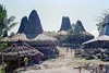
Village with grass covered roof houses on the island of Sumba. In front of this houses many megalithic tombs (graves) are standing.
You may be viewing yesterday's version of this page. To see the most up to date information please register for a free account.
Do not use the above information on other web sites or publications without permission of the contributor.
Nearby Images from Flickr

The above images may not be of the site on this page, but were taken nearby. They are loaded from Flickr so please click on them for image credits.
Click here to see more info for this site
Nearby sites
Click here to view sites on an interactive map of the areaKey: Red: member's photo, Blue: 3rd party photo, Yellow: other image, Green: no photo - please go there and take one, Grey: site destroyed
Download sites to:
KML (Google Earth)
GPX (GPS waypoints)
CSV (Garmin/Navman)
CSV (Excel)
To unlock full downloads you need to sign up as a Contributory Member. Otherwise downloads are limited to 50 sites.
Turn off the page maps and other distractions
Nearby sites listing. In the following links * = Image available
2.8km ESE 113° Waikabubak East Burial Chamber or Dolmen
18.9km ENE 75° Anakalang Burial Chamber or Dolmen
121.7km E 94° Rindi Umalulu Burial Chamber or Dolmen
167.1km NE 43° Liang Bua Cave Cave or Rock Shelter
192.5km ENE 64° Bena Village Megaliths* Ancient Village or Settlement
456.5km WNW 288° Pura Besakih Ancient Temple
467.3km WNW 285° Goa Garba* Cave or Rock Shelter
468.0km WNW 285° Yeh Pulu* Carving
468.4km WNW 285° Archaelogical Museum Gedong Arca* Museum
469.4km WNW 286° Gunung Kawi* Ancient Temple
473.2km W 280° Pura Batu Pageh* Ancient Temple
498.7km N 0° Maros (Sulawesi) Rock Art
518.3km N 3° Leang Leang Rock Art
568.9km WNW 286° Museum Manusia Purba Gilimanuk* Museum
737.0km N 4° Londa Tana Toraja Rock Cut Tomb
740.0km N 4° Ke´te Kesu´ Standing Stones* Stone Circle
742.0km N 2° Pali Standing Stones* Standing Stones
748.4km N 4° Batu-Batu Standing Stones Standing Stones
748.5km N 4° Bori Kalimbuang* Stone Circle
866.6km N 6° Bada Valley Megaliths* Sculptured Stone
872.1km E 82° Jerimalai Cave or Rock Shelter
912.5km N 7° Situs Pekasele* Sculptured Stone
937.6km SE 124° Kalumburu Cave or Rock Shelter
1002.0km WNW 281° Prambanan Ancient Temple
1008.9km SE 128° Drysdale River National Park Rock Art
View more nearby sites and additional images


 We would like to know more about this location. Please feel free to add a brief description and any relevant information in your own language.
 Wir möchten mehr über diese Stätte erfahren. Bitte zögern Sie nicht, eine kurze Beschreibung und relevante Informationen in Deutsch hinzuzufügen.
 Nous aimerions en savoir encore un peu sur les lieux. S'il vous plaît n'hesitez pas à ajouter une courte description et tous les renseignements pertinents dans votre propre langue.
 Quisieramos informarnos un poco más de las lugares. No dude en añadir una breve descripción y otros datos relevantes en su propio idioma.