


<< Text Pages >> Pura Besakih - Ancient Temple in Indonesia
Submitted by KaiHofmann on Monday, 27 November 2017 Page Views: 1231
Multi-periodSite Name: Pura BesakihCountry: Indonesia
NOTE: This site is 122.996 km away from the location you searched for.
Type: Ancient Temple
Nearest Village: Besakih
Latitude: 8.37366S Longitude: 115.451252E
Condition:
| 5 | Perfect |
| 4 | Almost Perfect |
| 3 | Reasonable but with some damage |
| 2 | Ruined but still recognisable as an ancient site |
| 1 | Pretty much destroyed, possibly visible as crop marks |
| 0 | No data. |
| -1 | Completely destroyed |
| 5 | Superb |
| 4 | Good |
| 3 | Ordinary |
| 2 | Not Good |
| 1 | Awful |
| 0 | No data. |
| 5 | Can be driven to, probably with disabled access |
| 4 | Short walk on a footpath |
| 3 | Requiring a bit more of a walk |
| 2 | A long walk |
| 1 | In the middle of nowhere, a nightmare to find |
| 0 | No data. |
| 5 | co-ordinates taken by GPS or official recorded co-ordinates |
| 4 | co-ordinates scaled from a detailed map |
| 3 | co-ordinates scaled from a bad map |
| 2 | co-ordinates of the nearest village |
| 1 | co-ordinates of the nearest town |
| 0 | no data |
Internal Links:
External Links:
Ancient Temple in Indonesia
The hindu temple complex of Pura Besakih consists of 200 buildings. It is the most important and largest temple complexes on Bali and was founded in the 8th century CE.
You may be viewing yesterday's version of this page. To see the most up to date information please register for a free account.
Do not use the above information on other web sites or publications without permission of the contributor.
Nearby Images from Flickr
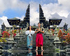
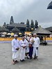
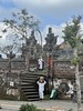
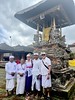
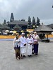
The above images may not be of the site on this page, but were taken nearby. They are loaded from Flickr so please click on them for image credits.
Click here to see more info for this site
Nearby sites
Click here to view sites on an interactive map of the areaKey: Red: member's photo, Blue: 3rd party photo, Yellow: other image, Green: no photo - please go there and take one, Grey: site destroyed
Download sites to:
KML (Google Earth)
GPX (GPS waypoints)
CSV (Garmin/Navman)
CSV (Excel)
To unlock full downloads you need to sign up as a Contributory Member. Otherwise downloads are limited to 50 sites.
Turn off the page maps and other distractions
Nearby sites listing. In the following links * = Image available
16.3km WSW 250° Gunung Kawi* Ancient Temple
22.8km SW 225° Goa Garba* Cave or Rock Shelter
23.8km SW 227° Archaelogical Museum Gedong Arca* Museum
24.7km SW 225° Yeh Pulu* Carving
61.1km SSW 210° Pura Batu Pageh* Ancient Temple
113.1km WNW 281° Museum Manusia Purba Gilimanuk* Museum
456.5km ESE 108° Waikabubak Burial Chamber or Dolmen
459.2km ESE 108° Waikabubak East Burial Chamber or Dolmen
472.6km ESE 107° Anakalang Burial Chamber or Dolmen
549.4km E 92° Liang Bua Cave Cave or Rock Shelter
550.4km W 277° Prambanan Ancient Temple
557.6km W 279° The Lost World Stonehenge. Cangkringan, Sleman. Modern Stone Circle etc
567.4km NE 51° Maros (Sulawesi) Rock Art
575.4km ESE 105° Rindi Umalulu Burial Chamber or Dolmen
584.1km W 278° Borobudur temple* Ancient Temple
584.1km W 278° Dieng Plateau Temple* Ancient Temple
600.3km NE 51° Leang Leang Rock Art
611.0km E 96° Bena Village Megaliths* Ancient Village or Settlement
623.9km WNW 282° Candi Bima Ancient Temple
624.5km WNW 282° Candi Arjuna Ancient Temple
624.5km WNW 282° Candi Gatotkaca Ancient Temple
761.6km NE 38° Pali Standing Stones* Standing Stones
771.8km NE 40° Londa Tana Toraja Rock Cut Tomb
775.1km NE 40° Ke´te Kesu´ Standing Stones* Stone Circle
782.4km NE 39° Batu-Batu Standing Stones Standing Stones
View more nearby sites and additional images


 We would like to know more about this location. Please feel free to add a brief description and any relevant information in your own language.
 Wir möchten mehr über diese Stätte erfahren. Bitte zögern Sie nicht, eine kurze Beschreibung und relevante Informationen in Deutsch hinzuzufügen.
 Nous aimerions en savoir encore un peu sur les lieux. S'il vous plaît n'hesitez pas à ajouter une courte description et tous les renseignements pertinents dans votre propre langue.
 Quisieramos informarnos un poco más de las lugares. No dude en añadir una breve descripción y otros datos relevantes en su propio idioma.