 with our Megalithic Portal iPhone app")


<< Other Photo Pages >> Kreisgrabenanlage Schönebeck - Henge in Germany in Saxony-Anhalt
Submitted by Harald_Platta on Sunday, 11 June 2017 Page Views: 2658
Neolithic and Bronze AgeSite Name: Kreisgrabenanlage SchönebeckCountry: Germany
NOTE: This site is 7.441 km away from the location you searched for.
Land: Saxony-Anhalt Type: Henge
Nearest Town: Schönebeck
Latitude: 52.006157N Longitude: 11.786887E
Condition:
| 5 | Perfect |
| 4 | Almost Perfect |
| 3 | Reasonable but with some damage |
| 2 | Ruined but still recognisable as an ancient site |
| 1 | Pretty much destroyed, possibly visible as crop marks |
| 0 | No data. |
| -1 | Completely destroyed |
| 5 | Superb |
| 4 | Good |
| 3 | Ordinary |
| 2 | Not Good |
| 1 | Awful |
| 0 | No data. |
| 5 | Can be driven to, probably with disabled access |
| 4 | Short walk on a footpath |
| 3 | Requiring a bit more of a walk |
| 2 | A long walk |
| 1 | In the middle of nowhere, a nightmare to find |
| 0 | No data. |
| 5 | co-ordinates taken by GPS or official recorded co-ordinates |
| 4 | co-ordinates scaled from a detailed map |
| 3 | co-ordinates scaled from a bad map |
| 2 | co-ordinates of the nearest village |
| 1 | co-ordinates of the nearest town |
| 0 | no data |
Internal Links:
External Links:
I have visited· I would like to visit
radrad would like to visit
Klingon saw from a distance on 4th Aug 2018 - their rating: Cond: 1 Amb: 3 Access: 4 Actually, there's nothing left to see.
")
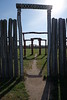
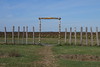
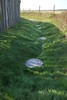
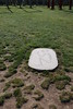
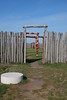
The site was discovered in the early 1990´s via aerial photography. Excavations were carried out in 2004, 2005 and 2011. The henge consists of two concentric rings and has a diameter of 80 m. Pieces of pottery and remains of human bones were found in the henge. The radiocarbon dating of the bones revealed that they stem from the time between 2150 und 1740 BC. The henge was surrounded by a Bronze Age / Iron Age barrow cemetery.
References:
[01] Schwarz, R.: Pilotstudien – Zwölf Jahre Luftbildarchäologie in Sachsen-Anhalt.
Landesamt für Denkmalpflege und Archäologie Sachsen-Anhalt, Halle (Saale) 2003, ISBN 3910010725.
[02] Spatzier, A.: Kreisgrabenanlagen des 4.–1. Jahrtausends v. Chr. in Mitteldeutschland. Vorbericht zu den Grabungen 2005 in Sachsen-Anhalt.
In: Archäologie in Sachsen-Anhalt. N. F. Band 6, 2012, S. 71–89.
[03] Universität Halle (Hrsg.): Grabungen des Jahres 2005 (http://mars.geographie.unihalle. de/for550/index.php/a2/laufende arbeiten/7grabungen2005).
[04] archaeologie-online.de: Deutsches Stone Henge II nur ohne Steine (11.09.2015).
You may be viewing yesterday's version of this page. To see the most up to date information please register for a free account.
")
Do not use the above information on other web sites or publications without permission of the contributor.
Nearby Images from Flickr

The above images may not be of the site on this page, but were taken nearby. They are loaded from Flickr so please click on them for image credits.
Click here to see more info for this site
Nearby sites
Click here to view sites on an interactive map of the areaKey: Red: member's photo, Blue: 3rd party photo, Yellow: other image, Green: no photo - please go there and take one, Grey: site destroyed
Download sites to:
KML (Google Earth)
GPX (GPS waypoints)
CSV (Garmin/Navman)
CSV (Excel)
To unlock full downloads you need to sign up as a Contributory Member. Otherwise downloads are limited to 50 sites.
Turn off the page maps and other distractions
Nearby sites listing. In the following links * = Image available
1.3km SE 139° Pömmelte Kultstätte* Timber Circle
11.4km E 88° Gehrden Langbett* Long Barrow
13.1km S 184° Trojaburg Calbe Turf Maze
15.7km NE 40° Luetnitz Steingrab* Burial Chamber or Dolmen
17.9km NW 310° Kroatenhügel* Chambered Tomb
18.4km N 2° Koerbelitz Steingrab* Chambered Tomb
19.4km N 359° Körbelitz Steinkreuze* Ancient Cross
19.8km WNW 300° Hängelsberge* Chambered Tomb
19.9km S 174° Bierberg Gerbitz* Chambered Tomb
19.9km S 179° Heringsberg* Chambered Tomb
21.1km NW 323° Kleiner Silberberg* Burial Chamber or Dolmen
21.2km ESE 106° Teufelstein Zerbst Natural Stone / Erratic / Other Natural Feature
21.6km SSE 157° Teufelskeller Drosa* Burial Chamber or Dolmen
21.6km NW 325° Grosser Silberberg* Burial Chamber or Dolmen
22.3km S 180° Pfingstberg Latdorf* Standing Stone (Menhir)
22.6km S 172° Steinerne Hütte* Chambered Tomb
22.6km S 176° Pohlsberg Latdorf* Artificial Mound
22.9km NNW 329° Pfahlberg* Burial Chamber or Dolmen
22.9km S 172° Spitzes Hoch* Round Barrow(s)
23.1km SSE 155° Hoher Berg Wulfen* Passage Grave
24.1km S 171° Fuchsberg (Weddegast)* Barrow Cemetery
24.3km SSW 199° Sechs Steine* Early Christian Sculptured Stone
26.0km SSW 207° Guddenstein* Standing Stone (Menhir)
26.5km S 179° Schneiderberg Baalberge* Round Barrow(s)
26.5km NNE 29° Grosssteingrab Grabow* Burial Chamber or Dolmen
View more nearby sites and additional images


 We would like to know more about this location. Please feel free to add a brief description and any relevant information in your own language.
 Wir möchten mehr über diese Stätte erfahren. Bitte zögern Sie nicht, eine kurze Beschreibung und relevante Informationen in Deutsch hinzuzufügen.
 Nous aimerions en savoir encore un peu sur les lieux. S'il vous plaît n'hesitez pas à ajouter une courte description et tous les renseignements pertinents dans votre propre langue.
 Quisieramos informarnos un poco más de las lugares. No dude en añadir una breve descripción y otros datos relevantes en su propio idioma.