

<< Our Photo Pages >> Vestgårdøya Bronze age Cairn - Cairn in Norway in Østfold
Submitted by 43559959 on Monday, 24 August 2015 Page Views: 1394
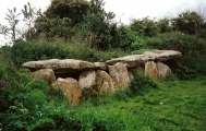
Neolithic and Bronze AgeSite Name: Vestgårdøya Bronze age Cairn Alternative Name: ZODIAC CairnCountry: Norway
NOTE: This site is 16.594 km away from the location you searched for.
Fylke: Østfold Type: Cairn
Nearest Town: Halden Nearest Village: Tistedal
Latitude: 59.169200N Longitude: 11.711010E
Condition:
| 5 | Perfect |
| 4 | Almost Perfect |
| 3 | Reasonable but with some damage |
| 2 | Ruined but still recognisable as an ancient site |
| 1 | Pretty much destroyed, possibly visible as crop marks |
| 0 | No data. |
| -1 | Completely destroyed |
| 5 | Superb |
| 4 | Good |
| 3 | Ordinary |
| 2 | Not Good |
| 1 | Awful |
| 0 | No data. |
| 5 | Can be driven to, probably with disabled access |
| 4 | Short walk on a footpath |
| 3 | Requiring a bit more of a walk |
| 2 | A long walk |
| 1 | In the middle of nowhere, a nightmare to find |
| 0 | No data. |
| 5 | co-ordinates taken by GPS or official recorded co-ordinates |
| 4 | co-ordinates scaled from a detailed map |
| 3 | co-ordinates scaled from a bad map |
| 2 | co-ordinates of the nearest village |
| 1 | co-ordinates of the nearest town |
| 0 | no data |
Internal Links:
External Links:
I have visited· I would like to visit
43559959 visited on 10th Jul 2015 - their rating: Cond: 2 Amb: 4 Access: 1
")
It is not a nightmare to find, but you need a boat of some kind to get there.
The cairn has been opened up and seems to contain three graves that lie exposed.
There is a standing stone close by, but I suppose this is not ancient.
You may be viewing yesterday's version of this page. To see the most up to date information please register for a free account.
")
")
")
Do not use the above information on other web sites or publications without permission of the contributor.
Nearby Images from Flickr
The above images may not be of the site on this page, but were taken nearby. They are loaded from Flickr so please click on them for image credits.
Click here to see more info for this site
Nearby sites
Click here to view sites on an interactive map of the areaKey: Red: member's photo, Blue: 3rd party photo, Yellow: other image, Green: no photo - please go there and take one, Grey: site destroyed
Download sites to:
KML (Google Earth)
GPX (GPS waypoints)
CSV (Garmin/Navman)
CSV (Excel)
To unlock full downloads you need to sign up as a Contributory Member. Otherwise downloads are limited to 50 sites.
Turn off the page maps and other distractions
Nearby sites listing. In the following links * = Image available
13.0km N 351° Søndre Fange Hellekiste* Passage Grave
17.2km WSW 243° Åskasa* Barrow Cemetery
17.3km WSW 252° Harekasfjellet* Hillfort
20.2km W 275° Tre Furuer* Barrow Cemetery
20.6km W 276° Rokke barrow cemetery* Barrow Cemetery
23.0km W 261° Bautastein (Halden)* Standing Stone (Menhir)
25.5km W 266° Vestre Huseby* Barrow Cemetery
25.5km W 268° Tingstedet-Ekås* Stone Circle
25.5km W 268° Kongeveien-Tingstedet* Stone Circle
26.3km W 266° Alkerød* Rock Art
26.3km WNW 284° Gunhildås* Hillfort
26.3km W 265° Jellhaugen Mound* Round Barrow(s)
26.4km WNW 295° Trinborg* Hillfort
26.7km W 266° Hjelmungen* Rock Art
26.9km WNW 286° Slottsfjellet* Hillfort
27.0km W 272° Bissebergkasa* Stone Circle
28.7km WNW 284° Rønneld stone circle* Stone Circle
28.7km WNW 284° Rønnild Barrow Cemetery* Barrow Cemetery
29.1km W 279° Løkke* Cairn
29.3km WNW 285° Steinane* Cairn
29.7km W 279° Åsgarden cairn* Cairn
29.7km W 279° Guslund Nedre* Ancient Village or Settlement
29.8km WNW 286° Vik Stone Rings* Stone Circle
29.8km WNW 286° Rokkeveien-Vik Stone Circles* Stone Circle
29.9km W 275° Høysand* Stone Circle
View more nearby sites and additional images


 We would like to know more about this location. Please feel free to add a brief description and any relevant information in your own language.
 Wir möchten mehr über diese Stätte erfahren. Bitte zögern Sie nicht, eine kurze Beschreibung und relevante Informationen in Deutsch hinzuzufügen.
 Nous aimerions en savoir encore un peu sur les lieux. S'il vous plaît n'hesitez pas à ajouter une courte description et tous les renseignements pertinents dans votre propre langue.
 Quisieramos informarnos un poco más de las lugares. No dude en añadir una breve descripción y otros datos relevantes en su propio idioma.