 with our Megalithic Portal iPhone app")


<< Our Photo Pages >> Zwölf Apostel - Stone Row / Alignment in Germany in Bavaria
Submitted by AlexHunger on Saturday, 08 October 2005 Page Views: 6381
Neolithic and Bronze AgeSite Name: Zwölf Apostel Alternative Name: 12 ApostelCountry: Germany
NOTE: This site is 8.516 km away from the location you searched for.
Land: Bavaria Type: Stone Row / Alignment
Nearest Town: Bad Steben Nearest Village: Langenbach
Latitude: 50.369490N Longitude: 11.590260E
Condition:
| 5 | Perfect |
| 4 | Almost Perfect |
| 3 | Reasonable but with some damage |
| 2 | Ruined but still recognisable as an ancient site |
| 1 | Pretty much destroyed, possibly visible as crop marks |
| 0 | No data. |
| -1 | Completely destroyed |
| 5 | Superb |
| 4 | Good |
| 3 | Ordinary |
| 2 | Not Good |
| 1 | Awful |
| 0 | No data. |
| 5 | Can be driven to, probably with disabled access |
| 4 | Short walk on a footpath |
| 3 | Requiring a bit more of a walk |
| 2 | A long walk |
| 1 | In the middle of nowhere, a nightmare to find |
| 0 | No data. |
| 5 | co-ordinates taken by GPS or official recorded co-ordinates |
| 4 | co-ordinates scaled from a detailed map |
| 3 | co-ordinates scaled from a bad map |
| 2 | co-ordinates of the nearest village |
| 1 | co-ordinates of the nearest town |
| 0 | no data |
Internal Links:
External Links:
I have visited· I would like to visit
ModernExplorers visited on 16th Jul 2018 - their rating: Cond: 4 Amb: 5 Access: 4
trystan_hughes visited on 6th Aug 2015 - their rating: Cond: 4 Amb: 5 Access: 4 Wonderful views all around... worth a little visit if you are close by :-)
Klingon have visited here
Average ratings for this site from all visit loggers: Condition: 4 Ambience: 5 Access: 4
")
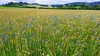
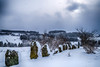
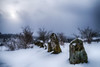
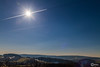
Alignment of 12 stones on side of hill. The stones are NNE-SSW aligned. Approximately set 3000 BC.
zwölf Apostel = twelve apostles
Co-ordinates by GPS.
You may be viewing yesterday's version of this page. To see the most up to date information please register for a free account.
")
")
")
Do not use the above information on other web sites or publications without permission of the contributor.
Nearby Images from Flickr

The above images may not be of the site on this page, but were taken nearby. They are loaded from Flickr so please click on them for image credits.
Click here to see more info for this site
Nearby sites
Click here to view sites on an interactive map of the areaKey: Red: member's photo, Blue: 3rd party photo, Yellow: other image, Green: no photo - please go there and take one, Grey: site destroyed
Download sites to:
KML (Google Earth)
GPX (GPS waypoints)
CSV (Garmin/Navman)
CSV (Excel)
To unlock full downloads you need to sign up as a Contributory Member. Otherwise downloads are limited to 50 sites.
Turn off the page maps and other distractions
Nearby sites listing. In the following links * = Image available
27.9km SW 216° Schamelstein Sculptured Stone
28.8km W 267° Marterstein Sonneberg* Standing Stone (Menhir)
31.5km ESE 118° Das Quellenreuther Steinkreuz* Ancient Cross
31.6km NNW 333° Teufelsbruecke Obernitz Cave or Rock Shelter
31.8km ESE 119° Quellenreuth Stein* Standing Stone (Menhir)
31.9km N 349° Clythenhöhle Cave or Rock Shelter
32.3km SE 133° Hallerstein* Standing Stone (Menhir)
32.4km SE 139° Hoher Stein Fichtelgebirge Natural Stone / Erratic / Other Natural Feature
32.6km N 357° Ilsenhöhle* Cave or Rock Shelter
33.1km N 356° Herthahöhle Cave or Rock Shelter
33.2km N 356° Herdloch Ranis Cave or Rock Shelter
33.7km N 359° Langer Berg Ranis-Ludwigshof Round Barrow(s)
34.1km N 360° Franzosenhöhle Wernburg Cave or Rock Shelter
34.1km N 355° Binsenberg Ancient Village or Settlement
34.2km N 358° Breiter Berg Ranis-Brandenstein* Round Barrow(s)
34.2km N 360° Höhle Wernburg Cave or Rock Shelter
34.9km N 0° Fuchshügel Round Barrow(s)
35.3km N 1° Altenburg Pößneck Causewayed Enclosure
35.4km N 1° Bildermollenhöhle Cave or Rock Shelter
35.4km N 2° Griebse Ancient Mine, Quarry or other Industry
35.6km N 5° Richterhöhle Cave or Rock Shelter
35.6km N 6° Wüste Scheuer Cave or Rock Shelter
35.8km N 6° Kniegrotte Cave or Rock Shelter
35.9km N 6° Urdhöhle Cave or Rock Shelter
36.9km N 9° Solkwitz Round Barrow(s)
View more nearby sites and additional images


 We would like to know more about this location. Please feel free to add a brief description and any relevant information in your own language.
 Wir möchten mehr über diese Stätte erfahren. Bitte zögern Sie nicht, eine kurze Beschreibung und relevante Informationen in Deutsch hinzuzufügen.
 Nous aimerions en savoir encore un peu sur les lieux. S'il vous plaît n'hesitez pas à ajouter une courte description et tous les renseignements pertinents dans votre propre langue.
 Quisieramos informarnos un poco más de las lugares. No dude en añadir una breve descripción y otros datos relevantes en su propio idioma.